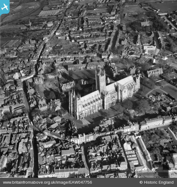
EAW047756 ENGLAND (1952). Christchurch Cathedral, Canterbury, 1952
© Copyright OpenStreetMap contributors and licensed by the OpenStreetMap Foundation. 2026. Cartography is licensed as CC BY-SA.
Nearby Images (26)
Details
| Title | [EAW047756] Christchurch Cathedral, Canterbury, 1952 |
| Reference | EAW047756 |
| Date | 11-November-1952 |
| Link | |
| Place name | CANTERBURY |
| Parish | |
| District | |
| Country | ENGLAND |
| Easting / Northing | 615089, 157958 |
| Longitude / Latitude | 1.0844628191269, 51.279584824237 |
| National Grid Reference | TR151580 |
Pins

Gone2Kent |
Saturday 12th of July 2014 03:00:08 PM | |

Gone2Kent |
Saturday 12th of July 2014 02:55:50 PM | |

Gone2Kent |
Saturday 12th of July 2014 02:55:45 PM | |

Gone2Kent |
Saturday 12th of July 2014 02:53:59 PM | |

Gone2Kent |
Saturday 12th of July 2014 02:47:15 PM | |

Gone2Kent |
Saturday 12th of July 2014 02:46:13 PM | |

Gone2Kent |
Saturday 12th of July 2014 02:43:41 PM | |

Alan McFaden |
Saturday 12th of July 2014 09:35:33 AM |


![[EAW047756] Christchurch Cathedral, Canterbury, 1952](http://britainfromabove.org.uk/sites/all/libraries/aerofilms-images/public/100x100/EAW/047/EAW047756.jpg)
![[EAW047755] Christchurch Cathedral, Canterbury, 1952](http://britainfromabove.org.uk/sites/all/libraries/aerofilms-images/public/100x100/EAW/047/EAW047755.jpg)
![[EPW013271] Christ Church Cathedral and the town centre, Canterbury, 1925](http://britainfromabove.org.uk/sites/all/libraries/aerofilms-images/public/100x100/EPW/013/EPW013271.jpg)
![[EPW009144] Christchurch Cathedral and the city, Canterbury, 1923. This image has been produced from a copy-negative.](http://britainfromabove.org.uk/sites/all/libraries/aerofilms-images/public/100x100/EPW/009/EPW009144.jpg)
![[EAW004809] Christchurch Cathedral and the cathedral close, Canterbury, 1947](http://britainfromabove.org.uk/sites/all/libraries/aerofilms-images/public/100x100/EAW/004/EAW004809.jpg)
![[EAW011399] Christ Church Cathedral, Canterbury, 1947](http://britainfromabove.org.uk/sites/all/libraries/aerofilms-images/public/100x100/EAW/011/EAW011399.jpg)
![[EPW009139] Christ Church Cathedral and environs, Canterbury, 1923](http://britainfromabove.org.uk/sites/all/libraries/aerofilms-images/public/100x100/EPW/009/EPW009139.jpg)
![[EAW047757] Christchurch Cathedral, Canterbury, 1952](http://britainfromabove.org.uk/sites/all/libraries/aerofilms-images/public/100x100/EAW/047/EAW047757.jpg)
![[EPW009140] Christ Church Cathedral and environs, Canterbury, 1923](http://britainfromabove.org.uk/sites/all/libraries/aerofilms-images/public/100x100/EPW/009/EPW009140.jpg)
![[EAW004807] Christchurch Cathedral and the cathedral close, Canterbury, 1947](http://britainfromabove.org.uk/sites/all/libraries/aerofilms-images/public/100x100/EAW/004/EAW004807.jpg)
![[EAW004808] Christchurch Cathedral and the cathedral close, Canterbury, 1947](http://britainfromabove.org.uk/sites/all/libraries/aerofilms-images/public/100x100/EAW/004/EAW004808.jpg)
![[EPW038149] Canterbury Cathedral, Canterbury, 1932](http://britainfromabove.org.uk/sites/all/libraries/aerofilms-images/public/100x100/EPW/038/EPW038149.jpg)
![[EAW004806] Christchurch Cathedral and the cathedral close, Canterbury, 1947](http://britainfromabove.org.uk/sites/all/libraries/aerofilms-images/public/100x100/EAW/004/EAW004806.jpg)
![[EPW009147] Christchurch Cathedral and environs, Canterbury, 1923. This image has been produced from a copy-negative.](http://britainfromabove.org.uk/sites/all/libraries/aerofilms-images/public/100x100/EPW/009/EPW009147.jpg)
![[EPW000393] Christchurch Cathedral, Canterbury, from the south-east, 1920](http://britainfromabove.org.uk/sites/all/libraries/aerofilms-images/public/100x100/EPW/000/EPW000393.jpg)
![[EPW013272] Christ Church Cathedral and the city, Canterbury, 1925. This image has been produced from a copy-negative.](http://britainfromabove.org.uk/sites/all/libraries/aerofilms-images/public/100x100/EPW/013/EPW013272.jpg)
![[EPW009146] Christchurch Cathedral and environs, Canterbury, 1923. This image has been produced from a copy-negative.](http://britainfromabove.org.uk/sites/all/libraries/aerofilms-images/public/100x100/EPW/009/EPW009146.jpg)
![[EPW009141] Christchurch Cathedral and environs, Canterbury, 1923. This image has been produced from a copy-negative.](http://britainfromabove.org.uk/sites/all/libraries/aerofilms-images/public/100x100/EPW/009/EPW009141.jpg)
![[EPW009143] Christchurch Cathedral and the city, Canterbury, 1923. This image has been produced from a print.](http://britainfromabove.org.uk/sites/all/libraries/aerofilms-images/public/100x100/EPW/009/EPW009143.jpg)
![[EAW028821] Christ Church Cathedral and the city, Canterbury, 1950](http://britainfromabove.org.uk/sites/all/libraries/aerofilms-images/public/100x100/EAW/028/EAW028821.jpg)
![[EAW028822] Christ Church Cathedral and the city, Canterbury, 1950](http://britainfromabove.org.uk/sites/all/libraries/aerofilms-images/public/100x100/EAW/028/EAW028822.jpg)
![[EAW017600] Christ Church Cathedral and the surrounding city, Canterbury, from the south-west, 1948. This image has been produced from a print.](http://britainfromabove.org.uk/sites/all/libraries/aerofilms-images/public/100x100/EAW/017/EAW017600.jpg)
![[EAW014335] Christ Church Cathedral and the city, Canterbury, from the south-west, 1948](http://britainfromabove.org.uk/sites/all/libraries/aerofilms-images/public/100x100/EAW/014/EAW014335.jpg)
![[EAW017599] Christ Church Cathedral and the surrounding city, Canterbury, from the south, 1948. This image has been produced from a print.](http://britainfromabove.org.uk/sites/all/libraries/aerofilms-images/public/100x100/EAW/017/EAW017599.jpg)
![[EAW017598] Christ Church Cathedral and the surrounding city, Canterbury, from the south, 1948. This image has been produced from a print.](http://britainfromabove.org.uk/sites/all/libraries/aerofilms-images/public/100x100/EAW/017/EAW017598.jpg)
![[EAW014334] Christ Church Cathedral and the city, Canterbury, from the east, 1948. This image has been produced from a damaged negative.](http://britainfromabove.org.uk/sites/all/libraries/aerofilms-images/public/100x100/EAW/014/EAW014334.jpg)
