
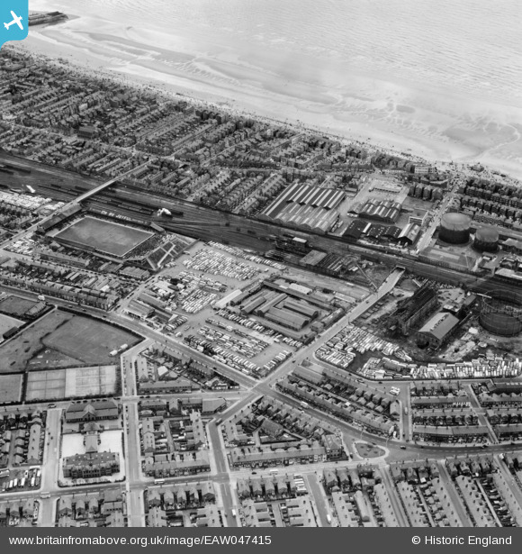
EAW047415 ENGLAND (1952). Rigby Road and adjacent coach and car park, Bloomfield Road Football Ground (Blackpool Football Club) and environs, Blackpool, 1952
© Copyright OpenStreetMap contributors and licensed by the OpenStreetMap Foundation. 2026. Cartography is licensed as CC BY-SA.
Nearby Images (4)
EAW047415
 and environs, Blackpool, 1952")
EAW047416

EAW039907

EAW026230

Details
| Title | [EAW047415] Rigby Road and adjacent coach and car park, Bloomfield Road Football Ground (Blackpool Football Club) and environs, Blackpool, 1952 |
| Reference | EAW047415 |
| Date | 10-October-1952 |
| Link | |
| Place name | BLACKPOOL |
| Parish | |
| District | |
| Country | ENGLAND |
| Easting / Northing | 331026, 434988 |
| Longitude / Latitude | -3.0475069821532, 53.806393020117 |
| National Grid Reference | SD310350 |
Pins

stephen sweetie |
Wednesday 2nd of October 2019 04:52:33 PM | |
|
Owen |
Thursday 20th of August 2015 10:45:19 PM | |

Maurice |
Saturday 25th of July 2015 08:42:28 AM | |
|
Maurice |
Saturday 25th of July 2015 08:32:31 AM | |
|
John Wass |
Thursday 30th of April 2015 04:17:23 PM | |
|
Groundling |
Saturday 2nd of August 2014 08:41:22 AM |
User Comment Contributions
Blackpool FC, 1952 |
Mattle |
Friday 4th of July 2014 10:28:47 PM |