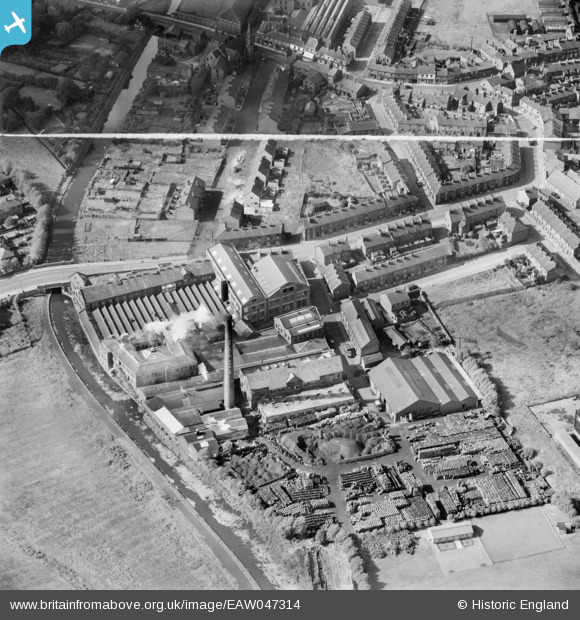
EAW047314 ENGLAND (1952). Robertson's Golden Shred Works and environs, Audenshaw, 1952. This image was marked by Aerofilms Ltd for photo editing.
© Copyright OpenStreetMap contributors and licensed by the OpenStreetMap Foundation. 2026. Cartography is licensed as CC BY-SA.
Nearby Images (16)
Details
| Title | [EAW047314] Robertson's Golden Shred Works and environs, Audenshaw, 1952. This image was marked by Aerofilms Ltd for photo editing. |
| Reference | EAW047314 |
| Date | 17-September-1952 |
| Link | |
| Place name | AUDENSHAW |
| Parish | |
| District | |
| Country | ENGLAND |
| Easting / Northing | 390541, 397727 |
| Longitude / Latitude | -2.1425328466518, 53.475933886417 |
| National Grid Reference | SJ905977 |
Pins

redmist |
Monday 31st of December 2018 10:25:33 AM | |

redmist |
Monday 31st of December 2018 10:17:20 AM | |

John T. Pitman |
Wednesday 15th of October 2014 12:57:48 AM | |

John T. Pitman |
Wednesday 15th of October 2014 12:55:56 AM |


![[EAW047314] Robertson's Golden Shred Works and environs, Audenshaw, 1952. This image was marked by Aerofilms Ltd for photo editing.](http://britainfromabove.org.uk/sites/all/libraries/aerofilms-images/public/100x100/EAW/047/EAW047314.jpg)
![[EAW047313] Robertson's Golden Shred Works and environs, Audenshaw, 1952. This image was marked by Aerofilms Ltd for photo editing.](http://britainfromabove.org.uk/sites/all/libraries/aerofilms-images/public/100x100/EAW/047/EAW047313.jpg)
![[EPW007678] Robertson's Golden Shred Works, Droylsden, 1922](http://britainfromabove.org.uk/sites/all/libraries/aerofilms-images/public/100x100/EPW/007/EPW007678.jpg)
![[EPW007679] Robertson's Golden Shred Works, Droylsden, 1922](http://britainfromabove.org.uk/sites/all/libraries/aerofilms-images/public/100x100/EPW/007/EPW007679.jpg)
![[EAW047319] Robertson's Golden Shred Works and environs, Audenshaw, 1952. This image was marked by Aerofilms Ltd for photo editing.](http://britainfromabove.org.uk/sites/all/libraries/aerofilms-images/public/100x100/EAW/047/EAW047319.jpg)
![[EAW047311] Robertson's Golden Shred Works and Ashton Hill Lane, Audenshaw, 1952. This image was marked by Aerofilms Ltd for photo editing.](http://britainfromabove.org.uk/sites/all/libraries/aerofilms-images/public/100x100/EAW/047/EAW047311.jpg)
![[EPW007677] Robertson's Golden Shred Works, Droylsden, 1922](http://britainfromabove.org.uk/sites/all/libraries/aerofilms-images/public/100x100/EPW/007/EPW007677.jpg)
![[EAW047318] Robertson's Golden Shred Works, Audenshaw, 1952. This image was marked by Aerofilms Ltd for photo editing.](http://britainfromabove.org.uk/sites/all/libraries/aerofilms-images/public/100x100/EAW/047/EAW047318.jpg)
![[EAW047317] Robertson's Golden Shred Works, Audenshaw, 1952. This image was marked by Aerofilms Ltd for photo editing.](http://britainfromabove.org.uk/sites/all/libraries/aerofilms-images/public/100x100/EAW/047/EAW047317.jpg)
![[EPW007675] Robertson's Golden Shred Works, Droylsden, 1922](http://britainfromabove.org.uk/sites/all/libraries/aerofilms-images/public/100x100/EPW/007/EPW007675.jpg)
![[EPW007676] Robertson's Golden Shred Works, Droylsden, 1922](http://britainfromabove.org.uk/sites/all/libraries/aerofilms-images/public/100x100/EPW/007/EPW007676.jpg)
![[EAW047312] Robertson's Golden Shred Works, Audenshaw, 1952. This image was marked by Aerofilms Ltd for photo editing.](http://britainfromabove.org.uk/sites/all/libraries/aerofilms-images/public/100x100/EAW/047/EAW047312.jpg)
![[EAW047315] Robertson's Golden Shred Works, Audenshaw, 1952. This image was marked by Aerofilms Ltd for photo editing.](http://britainfromabove.org.uk/sites/all/libraries/aerofilms-images/public/100x100/EAW/047/EAW047315.jpg)
![[EAW047320] Robertson's Golden Shred Works, Audenshaw, 1952. This image was marked by Aerofilms Ltd for photo editing.](http://britainfromabove.org.uk/sites/all/libraries/aerofilms-images/public/100x100/EAW/047/EAW047320.jpg)
![[EAW047321] Robertson's Golden Shred Works, Audenshaw, 1952. This image was marked by Aerofilms Ltd for photo editing.](http://britainfromabove.org.uk/sites/all/libraries/aerofilms-images/public/100x100/EAW/047/EAW047321.jpg)
![[EAW047316] Robertson's Golden Shred Works and the Manchester and Ashton under Lyne Canal, Audenshaw, 1952](http://britainfromabove.org.uk/sites/all/libraries/aerofilms-images/public/100x100/EAW/047/EAW047316.jpg)