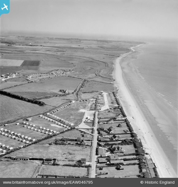
EAW046795 ENGLAND (1952). East Bracklesham Drive, the Redskin Caravan Co Ltd Caravan Park at Bracklesham Bay and environs, Bracklesham, from the north-west, 1952
© Copyright OpenStreetMap contributors and licensed by the OpenStreetMap Foundation. 2026. Cartography is licensed as CC BY-SA.
Nearby Images (17)
Details
| Title | [EAW046795] East Bracklesham Drive, the Redskin Caravan Co Ltd Caravan Park at Bracklesham Bay and environs, Bracklesham, from the north-west, 1952 |
| Reference | EAW046795 |
| Date | 16-September-1952 |
| Link | |
| Place name | BRACKLESHAM |
| Parish | EAST WITTERING |
| District | |
| Country | ENGLAND |
| Easting / Northing | 481412, 95851 |
| Longitude / Latitude | -0.84570005749422, 50.755969535557 |
| National Grid Reference | SZ814959 |
Pins
Be the first to add a comment to this image!


![[EAW046795] East Bracklesham Drive, the Redskin Caravan Co Ltd Caravan Park at Bracklesham Bay and environs, Bracklesham, from the north-west, 1952](http://britainfromabove.org.uk/sites/all/libraries/aerofilms-images/public/100x100/EAW/046/EAW046795.jpg)
![[EAW046954] Redskin Caravan Co Ltd Caravan Park at Bracklesham Bay, Bracklesham, from the north-west, 1952. This image was marked by Aerofilms Ltd for photo editing.](http://britainfromabove.org.uk/sites/all/libraries/aerofilms-images/public/100x100/EAW/046/EAW046954.jpg)
![[EAW046957] Redskin Caravan Co Ltd Caravan Park at Bracklesham Bay, Bracklesham, from the north-west, 1952](http://britainfromabove.org.uk/sites/all/libraries/aerofilms-images/public/100x100/EAW/046/EAW046957.jpg)
![[EAW046792] Redskin Caravan Co Ltd Caravan Park at Bracklesham Bay, Bracklesham, 1952. This image was marked by Aerofilms Ltd for photo editing.](http://britainfromabove.org.uk/sites/all/libraries/aerofilms-images/public/100x100/EAW/046/EAW046792.jpg)
![[EAW046793] Redskin Caravan Co Ltd Caravan Park at Bracklesham Bay, Bracklesham, 1952. This image was marked by Aerofilms Ltd for photo editing.](http://britainfromabove.org.uk/sites/all/libraries/aerofilms-images/public/100x100/EAW/046/EAW046793.jpg)
![[EAW046796] East Bracklesham Drive, the Redskin Caravan Co Ltd Caravan Park at Bracklesham Bay and environs, Bracklesham, 1952](http://britainfromabove.org.uk/sites/all/libraries/aerofilms-images/public/100x100/EAW/046/EAW046796.jpg)
![[EAW046950] Redskin Caravan Co Ltd Caravan Park at Bracklesham Bay, Bracklesham, 1952](http://britainfromabove.org.uk/sites/all/libraries/aerofilms-images/public/100x100/EAW/046/EAW046950.jpg)
![[EAW046953] Redskin Caravan Co Ltd Caravan Park at Bracklesham Bay, Bracklesham, from the north-west, 1952. This image was marked by Aerofilms Ltd for photo editing.](http://britainfromabove.org.uk/sites/all/libraries/aerofilms-images/public/100x100/EAW/046/EAW046953.jpg)
![[EAW046956] Redskin Caravan Co Ltd Caravan Park at Bracklesham Bay, Bracklesham, 1952](http://britainfromabove.org.uk/sites/all/libraries/aerofilms-images/public/100x100/EAW/046/EAW046956.jpg)
![[EAW046789] East Bracklesham Drive and the Redskin Caravan Co Ltd Caravan Park at Bracklesham Bay and environs, Bracklesham, from the north-west, 1952. This image was marked by Aerofilms Ltd for photo editing.](http://britainfromabove.org.uk/sites/all/libraries/aerofilms-images/public/100x100/EAW/046/EAW046789.jpg)
![[EAW046951] Redskin Caravan Co Ltd Caravan Park at Bracklesham Bay, Bracklesham, 1952](http://britainfromabove.org.uk/sites/all/libraries/aerofilms-images/public/100x100/EAW/046/EAW046951.jpg)
![[EAW046790] Redskin Caravan Co Ltd Caravan Park at Bracklesham Bay, Bracklesham, 1952. This image was marked by Aerofilms Ltd for photo editing.](http://britainfromabove.org.uk/sites/all/libraries/aerofilms-images/public/100x100/EAW/046/EAW046790.jpg)
![[EAW046787] Redskin Caravan Co Ltd Caravan Park at Bracklesham Bay, Bracklesham, 1952. This image was marked by Aerofilms Ltd for photo editing.](http://britainfromabove.org.uk/sites/all/libraries/aerofilms-images/public/100x100/EAW/046/EAW046787.jpg)
![[EAW046788] Redskin Caravan Co Ltd Caravan Park at Bracklesham Bay and environs, Bracklesham, from the south-east, 1952](http://britainfromabove.org.uk/sites/all/libraries/aerofilms-images/public/100x100/EAW/046/EAW046788.jpg)
![[EAW046791] Redskin Caravan Co Ltd Caravan Park at Bracklesham Bay, Bracklesham, 1952. This image was marked by Aerofilms Ltd for photo editing.](http://britainfromabove.org.uk/sites/all/libraries/aerofilms-images/public/100x100/EAW/046/EAW046791.jpg)
![[EAW046949] Redskin Caravan Co Ltd Caravan Park at Bracklesham Bay, Bracklesham, from the south-east, 1952. This image was marked by Aerofilms Ltd for photo editing.](http://britainfromabove.org.uk/sites/all/libraries/aerofilms-images/public/100x100/EAW/046/EAW046949.jpg)
![[EAW046948] Redskin Caravan Co Ltd Caravan Park at Bracklesham Bay, Bracklesham, from the south-east, 1952. This image was marked by Aerofilms Ltd for photo editing.](http://britainfromabove.org.uk/sites/all/libraries/aerofilms-images/public/100x100/EAW/046/EAW046948.jpg)