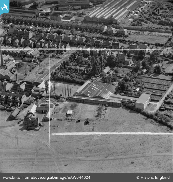
EAW044624 ENGLAND (1952). The Anglo Pencil Co Ltd Pencil Factory and environs, Long Eaton, 1952. This image was marked by Aerofilms Ltd for photo editing.
© Copyright OpenStreetMap contributors and licensed by the OpenStreetMap Foundation. 2026. Cartography is licensed as CC BY-SA.
Nearby Images (8)
Details
| Title | [EAW044624] The Anglo Pencil Co Ltd Pencil Factory and environs, Long Eaton, 1952. This image was marked by Aerofilms Ltd for photo editing. |
| Reference | EAW044624 |
| Date | 15-July-1952 |
| Link | |
| Place name | LONG EATON |
| Parish | |
| District | |
| Country | ENGLAND |
| Easting / Northing | 449360, 332850 |
| Longitude / Latitude | -1.2662736901617, 52.890512603378 |
| National Grid Reference | SK494329 |
Pins

Debs. |
Wednesday 17th of December 2014 11:55:21 AM |


![[EAW044624] The Anglo Pencil Co Ltd Pencil Factory and environs, Long Eaton, 1952. This image was marked by Aerofilms Ltd for photo editing.](http://britainfromabove.org.uk/sites/all/libraries/aerofilms-images/public/100x100/EAW/044/EAW044624.jpg)
![[EAW044623] The Anglo Pencil Co Ltd Pencil Factory and Oakley's Farm, Long Eaton, 1952. This image was marked by Aerofilms Ltd for photo editing.](http://britainfromabove.org.uk/sites/all/libraries/aerofilms-images/public/100x100/EAW/044/EAW044623.jpg)
![[EAW044617] The Anglo Pencil Co Ltd Pencil Factory, Long Eaton, 1952. This image was marked by Aerofilms Ltd for photo editing.](http://britainfromabove.org.uk/sites/all/libraries/aerofilms-images/public/100x100/EAW/044/EAW044617.jpg)
![[EAW044620] The Anglo Pencil Co Ltd Pencil Factory, Long Eaton, 1952. This image was marked by Aerofilms Ltd for photo editing.](http://britainfromabove.org.uk/sites/all/libraries/aerofilms-images/public/100x100/EAW/044/EAW044620.jpg)
![[EAW044619] The Anglo Pencil Co Ltd Pencil Factory, Long Eaton, 1952. This image was marked by Aerofilms Ltd for photo editing.](http://britainfromabove.org.uk/sites/all/libraries/aerofilms-images/public/100x100/EAW/044/EAW044619.jpg)
![[EAW044622] The Anglo Pencil Co Ltd Pencil Factory, Long Eaton, 1952. This image was marked by Aerofilms Ltd for photo editing.](http://britainfromabove.org.uk/sites/all/libraries/aerofilms-images/public/100x100/EAW/044/EAW044622.jpg)
![[EAW044621] The Anglo Pencil Co Ltd Pencil Factory, Long Eaton, 1952. This image was marked by Aerofilms Ltd for photo editing.](http://britainfromabove.org.uk/sites/all/libraries/aerofilms-images/public/100x100/EAW/044/EAW044621.jpg)
![[EAW044618] The Anglo Pencil Co Ltd Pencil Factory, Long Eaton, 1952. This image was marked by Aerofilms Ltd for photo editing.](http://britainfromabove.org.uk/sites/all/libraries/aerofilms-images/public/100x100/EAW/044/EAW044618.jpg)