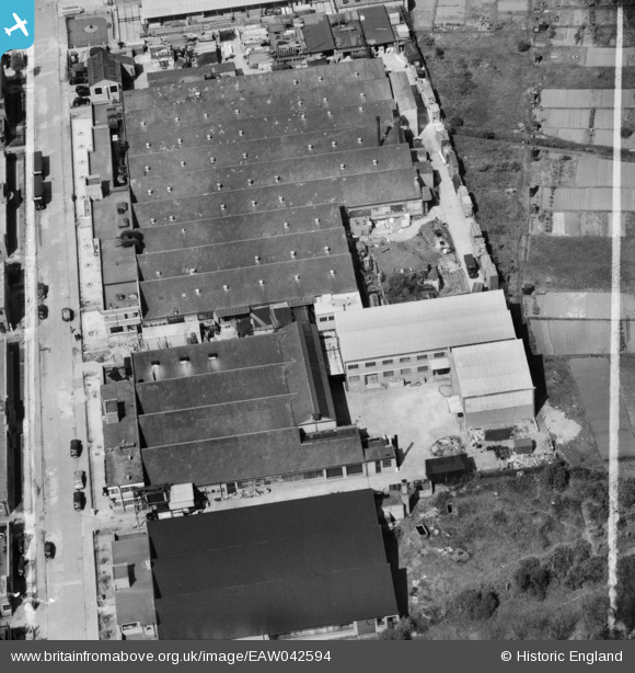
EAW042594 ENGLAND (1952). Factories on Argall Avenue including the M. Saper Ltd Confectionery Works, Leyton, 1952. This image was marked by Aerofilms Ltd for photo editing.
© Copyright OpenStreetMap contributors and licensed by the OpenStreetMap Foundation. 2026. Cartography is licensed as CC BY-SA.
Nearby Images (24)
Details
| Title | [EAW042594] Factories on Argall Avenue including the M. Saper Ltd Confectionery Works, Leyton, 1952. This image was marked by Aerofilms Ltd for photo editing. |
| Reference | EAW042594 |
| Date | 22-April-1952 |
| Link | |
| Place name | LEYTON |
| Parish | |
| District | |
| Country | ENGLAND |
| Easting / Northing | 535851, 187552 |
| Longitude / Latitude | -0.039574033979816, 51.56997496808 |
| National Grid Reference | TQ359876 |
Pins
Be the first to add a comment to this image!


![[EAW042594] Factories on Argall Avenue including the M. Saper Ltd Confectionery Works, Leyton, 1952. This image was marked by Aerofilms Ltd for photo editing.](http://britainfromabove.org.uk/sites/all/libraries/aerofilms-images/public/100x100/EAW/042/EAW042594.jpg)
![[EAW042593] M. Saper Ltd Confectionery Works on Argall Avenue, Leyton, 1952. This image was marked by Aerofilms Ltd for photo editing.](http://britainfromabove.org.uk/sites/all/libraries/aerofilms-images/public/100x100/EAW/042/EAW042593.jpg)
![[EAW042598] M. Saper Ltd Confectionery Works on Argall Avenue, Leyton, 1952. This image was marked by Aerofilms Ltd for photo editing.](http://britainfromabove.org.uk/sites/all/libraries/aerofilms-images/public/100x100/EAW/042/EAW042598.jpg)
![[EAW042592] M. Saper Ltd Confectionery Works on Argall Avenue, Leyton, 1952. This image was marked by Aerofilms Ltd for photo editing.](http://britainfromabove.org.uk/sites/all/libraries/aerofilms-images/public/100x100/EAW/042/EAW042592.jpg)
![[EAW042595] M. Saper Ltd Confectionery Works on Argall Avenue, Leyton, 1952. This image was marked by Aerofilms Ltd for photo editing.](http://britainfromabove.org.uk/sites/all/libraries/aerofilms-images/public/100x100/EAW/042/EAW042595.jpg)
![[EAW042599] M. Saper Ltd Confectionery Works on Argall Avenue, Leyton, 1952. This image was marked by Aerofilms Ltd for photo editing.](http://britainfromabove.org.uk/sites/all/libraries/aerofilms-images/public/100x100/EAW/042/EAW042599.jpg)
![[EAW042264] Factories on Argall Avenue, Leyton, 1952. This image was marked by Aerofilms Ltd for photo editing.](http://britainfromabove.org.uk/sites/all/libraries/aerofilms-images/public/100x100/EAW/042/EAW042264.jpg)
![[EAW042597] M. Saper Ltd Confectionery Works on Argall Avenue, Leyton, 1952. This image was marked by Aerofilms Ltd for photo editing.](http://britainfromabove.org.uk/sites/all/libraries/aerofilms-images/public/100x100/EAW/042/EAW042597.jpg)
![[EAW042263] Factories on Argall Avenue, Leyton, 1952. This image was marked by Aerofilms Ltd for photo editing.](http://britainfromabove.org.uk/sites/all/libraries/aerofilms-images/public/100x100/EAW/042/EAW042263.jpg)
![[EAW042596] M. Saper Ltd Confectionery Works on Argall Avenue, Leyton, 1952. This image was marked by Aerofilms Ltd for photo editing.](http://britainfromabove.org.uk/sites/all/libraries/aerofilms-images/public/100x100/EAW/042/EAW042596.jpg)
![[EAW042266] Factories on Argall Avenue, Leyton, 1952. This image was marked by Aerofilms Ltd for photo editing.](http://britainfromabove.org.uk/sites/all/libraries/aerofilms-images/public/100x100/EAW/042/EAW042266.jpg)
![[EAW042600] Factories on Argall Avenue including the M. Saper Ltd Confectionery Works, Leyton, 1952. This image was marked by Aerofilms Ltd for photo editing.](http://britainfromabove.org.uk/sites/all/libraries/aerofilms-images/public/100x100/EAW/042/EAW042600.jpg)
![[EAW042265] Factories on Argall Avenue, Leyton, 1952. This image was marked by Aerofilms Ltd for photo editing.](http://britainfromabove.org.uk/sites/all/libraries/aerofilms-images/public/100x100/EAW/042/EAW042265.jpg)
![[EAW042260] Factories on Argall Avenue, Leyton, 1952. This image was marked by Aerofilms Ltd for photo editing.](http://britainfromabove.org.uk/sites/all/libraries/aerofilms-images/public/100x100/EAW/042/EAW042260.jpg)
![[EAW042261] Factories on Argall Avenue, Leyton, 1952. This image was marked by Aerofilms Ltd for photo editing.](http://britainfromabove.org.uk/sites/all/libraries/aerofilms-images/public/100x100/EAW/042/EAW042261.jpg)
![[EAW042262] Factories on Argall Avenue, Leyton, 1952. This image was marked by Aerofilms Ltd for photo editing.](http://britainfromabove.org.uk/sites/all/libraries/aerofilms-images/public/100x100/EAW/042/EAW042262.jpg)
![[EAW025319] F. Austin Leyton Ltd Furniture Works on Argall Avenue, Leyton, 1949](http://britainfromabove.org.uk/sites/all/libraries/aerofilms-images/public/100x100/EAW/025/EAW025319.jpg)
![[EAW025321] F. Austin Leyton Ltd Furniture Works and other factories on Argall Avenue, Leyton, 1949](http://britainfromabove.org.uk/sites/all/libraries/aerofilms-images/public/100x100/EAW/025/EAW025321.jpg)
![[EAW025318] F. Austin Leyton Ltd Furniture Works on Argall Avenue, Leyton, 1949](http://britainfromabove.org.uk/sites/all/libraries/aerofilms-images/public/100x100/EAW/025/EAW025318.jpg)
![[EAW025317] F. Austin Leyton Ltd Furniture Works and other factories on Argall Avenue, Leyton, 1949. This image was marked by Aerofilms Ltd for photo editing.](http://britainfromabove.org.uk/sites/all/libraries/aerofilms-images/public/100x100/EAW/025/EAW025317.jpg)
![[EAW025315] F. Austin Leyton Ltd Furniture Works and other factories on Argall Avenue, Leyton, 1949](http://britainfromabove.org.uk/sites/all/libraries/aerofilms-images/public/100x100/EAW/025/EAW025315.jpg)
![[EAW025320] F. Austin Leyton Ltd Furniture Works on Argall Avenue, Leyton, 1949. This image was marked by Aerofilms Ltd for photo editing.](http://britainfromabove.org.uk/sites/all/libraries/aerofilms-images/public/100x100/EAW/025/EAW025320.jpg)
![[EAW025322] F. Austin Leyton Ltd Furniture Works on Argall Avenue, Leyton, 1949](http://britainfromabove.org.uk/sites/all/libraries/aerofilms-images/public/100x100/EAW/025/EAW025322.jpg)
![[EAW025316] F. Austin Leyton Ltd Furniture Works and other factories on Argall Avenue, Leyton, 1949](http://britainfromabove.org.uk/sites/all/libraries/aerofilms-images/public/100x100/EAW/025/EAW025316.jpg)