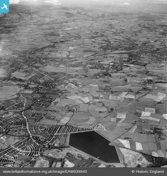
EAW039843 ENGLAND (1951). Heaton Park Reservoir and the town, Whitefield, from the south-east, 1951
© Copyright OpenStreetMap contributors and licensed by the OpenStreetMap Foundation. 2026. Cartography is licensed as CC BY-SA.
Details
| Title | [EAW039843] Heaton Park Reservoir and the town, Whitefield, from the south-east, 1951 |
| Reference | EAW039843 |
| Date | 15-September-1951 |
| Link | |
| Place name | WHITEFIELD |
| Parish | |
| District | |
| Country | ENGLAND |
| Easting / Northing | 382006, 405435 |
| Longitude / Latitude | -2.2715838169311, 53.545001178112 |
| National Grid Reference | SD820054 |
Pins

Moonraker |
Thursday 25th of January 2024 10:14:23 PM | |

Moonraker |
Thursday 25th of January 2024 10:05:58 PM | |

Moonraker |
Thursday 25th of January 2024 10:04:42 PM | |

Moonraker |
Friday 1st of December 2023 04:13:59 PM | |

Moonraker |
Friday 1st of December 2023 04:11:14 PM | |

toecee |
Sunday 19th of September 2021 09:22:42 PM | |

toecee |
Sunday 19th of September 2021 09:19:47 PM | |

toecee |
Sunday 19th of September 2021 09:18:29 PM | |

toecee |
Sunday 19th of September 2021 09:16:52 PM | |

DMalone |
Tuesday 17th of April 2018 10:33:06 AM | |

DMalone |
Tuesday 17th of April 2018 10:30:50 AM | |

DMalone |
Tuesday 17th of April 2018 10:28:52 AM | |

DMalone |
Tuesday 17th of April 2018 10:28:11 AM | |

Barney Rubble |
Friday 29th of April 2016 11:04:15 PM | |

Sloopy |
Monday 28th of March 2016 01:44:56 PM | |

Sloopy |
Monday 28th of March 2016 01:36:07 PM | |

Eddie Ball |
Monday 15th of September 2014 02:26:32 PM | |

boltie |
Wednesday 7th of May 2014 12:13:25 AM | |

boltie |
Monday 5th of May 2014 08:53:19 AM | |

boltie |
Monday 5th of May 2014 08:51:36 AM |


![[EAW039843] Heaton Park Reservoir and the town, Whitefield, from the south-east, 1951](http://britainfromabove.org.uk/sites/all/libraries/aerofilms-images/public/100x100/EAW/039/EAW039843.jpg)
![[EAW039837] Kirkhams and environs, Whitefield, 1951](http://britainfromabove.org.uk/sites/all/libraries/aerofilms-images/public/100x100/EAW/039/EAW039837.jpg)