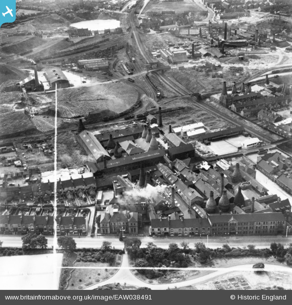
EAW038491 ENGLAND (1951). The Albany and Harvey Potteries and environs, Burslem, 1951. This image has been produced from a print marked by Aerofilms Ltd for photo editing.
© Copyright OpenStreetMap contributors and licensed by the OpenStreetMap Foundation. 2026. Cartography is licensed as CC BY-SA.
Nearby Images (20)
Details
| Title | [EAW038491] The Albany and Harvey Potteries and environs, Burslem, 1951. This image has been produced from a print marked by Aerofilms Ltd for photo editing. |
| Reference | EAW038491 |
| Date | 1-August-1951 |
| Link | |
| Place name | BURSLEM |
| Parish | |
| District | |
| Country | ENGLAND |
| Easting / Northing | 387451, 349884 |
| Longitude / Latitude | -2.1872066126756, 53.045771513348 |
| National Grid Reference | SJ875499 |
Pins
Be the first to add a comment to this image!


![[EAW038491] The Albany and Harvey Potteries and environs, Burslem, 1951. This image has been produced from a print marked by Aerofilms Ltd for photo editing.](http://britainfromabove.org.uk/sites/all/libraries/aerofilms-images/public/100x100/EAW/038/EAW038491.jpg)
![[EAW038486] The Albany and Harvey Potteries alongside Sneyd Colliery, Burslem, 1951. This image has been produced from a print marked by Aerofilms Ltd for photo editing.](http://britainfromabove.org.uk/sites/all/libraries/aerofilms-images/public/100x100/EAW/038/EAW038486.jpg)
![[EAW038485] The Albany and Harvey Potteries, Burslem, 1951. This image has been produced from a print marked by Aerofilms Ltd for photo editing.](http://britainfromabove.org.uk/sites/all/libraries/aerofilms-images/public/100x100/EAW/038/EAW038485.jpg)
![[EAW038487] The Albany and Harvey Potteries off Moorland Road, Burslem, 1951. This image has been produced from a print marked by Aerofilms Ltd for photo editing.](http://britainfromabove.org.uk/sites/all/libraries/aerofilms-images/public/100x100/EAW/038/EAW038487.jpg)
![[EAW001881] The Sneyd Colliery and Brick Works and the surrounding area, Burslem, 1946](http://britainfromabove.org.uk/sites/all/libraries/aerofilms-images/public/100x100/EAW/001/EAW001881.jpg)
![[EAW038488] The Albany and Harvey Potteries and environs, Burslem, 1951. This image has been produced from a print marked by Aerofilms Ltd for photo editing.](http://britainfromabove.org.uk/sites/all/libraries/aerofilms-images/public/100x100/EAW/038/EAW038488.jpg)
![[EPW034084] The Sneyd Colliery and Brick Works, Burslem Park and environs, Burslem, 1930](http://britainfromabove.org.uk/sites/all/libraries/aerofilms-images/public/100x100/EPW/034/EPW034084.jpg)
![[EAW001882] The Sneyd Colliery and Brick Works and the surrounding area, Burslem, 1946](http://britainfromabove.org.uk/sites/all/libraries/aerofilms-images/public/100x100/EAW/001/EAW001882.jpg)
![[EAW001879] The Sneyd Colliery and Brick Works, Burslem, 1946](http://britainfromabove.org.uk/sites/all/libraries/aerofilms-images/public/100x100/EAW/001/EAW001879.jpg)
![[EAW001878] The Sneyd Colliery and Brick Works, Burslem, 1946](http://britainfromabove.org.uk/sites/all/libraries/aerofilms-images/public/100x100/EAW/001/EAW001878.jpg)
![[EAW001885] The Sneyd Colliery and Brick Works, Burslem, 1946](http://britainfromabove.org.uk/sites/all/libraries/aerofilms-images/public/100x100/EAW/001/EAW001885.jpg)
![[EPW034094] The Sneyd Colliery and Brick Works, the China and Earthenware Manufactory and surroundings, Burslem, 1930](http://britainfromabove.org.uk/sites/all/libraries/aerofilms-images/public/100x100/EPW/034/EPW034094.jpg)
![[EAW001884] The Sneyd Colliery and Brick Works, Burslem, 1946](http://britainfromabove.org.uk/sites/all/libraries/aerofilms-images/public/100x100/EAW/001/EAW001884.jpg)
![[EPW034086] The Sneyd Colliery and Brick Works, Burslem Park and surroundings, Burslem, from the south-west, 1930](http://britainfromabove.org.uk/sites/all/libraries/aerofilms-images/public/100x100/EPW/034/EPW034086.jpg)
![[EAW001883] The Sneyd Colliery and Brick Works, Burslem, 1946](http://britainfromabove.org.uk/sites/all/libraries/aerofilms-images/public/100x100/EAW/001/EAW001883.jpg)
![[EAW001880] The Sneyd Colliery and Brick Works and the surrounding area, Burslem, 1946](http://britainfromabove.org.uk/sites/all/libraries/aerofilms-images/public/100x100/EAW/001/EAW001880.jpg)
![[EPW034087] The Sneyd Colliery and Brick Works, the China and Earthenware Manufactory and Burslem Park, Burslem, 1930](http://britainfromabove.org.uk/sites/all/libraries/aerofilms-images/public/100x100/EPW/034/EPW034087.jpg)
![[EAW001877] The Sneyd Colliery and Brick Works, Burslem, 1946](http://britainfromabove.org.uk/sites/all/libraries/aerofilms-images/public/100x100/EAW/001/EAW001877.jpg)
![[EAW001876] The Sneyd Colliery and Brick Works, Burslem, 1946](http://britainfromabove.org.uk/sites/all/libraries/aerofilms-images/public/100x100/EAW/001/EAW001876.jpg)
![[EPW034089] The Sneyd Colliery and Brick Works and surroundings, Burslem, 1930](http://britainfromabove.org.uk/sites/all/libraries/aerofilms-images/public/100x100/EPW/034/EPW034089.jpg)