
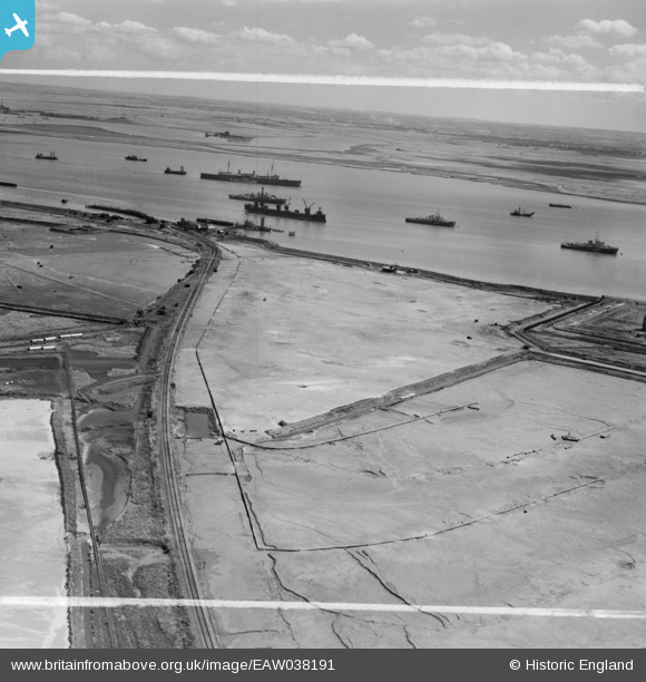
EAW038191 ENGLAND (1951). The Hoo Junction and Port Victoria Railway line and vessels off Port Victoria, Isle of Grain, from the north-west, 1951. This image was marked by Aerofilms Ltd for photo editing.
© Copyright OpenStreetMap contributors and licensed by the OpenStreetMap Foundation. 2026. Cartography is licensed as CC BY-SA.
Nearby Images (3)
EAW038191

EAW048529

EAW045776

Details
| Title | [EAW038191] The Hoo Junction and Port Victoria Railway line and vessels off Port Victoria, Isle of Grain, from the north-west, 1951. This image was marked by Aerofilms Ltd for photo editing. |
| Reference | EAW038191 |
| Date | 2-August-1951 |
| Link | |
| Place name | ISLE OF GRAIN |
| Parish | ISLE OF GRAIN |
| District | |
| Country | ENGLAND |
| Easting / Northing | 587114, 174376 |
| Longitude / Latitude | 0.69243750381741, 51.436941479294 |
| National Grid Reference | TQ871744 |
Pins

redmist |
Monday 24th of January 2022 08:21:35 PM | |
|
redmist |
Monday 24th of January 2022 08:03:53 PM | |

Matt Aldred edob.mattaldred.com |
Sunday 16th of May 2021 08:37:56 PM | |
|
Matt Aldred edob.mattaldred.com |
Sunday 16th of May 2021 08:37:23 PM | |
|
Matt Aldred edob.mattaldred.com |
Sunday 16th of May 2021 08:36:56 PM | |
|
redmist |
Sunday 21st of June 2020 10:14:48 PM | |
|
redmist |
Sunday 21st of June 2020 10:13:56 PM | |
|
Kentishman |
Thursday 28th of July 2016 01:26:56 PM |
User Comment Contributions
Does anyone know which decommissioned and gutted Great War Warship provided the hull for that coal Hulk? The ram-bow shows the ship was a pre-Great War warship design. My dad used to say it was HMS Thunderer - but she was scrapped up in Blyth in the mid 1920's. The ship in the background was HMS Maidstone, 497 ft long, - and the coaling hulk is obviously shorter than that so maybe it wasn't a battleship hull at all but a decomissioned Gt. War Cruiser? |
bargee1937 |
Saturday 18th of July 2015 05:16:26 PM |