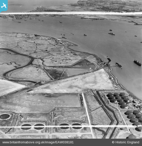
EAW038181 ENGLAND (1951). Horseshoe Point, the River Medway and environs, Isle of Grain, 1951. This image has been produced from a print marked by Aerofilms Ltd for photo editing.
© Copyright OpenStreetMap contributors and licensed by the OpenStreetMap Foundation. 2026. Cartography is licensed as CC BY-SA.
Details
| Title | [EAW038181] Horseshoe Point, the River Medway and environs, Isle of Grain, 1951. This image has been produced from a print marked by Aerofilms Ltd for photo editing. |
| Reference | EAW038181 |
| Date | 2-August-1951 |
| Link | |
| Place name | ISLE OF GRAIN |
| Parish | ISLE OF GRAIN |
| District | |
| Country | ENGLAND |
| Easting / Northing | 587923, 174405 |
| Longitude / Latitude | 0.70407992717331, 51.436934182756 |
| National Grid Reference | TQ879744 |
Pins

redmist |
Sunday 23rd of January 2022 10:15:04 PM | |

redmist |
Sunday 23rd of January 2022 10:11:08 PM | |

redmist |
Sunday 23rd of January 2022 10:09:14 PM | |

redmist |
Sunday 23rd of January 2022 10:06:21 PM | |

redmist |
Sunday 23rd of January 2022 09:58:58 PM | |

redmist |
Sunday 23rd of January 2022 09:56:50 PM | |

The Laird |
Sunday 24th of July 2016 01:23:53 PM | |

Kentishman |
Friday 22nd of July 2016 02:31:10 PM | |

Kentishman |
Friday 22nd of July 2016 02:26:25 PM | |

Kentishman |
Friday 22nd of July 2016 09:09:55 AM | |

Brightonboy |
Thursday 21st of July 2016 09:07:00 PM | |

Kentishman |
Thursday 21st of July 2016 08:26:57 PM | |

Kentishman |
Thursday 21st of July 2016 07:02:40 PM | |

Kentishman |
Thursday 21st of July 2016 06:54:12 PM |


![[EAW038181] Horseshoe Point, the River Medway and environs, Isle of Grain, 1951. This image has been produced from a print marked by Aerofilms Ltd for photo editing.](http://britainfromabove.org.uk/sites/all/libraries/aerofilms-images/public/100x100/EAW/038/EAW038181.jpg)
![[EAW045759] The Anglo-Iranian Oil Co Ltd Kent Oil Refinery under construction, Isle of Grain, from the south-east, 1952](http://britainfromabove.org.uk/sites/all/libraries/aerofilms-images/public/100x100/EAW/045/EAW045759.jpg)
![[EAW038192] The Old Salt Works at Stan Marsh and vessels off Port Victoria, Isle of Grain, from the north, 1951. This image was marked by Aerofilms Ltd for photo editing.](http://britainfromabove.org.uk/sites/all/libraries/aerofilms-images/public/100x100/EAW/038/EAW038192.jpg)