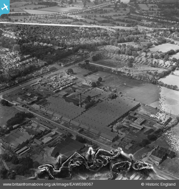
EAW038067 ENGLAND (1951). The Shirley Cabinet Factory, Solihull, 1951. This image has been produced from a damaged negative.
© Copyright OpenStreetMap contributors and licensed by the OpenStreetMap Foundation. 2024. Cartography is licensed as CC BY-SA.
Nearby Images (10)
Details
| Title | [EAW038067] The Shirley Cabinet Factory, Solihull, 1951. This image has been produced from a damaged negative. |
| Reference | EAW038067 |
| Date | 24-July-1951 |
| Link | |
| Place name | SOLIHULL |
| Parish | |
| District | |
| Country | ENGLAND |
| Easting / Northing | 413300, 277985 |
| Longitude / Latitude | -1.8045021057436, 52.399339237549 |
| National Grid Reference | SP133780 |
Pins
Be the first to add a comment to this image!


![[EAW038067] The Shirley Cabinet Factory, Solihull, 1951. This image has been produced from a damaged negative.](http://britainfromabove.org.uk/sites/all/libraries/aerofilms-images/public/100x100/EAW/038/EAW038067.jpg)
![[EAW038072] The Shirley Cabinet Factory, Solihull, 1951. This image has been produced from a print. marked by Aerofilms Ltd for photo editing](http://britainfromabove.org.uk/sites/all/libraries/aerofilms-images/public/100x100/EAW/038/EAW038072.jpg)
![[EAW038062] The Shirley Cabinet Factory, Solihull, 1951. This image was marked by Aerofilms Ltd for photo editing.](http://britainfromabove.org.uk/sites/all/libraries/aerofilms-images/public/100x100/EAW/038/EAW038062.jpg)
![[EAW038063] The Shirley Cabinet Factory, Solihull, 1951. This image was marked by Aerofilms Ltd for photo editing.](http://britainfromabove.org.uk/sites/all/libraries/aerofilms-images/public/100x100/EAW/038/EAW038063.jpg)
![[EAW038071] The Shirley Cabinet Factory, Solihull, 1951. This image has been produced from a print. marked by Aerofilms Ltd for photo editing](http://britainfromabove.org.uk/sites/all/libraries/aerofilms-images/public/100x100/EAW/038/EAW038071.jpg)
![[EAW038070] The Shirley Cabinet Factory, Solihull, 1951. This image has been produced from a print. marked by Aerofilms Ltd for photo editing](http://britainfromabove.org.uk/sites/all/libraries/aerofilms-images/public/100x100/EAW/038/EAW038070.jpg)
![[EAW038064] The Shirley Cabinet Factory, Solihull, 1951. This image has been produced from a damaged negative.](http://britainfromabove.org.uk/sites/all/libraries/aerofilms-images/public/100x100/EAW/038/EAW038064.jpg)
![[EAW038066] The Shirley Cabinet Factory, Solihull, 1951. This image has been produced from a damaged negative.](http://britainfromabove.org.uk/sites/all/libraries/aerofilms-images/public/100x100/EAW/038/EAW038066.jpg)
![[EAW038061] The Shirley Cabinet Factory, Solihull, 1951. This image was marked by Aerofilms Ltd for photo editing.](http://britainfromabove.org.uk/sites/all/libraries/aerofilms-images/public/100x100/EAW/038/EAW038061.jpg)
![[EAW038065] The Shirley Cabinet Factory, Solihull, 1951. This image has been produced from a damaged negative.](http://britainfromabove.org.uk/sites/all/libraries/aerofilms-images/public/100x100/EAW/038/EAW038065.jpg)