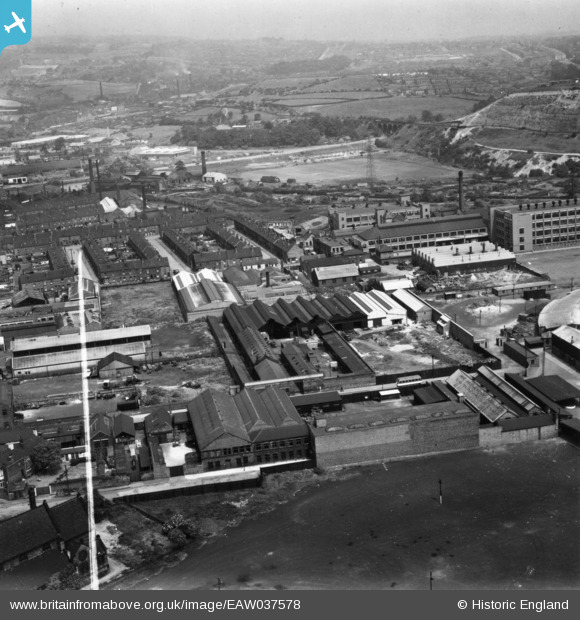
EAW037578 ENGLAND (1951). The G. W. Thornton Cutlery Works off Lowther Road, Owlerton, from the south, 1951. This image has been produced from a print marked by Aerofilms Ltd for photo editing.
© Copyright OpenStreetMap contributors and licensed by the OpenStreetMap Foundation. 2026. Cartography is licensed as CC BY-SA.
Nearby Images (23)
Details
| Title | [EAW037578] The G. W. Thornton Cutlery Works off Lowther Road, Owlerton, from the south, 1951. This image has been produced from a print marked by Aerofilms Ltd for photo editing. |
| Reference | EAW037578 |
| Date | 30-June-1951 |
| Link | |
| Place name | OWLERTON |
| Parish | |
| District | |
| Country | ENGLAND |
| Easting / Northing | 433680, 390021 |
| Longitude / Latitude | -1.4933280886032, 53.405670576038 |
| National Grid Reference | SK337900 |
Pins
Be the first to add a comment to this image!


![[EAW037578] The G. W. Thornton Cutlery Works off Lowther Road, Owlerton, from the south, 1951. This image has been produced from a print marked by Aerofilms Ltd for photo editing.](http://britainfromabove.org.uk/sites/all/libraries/aerofilms-images/public/100x100/EAW/037/EAW037578.jpg)
![[EAW037583] The G. W. Thornton Cutlery Works off Lowther Road, Owlerton, 1951. This image has been produced from a print marked by Aerofilms Ltd for photo editing.](http://britainfromabove.org.uk/sites/all/libraries/aerofilms-images/public/100x100/EAW/037/EAW037583.jpg)
![[EAW037580] The G. W. Thornton Cutlery Works off Lowther Road, Owlerton, 1951. This image has been produced from a print marked by Aerofilms Ltd for photo editing.](http://britainfromabove.org.uk/sites/all/libraries/aerofilms-images/public/100x100/EAW/037/EAW037580.jpg)
![[EAW037579] The G. W. Thornton Cutlery Works off Lowther Road, Owlerton, 1951. This image has been produced from a print marked by Aerofilms Ltd for photo editing.](http://britainfromabove.org.uk/sites/all/libraries/aerofilms-images/public/100x100/EAW/037/EAW037579.jpg)
![[EAW037584] The G. W. Thornton Cutlery Works off Lowther Road, Owlerton, 1951. This image has been produced from a print marked by Aerofilms Ltd for photo editing.](http://britainfromabove.org.uk/sites/all/libraries/aerofilms-images/public/100x100/EAW/037/EAW037584.jpg)
![[EAW037582] The G. W. Thornton Cutlery Works off Lowther Road, Owlerton, 1951. This image has been produced from a print marked by Aerofilms Ltd for photo editing.](http://britainfromabove.org.uk/sites/all/libraries/aerofilms-images/public/100x100/EAW/037/EAW037582.jpg)
![[EAW037576] The G. W. Thornton Cutlery Works off Lowther Road, Owlerton, 1951. This image has been produced from a print marked by Aerofilms Ltd for photo editing.](http://britainfromabove.org.uk/sites/all/libraries/aerofilms-images/public/100x100/EAW/037/EAW037576.jpg)
![[EAW037581] The G. W. Thornton Cutlery Works off Lowther Road and Owlerton Stadium, Owlerton, 1951. This image has been produced from a print marked by Aerofilms Ltd for photo editing.](http://britainfromabove.org.uk/sites/all/libraries/aerofilms-images/public/100x100/EAW/037/EAW037581.jpg)
![[EAW037577] The G. W. Thornton Cutlery Works off Lowther Road and the George Bassett and Co Ltd Confectionery Works, Owlerton, 1951. This image has been produced from a print marked by Aerofilms Ltd for photo editing.](http://britainfromabove.org.uk/sites/all/libraries/aerofilms-images/public/100x100/EAW/037/EAW037577.jpg)
![[EAW040039] The W. Smith & Co Steel Wire Works, Owlerton, 1951. This image has been produced from a damaged negative.](http://britainfromabove.org.uk/sites/all/libraries/aerofilms-images/public/100x100/EAW/040/EAW040039.jpg)
![[EAW040034] The W. Smith & Co Steel Wire Works, Owlerton, 1951. This image was marked by Aerofilms Ltd for photo editing.](http://britainfromabove.org.uk/sites/all/libraries/aerofilms-images/public/100x100/EAW/040/EAW040034.jpg)
![[EAW040037] The W. Smith & Co Steel Wire Works, Owlerton, 1951. This image was marked by Aerofilms Ltd for photo editing.](http://britainfromabove.org.uk/sites/all/libraries/aerofilms-images/public/100x100/EAW/040/EAW040037.jpg)
![[EAW040035] The W. Smith & Co Steel Wire Works and adjacent housing off Beulah Road, Owlerton, 1951. This image was marked by Aerofilms Ltd for photo editing.](http://britainfromabove.org.uk/sites/all/libraries/aerofilms-images/public/100x100/EAW/040/EAW040035.jpg)
![[EAW040038] The W. Smith & Co Steel Wire Works, Owlerton, 1951. This image was marked by Aerofilms Ltd for photo editing.](http://britainfromabove.org.uk/sites/all/libraries/aerofilms-images/public/100x100/EAW/040/EAW040038.jpg)
![[EAW040036] The W. Smith & Co Steel Wire Works and the George Bassett and Co Ltd Confectionary Works, Owlerton, 1951. This image was marked by Aerofilms Ltd for photo editing.](http://britainfromabove.org.uk/sites/all/libraries/aerofilms-images/public/100x100/EAW/040/EAW040036.jpg)
![[EAW028028] George Bassett and Co Ltd Confectionery Works (Bassetts Liquorice Allsorts), Owlerton, 1950. This image has been produced from a print marked by Aerofilms Ltd for photo editing.](http://britainfromabove.org.uk/sites/all/libraries/aerofilms-images/public/100x100/EAW/028/EAW028028.jpg)
![[EAW028027] George Bassett and Co Ltd Confectionery Works (Bassetts Liquorice Allsorts), Owlerton, 1950. This image has been produced from a print marked by Aerofilms Ltd for photo editing.](http://britainfromabove.org.uk/sites/all/libraries/aerofilms-images/public/100x100/EAW/028/EAW028027.jpg)
![[EPW048672] George Bassett and Co Ltd Confectionery Works and the Sports Stadium at Owlerton, Sheffield, 1935](http://britainfromabove.org.uk/sites/all/libraries/aerofilms-images/public/100x100/EPW/048/EPW048672.jpg)
![[EAW028021] George Bassett and Co Ltd Confectionery Works (Bassetts Liquorice Allsorts), Owlerton, 1950. This image has been produced from a damaged negative.](http://britainfromabove.org.uk/sites/all/libraries/aerofilms-images/public/100x100/EAW/028/EAW028021.jpg)
![[EAW028029] George Bassett and Co Ltd Confectionery Works (Bassetts Liquorice Allsorts), Owlerton, 1950. This image has been produced from a print marked by Aerofilms Ltd for photo editing.](http://britainfromabove.org.uk/sites/all/libraries/aerofilms-images/public/100x100/EAW/028/EAW028029.jpg)
![[EAW028023] George Bassett and Co Ltd Confectionery Works (Bassetts Liquorice Allsorts), Owlerton, 1950. This image has been produced from a print marked by Aerofilms Ltd for photo editing.](http://britainfromabove.org.uk/sites/all/libraries/aerofilms-images/public/100x100/EAW/028/EAW028023.jpg)
![[EPW048669] George Bassett and Co Ltd Confectionery Works at Owlerton, Sheffield, 1935](http://britainfromabove.org.uk/sites/all/libraries/aerofilms-images/public/100x100/EPW/048/EPW048669.jpg)
![[EPW048668] George Bassett and Co Ltd Confectionery Works at Owlerton, Sheffield, 1935](http://britainfromabove.org.uk/sites/all/libraries/aerofilms-images/public/100x100/EPW/048/EPW048668.jpg)