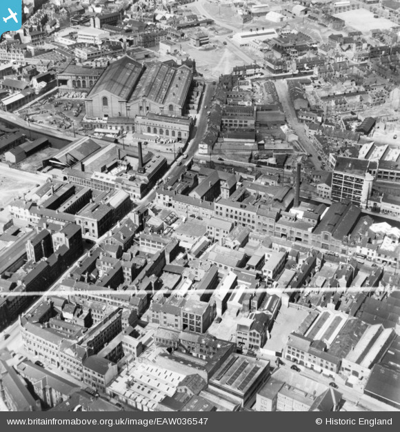
EAW036547 ENGLAND (1951). Princip Street, Lower Loveday Street and environs, Birmingham, 1951. This image has been produced from a print marked by Aerofilms Ltd for photo editing.
© Copyright OpenStreetMap contributors and licensed by the OpenStreetMap Foundation. 2026. Cartography is licensed as CC BY-SA.
Nearby Images (11)
Details
| Title | [EAW036547] Princip Street, Lower Loveday Street and environs, Birmingham, 1951. This image has been produced from a print marked by Aerofilms Ltd for photo editing. |
| Reference | EAW036547 |
| Date | 31-May-1951 |
| Link | |
| Place name | BIRMINGHAM |
| Parish | |
| District | |
| Country | ENGLAND |
| Easting / Northing | 407137, 287718 |
| Longitude / Latitude | -1.8948842855996, 52.48696420457 |
| National Grid Reference | SP071877 |
Pins

Elskidis |
Friday 6th of May 2022 05:52:24 PM | |

Matt Aldred edob.mattaldred.com |
Sunday 30th of January 2022 05:08:01 PM | |

Billy Turner |
Sunday 6th of November 2016 07:39:06 PM |


![[EAW036547] Princip Street, Lower Loveday Street and environs, Birmingham, 1951. This image has been produced from a print marked by Aerofilms Ltd for photo editing.](http://britainfromabove.org.uk/sites/all/libraries/aerofilms-images/public/100x100/EAW/036/EAW036547.jpg)
![[EAW036554] Factories along Princip Street, Birmingham, 1951. This image has been produced from a print marked by Aerofilms Ltd for photo editing.](http://britainfromabove.org.uk/sites/all/libraries/aerofilms-images/public/100x100/EAW/036/EAW036554.jpg)
![[EAW036544] Shadwell Street, Princip Street, the Birmingham and Fazeley Canal and environs, Birmingham, 1951. This image has been produced from a print marked by Aerofilms Ltd for photo editing.](http://britainfromabove.org.uk/sites/all/libraries/aerofilms-images/public/100x100/EAW/036/EAW036544.jpg)
![[EAW036549] Wire Mill on Shadwell Street next to Barker Bridge, Birmingham, 1951. This image has been produced from a print marked by Aerofilms Ltd for photo editing.](http://britainfromabove.org.uk/sites/all/libraries/aerofilms-images/public/100x100/EAW/036/EAW036549.jpg)
![[EAW036551] Wire Mill on Shadwell Street, Lower Loveday Street and environs, Birmingham, 1951. This image has been produced from a print marked by Aerofilms Ltd for photo editing.](http://britainfromabove.org.uk/sites/all/libraries/aerofilms-images/public/100x100/EAW/036/EAW036551.jpg)
![[EAW036550] Wire Mill and adjacent garage on Shadwell Street, Birmingham, 1951. This image has been produced from a print marked by Aerofilms Ltd for photo editing.](http://britainfromabove.org.uk/sites/all/libraries/aerofilms-images/public/100x100/EAW/036/EAW036550.jpg)
![[EAW036546] Shadwell Street, Princip Street, Cliveland Street and environs, Birmingham, from the south-east, 1951. This image has been produced from a print marked by Aerofilms Ltd for photo editing.](http://britainfromabove.org.uk/sites/all/libraries/aerofilms-images/public/100x100/EAW/036/EAW036546.jpg)
![[EAW036552] Factories along Princip Street and the Birmingham and Fazeley Canal, Birmingham, 1951. This image has been produced from a print marked by Aerofilms Ltd for photo editing.](http://britainfromabove.org.uk/sites/all/libraries/aerofilms-images/public/100x100/EAW/036/EAW036552.jpg)
![[EPW005848] St Mary's Church, the General Hospital and Electric Supply Station, Birmingham, 1921](http://britainfromabove.org.uk/sites/all/libraries/aerofilms-images/public/100x100/EPW/005/EPW005848.jpg)
![[EPW038605] The General Hospital, Birmingham, 1932](http://britainfromabove.org.uk/sites/all/libraries/aerofilms-images/public/100x100/EPW/038/EPW038605.jpg)
![[EPW005847] St Mary's Church and General Hospital off Whittall Street, Birmingham, 1921](http://britainfromabove.org.uk/sites/all/libraries/aerofilms-images/public/100x100/EPW/005/EPW005847.jpg)
