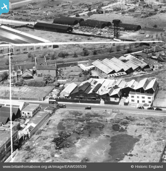
EAW036539 ENGLAND (1951). Drop Stamping Works on Birch Road, Witton, 1951. This image has been produced from a print marked by Aerofilms Ltd for photo editing.
© Copyright OpenStreetMap contributors and licensed by the OpenStreetMap Foundation. 2026. Cartography is licensed as CC BY-SA.
Nearby Images (17)
Details
| Title | [EAW036539] Drop Stamping Works on Birch Road, Witton, 1951. This image has been produced from a print marked by Aerofilms Ltd for photo editing. |
| Reference | EAW036539 |
| Date | 31-May-1951 |
| Link | |
| Place name | WITTON |
| Parish | |
| District | |
| Country | ENGLAND |
| Easting / Northing | 408300, 290919 |
| Longitude / Latitude | -1.8776754835641, 52.515727793793 |
| National Grid Reference | SP083909 |
Pins
Be the first to add a comment to this image!


![[EAW036539] Drop Stamping Works on Birch Road, Witton, 1951. This image has been produced from a print marked by Aerofilms Ltd for photo editing.](http://britainfromabove.org.uk/sites/all/libraries/aerofilms-images/public/100x100/EAW/036/EAW036539.jpg)
![[EAW035736] Drop Stamping Co Ltd Works off Birch Road and environs, Witton, 1951. This image has been produced from a print marked by Aerofilms Ltd for photo editing.](http://britainfromabove.org.uk/sites/all/libraries/aerofilms-images/public/100x100/EAW/035/EAW035736.jpg)
![[EAW035732] Drop Stamping Co Ltd Works off Birch Road, Witton, 1951. This image has been produced from a print marked by Aerofilms Ltd for photo editing.](http://britainfromabove.org.uk/sites/all/libraries/aerofilms-images/public/100x100/EAW/035/EAW035732.jpg)
![[EAW035737] Drop Stamping Co Ltd Works off Birch Road and environs, Witton, 1951. This image has been produced from a print marked by Aerofilms Ltd for photo editing.](http://britainfromabove.org.uk/sites/all/libraries/aerofilms-images/public/100x100/EAW/035/EAW035737.jpg)
![[EAW036534] Drop Stamping Works on Birch Road, Witton, 1951. This image has been produced from a print marked by Aerofilms Ltd for photo editing.](http://britainfromabove.org.uk/sites/all/libraries/aerofilms-images/public/100x100/EAW/036/EAW036534.jpg)
![[EAW036536] Drop Stamping Works on Birch Road, Witton, 1951. This image has been produced from a print marked by Aerofilms Ltd for photo editing.](http://britainfromabove.org.uk/sites/all/libraries/aerofilms-images/public/100x100/EAW/036/EAW036536.jpg)
![[EAW036535] Drop Stamping Works on Birch Road, Witton, 1951. This image has been produced from a print marked by Aerofilms Ltd for photo editing.](http://britainfromabove.org.uk/sites/all/libraries/aerofilms-images/public/100x100/EAW/036/EAW036535.jpg)
![[EAW035735] Drop Stamping Co Ltd Works off Birch Road and environs, Witton, 1951. This image has been produced from a print marked by Aerofilms Ltd for photo editing.](http://britainfromabove.org.uk/sites/all/libraries/aerofilms-images/public/100x100/EAW/035/EAW035735.jpg)
![[EAW035733] Drop Stamping Co Ltd Works off Birch Road, Witton, 1951. This image has been produced from a print marked by Aerofilms Ltd for photo editing.](http://britainfromabove.org.uk/sites/all/libraries/aerofilms-images/public/100x100/EAW/035/EAW035733.jpg)
![[EAW035731] Drop Stamping Co Ltd Works off Birch Road and environs, Witton, 1951. This image has been produced from a print marked by Aerofilms Ltd for photo editing.](http://britainfromabove.org.uk/sites/all/libraries/aerofilms-images/public/100x100/EAW/035/EAW035731.jpg)
![[EAW035734] Drop Stamping Co Ltd Works off Birch Road, Witton, 1951. This image has been produced from a print marked by Aerofilms Ltd for photo editing.](http://britainfromabove.org.uk/sites/all/libraries/aerofilms-images/public/100x100/EAW/035/EAW035734.jpg)
![[EAW036542] Drop Stamping Works on Birch Road, Witton, 1951. This image has been produced from a print marked by Aerofilms Ltd for photo editing.](http://britainfromabove.org.uk/sites/all/libraries/aerofilms-images/public/100x100/EAW/036/EAW036542.jpg)
![[EPW061749] Higgs Electric Motor Works and environs, Witton, 1939](http://britainfromabove.org.uk/sites/all/libraries/aerofilms-images/public/100x100/EPW/061/EPW061749.jpg)
![[EPW061743] Higgs Electric Motor Works and environs, Witton, 1939](http://britainfromabove.org.uk/sites/all/libraries/aerofilms-images/public/100x100/EPW/061/EPW061743.jpg)
![[EPW061748] Higgs Electric Motor Works, Witton, 1939](http://britainfromabove.org.uk/sites/all/libraries/aerofilms-images/public/100x100/EPW/061/EPW061748.jpg)
![[EPW061747] Higgs Electric Motor Works and environs, Witton, 1939](http://britainfromabove.org.uk/sites/all/libraries/aerofilms-images/public/100x100/EPW/061/EPW061747.jpg)
![[EPW061744] Higgs Electric Motor Works, Witton, 1939](http://britainfromabove.org.uk/sites/all/libraries/aerofilms-images/public/100x100/EPW/061/EPW061744.jpg)