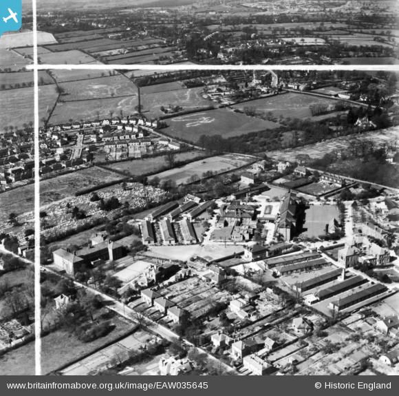
EAW035645 ENGLAND (1951). Barnet General Hospital and environs, Barnet, 1951. This image has been produced from a print marked by Aerofilms Ltd for photo editing.
© Copyright OpenStreetMap contributors and licensed by the OpenStreetMap Foundation. 2025. Cartography is licensed as CC BY-SA.
Nearby Images (12)
Details
| Title | [EAW035645] Barnet General Hospital and environs, Barnet, 1951. This image has been produced from a print marked by Aerofilms Ltd for photo editing. |
| Reference | EAW035645 |
| Date | 25-April-1951 |
| Link | |
| Place name | BARNET |
| Parish | |
| District | |
| Country | ENGLAND |
| Easting / Northing | 523584, 196097 |
| Longitude / Latitude | -0.2134853769466, 51.649599997518 |
| National Grid Reference | TQ236961 |
Pins
 Adrian Hepworth |
Sunday 24th of May 2015 07:33:03 PM |


![[EAW035645] Barnet General Hospital and environs, Barnet, 1951. This image has been produced from a print marked by Aerofilms Ltd for photo editing.](http://britainfromabove.org.uk/sites/all/libraries/aerofilms-images/public/100x100/EAW/035/EAW035645.jpg)
![[EAW035646] Barnet General Hospital and environs, Barnet, from the south-west, 1951. This image has been produced from a print marked by Aerofilms Ltd for photo editing.](http://britainfromabove.org.uk/sites/all/libraries/aerofilms-images/public/100x100/EAW/035/EAW035646.jpg)
![[EAW035638] Barnet General Hospital and environs, Barnet, from the south, 1951. This image was marked by Aerofilms Ltd for photo editing.](http://britainfromabove.org.uk/sites/all/libraries/aerofilms-images/public/100x100/EAW/035/EAW035638.jpg)
![[EAW035642] Barnet General Hospital and environs, Barnet, 1951. This image has been produced from a print marked by Aerofilms Ltd for photo editing.](http://britainfromabove.org.uk/sites/all/libraries/aerofilms-images/public/100x100/EAW/035/EAW035642.jpg)
![[EAW035643] Barnet General Hospital and environs, Barnet, 1951. This image has been produced from a print marked by Aerofilms Ltd for photo editing.](http://britainfromabove.org.uk/sites/all/libraries/aerofilms-images/public/100x100/EAW/035/EAW035643.jpg)
![[EAW035641] Barnet General Hospital and environs, Barnet, 1951. This image has been produced from a print marked by Aerofilms Ltd for photo editing.](http://britainfromabove.org.uk/sites/all/libraries/aerofilms-images/public/100x100/EAW/035/EAW035641.jpg)
![[EAW035639] Barnet General Hospital and environs, Barnet, from the south, 1951. This image was marked by Aerofilms Ltd for photo editing.](http://britainfromabove.org.uk/sites/all/libraries/aerofilms-images/public/100x100/EAW/035/EAW035639.jpg)
![[EAW035647] Barnet General Hospital and environs, Barnet, 1951. This image has been produced from a print marked by Aerofilms Ltd for photo editing.](http://britainfromabove.org.uk/sites/all/libraries/aerofilms-images/public/100x100/EAW/035/EAW035647.jpg)
![[EAW035640] Barnet General Hospital and environs, Barnet, 1951. This image has been produced from a print marked by Aerofilms Ltd for photo editing.](http://britainfromabove.org.uk/sites/all/libraries/aerofilms-images/public/100x100/EAW/035/EAW035640.jpg)
![[EAW035648] Barnet General Hospital and environs, Barnet, 1951. This image has been produced from a print marked by Aerofilms Ltd for photo editing.](http://britainfromabove.org.uk/sites/all/libraries/aerofilms-images/public/100x100/EAW/035/EAW035648.jpg)
![[EAW035644] Barnet General Hospital and environs, Barnet, from the south, 1951. This image has been produced from a print marked by Aerofilms Ltd for photo editing.](http://britainfromabove.org.uk/sites/all/libraries/aerofilms-images/public/100x100/EAW/035/EAW035644.jpg)
![[EPW025445] The Wellhouse Hospital Nurses' Home, Barnet, 1928](http://britainfromabove.org.uk/sites/all/libraries/aerofilms-images/public/100x100/EPW/025/EPW025445.jpg)