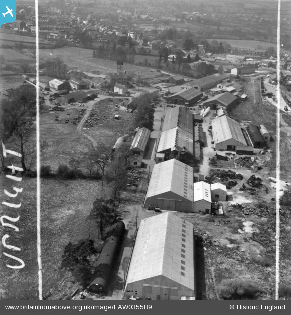
EAW035589 ENGLAND (1951). Engineering Works off Tapstone Lane, Chard, 1951. This image has been produced from a print marked by Aerofilms Ltd for photo editing.
© Copyright OpenStreetMap contributors and licensed by the OpenStreetMap Foundation. 2026. Cartography is licensed as CC BY-SA.
Nearby Images (10)
Details
| Title | [EAW035589] Engineering Works off Tapstone Lane, Chard, 1951. This image has been produced from a print marked by Aerofilms Ltd for photo editing. |
| Reference | EAW035589 |
| Date | 25-April-1951 |
| Link | |
| Place name | CHARD |
| Parish | CHARD TOWN |
| District | |
| Country | ENGLAND |
| Easting / Northing | 333118, 108511 |
| Longitude / Latitude | -2.9506281097918, 50.871669296116 |
| National Grid Reference | ST331085 |
Pins

Charles Dale |
Sunday 7th of June 2015 09:06:17 PM | |

Charles Dale |
Sunday 7th of June 2015 06:50:02 PM |


![[EAW035589] Engineering Works off Tapstone Lane, Chard, 1951. This image has been produced from a print marked by Aerofilms Ltd for photo editing.](http://britainfromabove.org.uk/sites/all/libraries/aerofilms-images/public/100x100/EAW/035/EAW035589.jpg)
![[EAW035593] Engineering Works off Tapstone Lane, Chard, 1951. This image has been produced from a print marked by Aerofilms Ltd for photo editing.](http://britainfromabove.org.uk/sites/all/libraries/aerofilms-images/public/100x100/EAW/035/EAW035593.jpg)
![[EAW035598] Engineering Works off Tapstone Lane, Chard, 1951. This image has been produced from a print marked by Aerofilms Ltd for photo editing.](http://britainfromabove.org.uk/sites/all/libraries/aerofilms-images/public/100x100/EAW/035/EAW035598.jpg)
![[EAW035591] Engineering Works off Tapstone Lane, Chard, 1951. This image has been produced from a print marked by Aerofilms Ltd for photo editing.](http://britainfromabove.org.uk/sites/all/libraries/aerofilms-images/public/100x100/EAW/035/EAW035591.jpg)
![[EAW035596] Engineering Works off Tapstone Lane, Chard, 1951. This image has been produced from a print marked by Aerofilms Ltd for photo editing.](http://britainfromabove.org.uk/sites/all/libraries/aerofilms-images/public/100x100/EAW/035/EAW035596.jpg)
![[EAW035595] Engineering Works off Tapstone Lane, Chard, 1951. This image has been produced from a print marked by Aerofilms Ltd for photo editing.](http://britainfromabove.org.uk/sites/all/libraries/aerofilms-images/public/100x100/EAW/035/EAW035595.jpg)
![[EAW035594] Engineering Works off Tapstone Lane, Chard, 1951. This image has been produced from a print marked by Aerofilms Ltd for photo editing.](http://britainfromabove.org.uk/sites/all/libraries/aerofilms-images/public/100x100/EAW/035/EAW035594.jpg)
![[EAW035590] Engineering Works off Tapstone Lane, Chard, 1951. This image has been produced from a print marked by Aerofilms Ltd for photo editing.](http://britainfromabove.org.uk/sites/all/libraries/aerofilms-images/public/100x100/EAW/035/EAW035590.jpg)
![[EAW035592] Engineering Works off Tapstone Lane, Chard, 1951. This image has been produced from a print marked by Aerofilms Ltd for photo editing.](http://britainfromabove.org.uk/sites/all/libraries/aerofilms-images/public/100x100/EAW/035/EAW035592.jpg)
![[EAW035588] Engineering Works off Tapstone Lane, Chard, from the north-west, 1951. This image has been produced from a print marked by Aerofilms Ltd for photo editing.](http://britainfromabove.org.uk/sites/all/libraries/aerofilms-images/public/100x100/EAW/035/EAW035588.jpg)