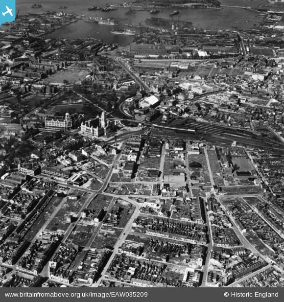
EAW035209 ENGLAND (1951). The city centre, Portsmouth, 1951. This image has been produced from a print.
© Copyright OpenStreetMap contributors and licensed by the OpenStreetMap Foundation. 2026. Cartography is licensed as CC BY-SA.
Nearby Images (10)
Details
| Title | [EAW035209] The city centre, Portsmouth, 1951. This image has been produced from a print. |
| Reference | EAW035209 |
| Date | 6-April-1951 |
| Link | |
| Place name | PORTSMOUTH |
| Parish | |
| District | |
| Country | ENGLAND |
| Easting / Northing | 464144, 100139 |
| Longitude / Latitude | -1.0897487669728, 50.79669539913 |
| National Grid Reference | SU641001 |


![[EAW035209] The city centre, Portsmouth, 1951. This image has been produced from a print.](http://britainfromabove.org.uk/sites/all/libraries/aerofilms-images/public/100x100/EAW/035/EAW035209.jpg)
![[EAW037866] The Guildhall and environs, Portsmouth, 1951. This image has been produced from a print.](http://britainfromabove.org.uk/sites/all/libraries/aerofilms-images/public/100x100/EAW/037/EAW037866.jpg)
![[EAW035208] The city centre, Portsmouth, 1951. This image has been produced from a print.](http://britainfromabove.org.uk/sites/all/libraries/aerofilms-images/public/100x100/EAW/035/EAW035208.jpg)
![[EAW037867] The Guildhall and environs, Portsmouth, 1951. This image has been produced from a print.](http://britainfromabove.org.uk/sites/all/libraries/aerofilms-images/public/100x100/EAW/037/EAW037867.jpg)
![[EAW037865] The Guildhall, Park Building and the surrounding area, Portsmouth, 1951. This image has been produced from a print.](http://britainfromabove.org.uk/sites/all/libraries/aerofilms-images/public/100x100/EAW/037/EAW037865.jpg)
![[EAW035213] The Town Railway Station and environs, Portsmouth, 1951. This image has been produced from a print.](http://britainfromabove.org.uk/sites/all/libraries/aerofilms-images/public/100x100/EAW/035/EAW035213.jpg)
![[EAW035212] The city centre, Portsmouth, 1951. This image has been produced from a print.](http://britainfromabove.org.uk/sites/all/libraries/aerofilms-images/public/100x100/EAW/035/EAW035212.jpg)
![[EAW035214] The city centre and Portsmouth Harbour, Portsmouth, from the south-east, 1951. This image has been produced from a print.](http://britainfromabove.org.uk/sites/all/libraries/aerofilms-images/public/100x100/EAW/035/EAW035214.jpg)
![[EAW405019] The city centre and environs, Portsmouth, 1981](http://britainfromabove.org.uk/sites/all/libraries/aerofilms-images/public/100x100/EAW/405/EAW405019.jpg)
![[EAW035215] The city centre, Portsmouth, 1951. This image has been produced from a print.](http://britainfromabove.org.uk/sites/all/libraries/aerofilms-images/public/100x100/EAW/035/EAW035215.jpg)
