
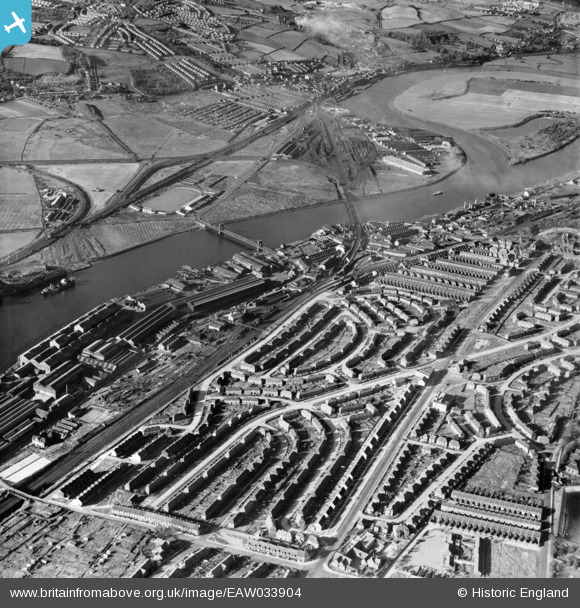
EAW033904 ENGLAND (1950). Housing estate at Scotswood looking across the River Tyne to Blaydon Haughs, Scotswood, 1950
© Copyright OpenStreetMap contributors and licensed by the OpenStreetMap Foundation. 2026. Cartography is licensed as CC BY-SA.
Nearby Images (2)
EAW033904

EAW033905

Details
| Title | [EAW033904] Housing estate at Scotswood looking across the River Tyne to Blaydon Haughs, Scotswood, 1950 |
| Reference | EAW033904 |
| Date | 19-October-1950 |
| Link | |
| Place name | SCOTSWOOD |
| Parish | |
| District | |
| Country | ENGLAND |
| Easting / Northing | 420200, 563767 |
| Longitude / Latitude | -1.6844394350543, 54.968039898423 |
| National Grid Reference | NZ202638 |
Pins

Paul |
Friday 27th of March 2026 05:12:07 PM | |
|
russellwynn@mail.com |
Sunday 21st of December 2025 08:48:57 PM | |
|
redmist |
Thursday 29th of September 2022 08:45:22 AM | |
|
redmist |
Thursday 29th of September 2022 08:44:50 AM | |
|
redmist |
Thursday 29th of September 2022 08:43:36 AM | |
|
AndyC |
Monday 6th of December 2021 01:39:37 PM | |
|
AndyC |
Monday 6th of December 2021 01:28:59 PM | |
|
AndyC |
Sunday 5th of December 2021 03:29:59 PM | |
|
AndyC |
Sunday 5th of December 2021 03:26:31 PM | |
|
AndyC |
Sunday 5th of December 2021 03:22:53 PM | |
|
AndyC |
Sunday 5th of December 2021 03:21:58 PM | |
|
AndyC |
Sunday 5th of December 2021 03:21:18 PM | |
|
AndyC |
Sunday 5th of December 2021 03:15:33 PM | |
|
AndyC |
Sunday 5th of December 2021 03:11:39 PM | |
|
AndyC |
Sunday 5th of December 2021 03:10:25 PM | |
|
AndyC |
Sunday 5th of December 2021 03:09:27 PM | |
|
AndyC |
Sunday 5th of December 2021 02:59:59 PM | |
|
AndyC |
Sunday 5th of December 2021 02:57:04 PM | |
|
AndyC |
Sunday 5th of December 2021 02:56:22 PM | |
|
AndyC |
Sunday 5th of December 2021 02:55:54 PM | |
|
AndyC |
Sunday 5th of December 2021 02:54:23 PM | |
|
AndyC |
Sunday 5th of December 2021 02:53:36 PM | |
|
AndyC |
Sunday 5th of December 2021 02:52:19 PM | |
|
AndyC |
Sunday 5th of December 2021 02:48:16 PM | |
|
AndyC |
Sunday 5th of December 2021 02:47:39 PM | |
|
AndyC |
Sunday 5th of December 2021 02:46:01 PM | |
|
AndyC |
Sunday 5th of December 2021 02:44:55 PM | |
|
AndyC |
Sunday 5th of December 2021 02:43:10 PM | |
|
AndyC |
Sunday 5th of December 2021 02:42:36 PM | |
|
AndyC |
Sunday 5th of December 2021 02:42:03 PM | |
|
AndyC |
Sunday 5th of December 2021 02:41:12 PM | |
|
AndyC |
Sunday 5th of December 2021 02:36:20 PM | |
|
AndyC |
Sunday 5th of December 2021 02:21:04 PM | |
|
AndyC |
Sunday 5th of December 2021 02:20:31 PM | |
|
AndyC |
Sunday 5th of December 2021 02:17:05 PM | |
|
AndyC |
Sunday 5th of December 2021 02:14:35 PM | |
|
AndyC |
Sunday 5th of December 2021 02:14:10 PM | |
|
Jackyboy |
Saturday 4th of July 2020 08:30:49 PM | |
|
norman |
Tuesday 5th of May 2020 12:42:49 AM | |
|
norman |
Tuesday 5th of May 2020 12:40:01 AM | |
|
redmist |
Tuesday 5th of November 2019 08:50:58 PM | |
|
dave |
Thursday 23rd of February 2017 12:19:26 PM | |
|
dave |
Thursday 23rd of February 2017 12:17:26 PM | |
|
dave |
Thursday 23rd of February 2017 12:13:47 PM | |
|
dave |
Thursday 23rd of February 2017 12:11:44 PM | |
|
Chells809 |
Thursday 16th of February 2017 09:16:38 PM |
User Comment Contributions
staring at the railway bridge at the bottom of delaval road, the allottments on near side, a small plot of land then coanwood road the other side, which was a row of terraced up and down flats,with outside toilets,most had no bathroom, small front garden a cobbled road overlooking the railway line,from newcastle central to next station was scotswood, the break along coanwood road then the newer extension of it which was council properties, im not sure if they were flats or houses but did have dorma windows in their roof, so were 3 floors, the next road up is st margarets road, first building on the gable end is davy and margaret charltons shop, along st margarets road where it joins coanwood road, then down to crosshill, st margarets road was on the shop side terraced flats,along to 2 council houses then after the lane a further row of terraced flats, across st margarets road going up delaval road after an empty plot,is more terraced flats, on the field is the old mission hut, to see this on film look at you tube newcastle upon tyne 1930, there is footage of the mission hut whitehouse road and armstrong road, fantastic to see. the next road up is whitehouse road, sadly made quite famous in the late sixties with the death of two toddlers,half way in that row of houses is blackburns shop, then the next road is delaval gardens, the shop on the corner is the coop, opposite across delaval road is delaval nursery, and woodland crescent, then an empty plot up to where the terraces resume, these were different houses,really nice looking,with a square bay window and a little front garden,the next road up is armstrong road, and the shop is mr pattersons general dealers, not sure if he owned it when this pic was taken, he did say he was there during the war,our dad and mam bought it from him in 1968,Jacky and dolly hollis,so we grew up there,across from there is forest road along into homeland looking over the bottom hodgkin park,with the fresh water spring, that comes out of the rocks and runs down a stream into a big paddling pool at the bottom of the park,the spring is from "bens well" up across benwell lane it runs down under the top park, where the old lammies and mitre used to be,its where the name benwell comes from because thats where ben had his well, back to the shop, across armstrong road is delaval infants school, and behind that is delaval junior school,back onto armstrong road is next door to our shop was that i know natrass's shop, my dad bought that shop aswell, thats on the corner of cranbrook road, along armstrong road is wayside, then stoneyhurst that goes along to haig crescent, which runs down to ranmere road, the bobby shaftoe has not been built yet,on armstrong road is the rialto picture house which was later a bingo,when we were kids some americans came and did a yoyo show outside the rialto,across the road was lindseys fish shop a couple of other shops then a big coop, which was later called the pink palace, then whitehouse road, with emerson lowes and a few other shops, across the road the post office isnt built yet, but crawfords, hazels hairdressers, and johnny and rose oswells is there,straight across from the top of whitehouse road is woodstock road that goes through to denton road,along armstrong road pat the whitehouse woodstock junction, is after the empty plot dr russels surgery, then council houses then a row of flats along to mr tomlinsons shop opposite scotswood baths, the library, and st margarets church, with denton road schools opposite, what a suberb picture i love it, |
jacqueline hollis |
Sunday 3rd of May 2015 08:19:59 PM |
jacqueline hollis, this is a treat, fantastic, from bottom left the railway bridge, first road is coanwood road, next up is st margarets road, daveys shop on the corner, continuing up delaval road that little hut behind the houses was the mission hut, sunday school, and the allotments the other side of delaval road, half way through that terrace is blackburns shop, then on the top corner was a coop,junction of delaval road and delaval gardens, opposite is the nursery on woodland crescent,further up is the junction of armstrong road and delaval, the corner shop in those days belonged to a mr and mrs patterson, they sold it to my dad and mam jacky and dolly hollis in summer 1967, across armstrong road delaval rd infants, up again delaval juniors,up delaval road to axwell view and the water works, with the resevoir,theres absolutley loads more information in this one picture, i will continue another time, wonderful memories jacqueline |
jacqueline hollis |
Friday 10th of April 2015 10:04:10 AM |