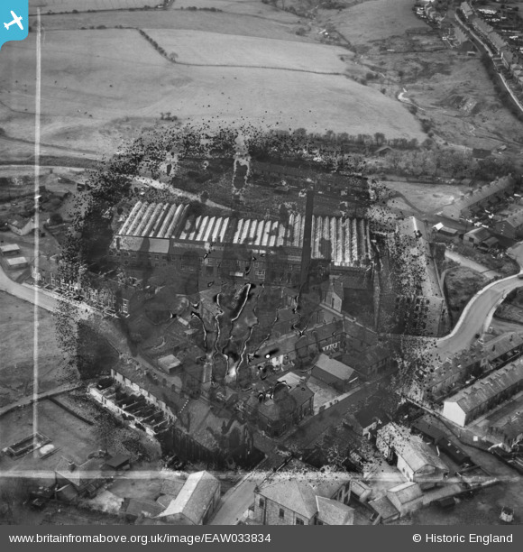
EAW033834 ENGLAND (1950). Lower Darwen Mill, Lower Darwen, 1950. This image has been produced from a damaged negative.
© Copyright OpenStreetMap contributors and licensed by the OpenStreetMap Foundation. 2026. Cartography is licensed as CC BY-SA.
Nearby Images (10)
Details
| Title | [EAW033834] Lower Darwen Mill, Lower Darwen, 1950. This image has been produced from a damaged negative. |
| Reference | EAW033834 |
| Date | 16-October-1950 |
| Link | |
| Place name | LOWER DARWEN |
| Parish | |
| District | |
| Country | ENGLAND |
| Easting / Northing | 368771, 425036 |
| Longitude / Latitude | -2.4733018829842, 53.720573315414 |
| National Grid Reference | SD688250 |
Pins

Matt Aldred edob.mattaldred.com |
Friday 8th of March 2024 06:02:50 PM | |

Matt Aldred edob.mattaldred.com |
Friday 8th of March 2024 06:00:21 PM | |

Matt Aldred edob.mattaldred.com |
Friday 8th of March 2024 05:59:36 PM | |

Matt Aldred edob.mattaldred.com |
Friday 8th of March 2024 05:59:23 PM | |

Matt Aldred edob.mattaldred.com |
Tuesday 1st of February 2022 08:50:08 PM |


![[EAW033834] Lower Darwen Mill, Lower Darwen, 1950. This image has been produced from a damaged negative.](http://britainfromabove.org.uk/sites/all/libraries/aerofilms-images/public/100x100/EAW/033/EAW033834.jpg)
![[EAW033833] Lower Darwen Mill, Lower Darwen, 1950. This image has been produced from a damaged negative.](http://britainfromabove.org.uk/sites/all/libraries/aerofilms-images/public/100x100/EAW/033/EAW033833.jpg)
![[EAW033840] Lower Darwen Mill, Lower Darwen, 1950. This image was marked by Aerofilms Ltd for photo editing.](http://britainfromabove.org.uk/sites/all/libraries/aerofilms-images/public/100x100/EAW/033/EAW033840.jpg)
![[EAW033837] Lower Darwen Mill, Lower Darwen, 1950. This image was marked by Aerofilms Ltd for photo editing.](http://britainfromabove.org.uk/sites/all/libraries/aerofilms-images/public/100x100/EAW/033/EAW033837.jpg)
![[EAW033838] Lower Darwen Mill, Lower Darwen, 1950. This image was marked by Aerofilms Ltd for photo editing.](http://britainfromabove.org.uk/sites/all/libraries/aerofilms-images/public/100x100/EAW/033/EAW033838.jpg)
![[EAW033836] Lower Darwen Mill, Lower Darwen, 1950. This image was marked by Aerofilms Ltd for photo editing.](http://britainfromabove.org.uk/sites/all/libraries/aerofilms-images/public/100x100/EAW/033/EAW033836.jpg)
![[EAW033832] Lower Darwen Mill, Lower Darwen, 1950. This image was marked by Aerofilms Ltd for photo editing.](http://britainfromabove.org.uk/sites/all/libraries/aerofilms-images/public/100x100/EAW/033/EAW033832.jpg)
![[EAW033839] Lower Darwen Mill, Lower Darwen, 1950. This image was marked by Aerofilms Ltd for photo editing.](http://britainfromabove.org.uk/sites/all/libraries/aerofilms-images/public/100x100/EAW/033/EAW033839.jpg)
![[EAW033831] Lower Darwen Mill, Lower Darwen, 1950. This image was marked by Aerofilms Ltd for photo editing.](http://britainfromabove.org.uk/sites/all/libraries/aerofilms-images/public/100x100/EAW/033/EAW033831.jpg)
![[EAW033835] Lower Darwen Mill, Lower Darwen, 1950. This image was marked by Aerofilms Ltd for photo editing.](http://britainfromabove.org.uk/sites/all/libraries/aerofilms-images/public/100x100/EAW/033/EAW033835.jpg)