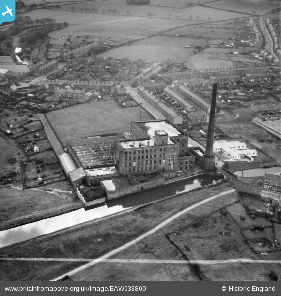
EAW033800 ENGLAND (1950). The Albion Mill, Ewood, 1950. This image was marked by Aerofilms Ltd for photo editing.
© Copyright OpenStreetMap contributors and licensed by the OpenStreetMap Foundation. 2026. Cartography is licensed as CC BY-SA.
Nearby Images (10)
Details
| Title | [EAW033800] The Albion Mill, Ewood, 1950. This image was marked by Aerofilms Ltd for photo editing. |
| Reference | EAW033800 |
| Date | 16-October-1950 |
| Link | |
| Place name | EWOOD |
| Parish | |
| District | |
| Country | ENGLAND |
| Easting / Northing | 367399, 426239 |
| Longitude / Latitude | -2.494221657235, 53.731302893656 |
| National Grid Reference | SD674262 |
Pins
Be the first to add a comment to this image!


![[EAW033800] The Albion Mill, Ewood, 1950. This image was marked by Aerofilms Ltd for photo editing.](http://britainfromabove.org.uk/sites/all/libraries/aerofilms-images/public/100x100/EAW/033/EAW033800.jpg)
![[EAW033795] The Albion Mill and Leeds and Liverpool Canal, Ewood, 1950. This image was marked by Aerofilms Ltd for photo editing.](http://britainfromabove.org.uk/sites/all/libraries/aerofilms-images/public/100x100/EAW/033/EAW033795.jpg)
![[EAW033793] The Albion Mill and Leeds and Liverpool Canal, Ewood, 1950. This image was marked by Aerofilms Ltd for photo editing.](http://britainfromabove.org.uk/sites/all/libraries/aerofilms-images/public/100x100/EAW/033/EAW033793.jpg)
![[EAW033797] The Albion Mill and Leeds and Liverpool Canal, Ewood, 1950. This image was marked by Aerofilms Ltd for photo editing.](http://britainfromabove.org.uk/sites/all/libraries/aerofilms-images/public/100x100/EAW/033/EAW033797.jpg)
![[EAW033794] The Albion Mill, Ewood, 1950. This image was marked by Aerofilms Ltd for photo editing.](http://britainfromabove.org.uk/sites/all/libraries/aerofilms-images/public/100x100/EAW/033/EAW033794.jpg)
![[EAW033798] The Albion Mill, Ewood, 1950. This image was marked by Aerofilms Ltd for photo editing.](http://britainfromabove.org.uk/sites/all/libraries/aerofilms-images/public/100x100/EAW/033/EAW033798.jpg)
![[EAW033802] The Albion Mill, Ewood, 1950. This image was marked by Aerofilms Ltd for photo editing.](http://britainfromabove.org.uk/sites/all/libraries/aerofilms-images/public/100x100/EAW/033/EAW033802.jpg)
![[EAW033799] The Albion Mill, Ewood, 1950. This image was marked by Aerofilms Ltd for photo editing.](http://britainfromabove.org.uk/sites/all/libraries/aerofilms-images/public/100x100/EAW/033/EAW033799.jpg)
![[EAW033796] The Albion Mill, Ewood, 1950. This image was marked by Aerofilms Ltd for photo editing.](http://britainfromabove.org.uk/sites/all/libraries/aerofilms-images/public/100x100/EAW/033/EAW033796.jpg)
![[EAW033801] The Albion Mill, Ewood, 1950. This image was marked by Aerofilms Ltd for photo editing.](http://britainfromabove.org.uk/sites/all/libraries/aerofilms-images/public/100x100/EAW/033/EAW033801.jpg)