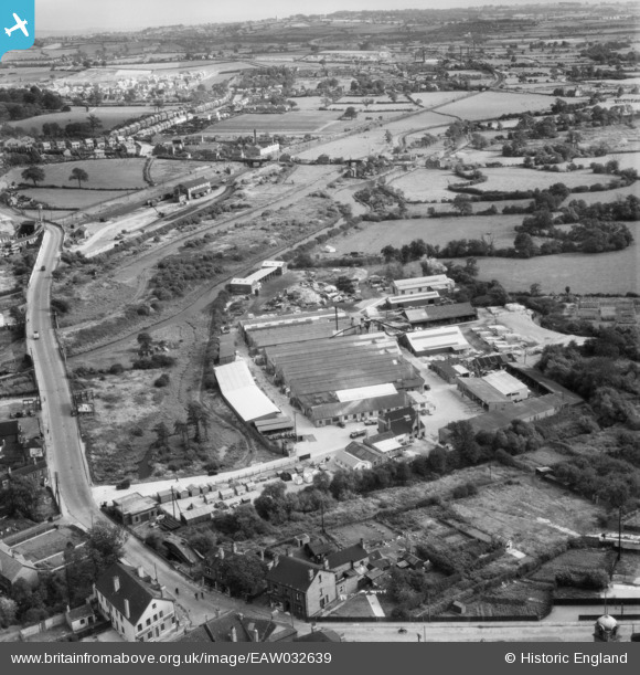
EAW032639 ENGLAND (1950). Vic Hallam Ltd Works and environs, Langley Mill, from the north-west, 1950
© Copyright OpenStreetMap contributors and licensed by the OpenStreetMap Foundation. 2025. Cartography is licensed as CC BY-SA.
Nearby Images (17)
Details
| Title | [EAW032639] Vic Hallam Ltd Works and environs, Langley Mill, from the north-west, 1950 |
| Reference | EAW032639 |
| Date | 18-September-1950 |
| Link | |
| Place name | LANGLEY MILL |
| Parish | ALDERCAR AND LANGLEY MILL |
| District | |
| Country | ENGLAND |
| Easting / Northing | 445243, 347102 |
| Longitude / Latitude | -1.3254766141626, 53.018995525996 |
| National Grid Reference | SK452471 |
Pins

Matt Aldred edob.mattaldred.com |
Monday 11th of March 2024 03:50:10 PM | |

retrobitz |
Sunday 7th of June 2020 04:16:21 PM | |

Class31 |
Tuesday 18th of November 2014 11:56:23 AM | |

Class31 |
Tuesday 18th of November 2014 11:53:17 AM | |

Class31 |
Tuesday 18th of November 2014 11:52:12 AM | |

Class31 |
Tuesday 18th of November 2014 11:51:14 AM | |

Class31 |
Tuesday 18th of November 2014 11:50:16 AM | |

Class31 |
Tuesday 18th of November 2014 11:40:43 AM | |

Class31 |
Tuesday 18th of November 2014 11:40:06 AM | |

Class31 |
Tuesday 18th of November 2014 11:39:21 AM | |

Class31 |
Wednesday 13th of August 2014 09:12:22 AM |
User Comment Contributions
Erewash Canal at Langley Mill, 12/08/2014 |

Class31 |
Tuesday 18th of November 2014 11:53:46 AM |


![[EAW032639] Vic Hallam Ltd Works and environs, Langley Mill, from the north-west, 1950](http://britainfromabove.org.uk/sites/all/libraries/aerofilms-images/public/100x100/EAW/032/EAW032639.jpg)
![[EAW032636] Vic Hallam Ltd Works and environs, Langley Mill, from the north-west, 1950. This image was marked by Aerofilms Ltd for photo editing.](http://britainfromabove.org.uk/sites/all/libraries/aerofilms-images/public/100x100/EAW/032/EAW032636.jpg)
![[EAW032637] Vic Hallam Ltd Works and environs, Langley Mill, 1950. This image was marked by Aerofilms Ltd for photo editing.](http://britainfromabove.org.uk/sites/all/libraries/aerofilms-images/public/100x100/EAW/032/EAW032637.jpg)
![[EAW032634] Vic Hallam Ltd Works and environs, Langley Mill, 1950. This image was marked by Aerofilms Ltd for photo editing.](http://britainfromabove.org.uk/sites/all/libraries/aerofilms-images/public/100x100/EAW/032/EAW032634.jpg)
![[EAW032632] Vic Hallam Ltd Works and environs, Langley Mill, 1950](http://britainfromabove.org.uk/sites/all/libraries/aerofilms-images/public/100x100/EAW/032/EAW032632.jpg)
![[EAW032640] Vic Hallam Ltd Works and environs, Langley Mill, 1950](http://britainfromabove.org.uk/sites/all/libraries/aerofilms-images/public/100x100/EAW/032/EAW032640.jpg)
![[EAW032631] Vic Hallam Ltd Works, Langley Mill, 1950. This image was marked by Aerofilms Ltd for photo editing.](http://britainfromabove.org.uk/sites/all/libraries/aerofilms-images/public/100x100/EAW/032/EAW032631.jpg)
![[EAW032630] Vic Hallam Ltd Works, Langley Mill, 1950. This image was marked by Aerofilms Ltd for photo editing.](http://britainfromabove.org.uk/sites/all/libraries/aerofilms-images/public/100x100/EAW/032/EAW032630.jpg)
![[EAW032635] Vic Hallam Ltd Works, Langley Mill, 1950. This image was marked by Aerofilms Ltd for photo editing.](http://britainfromabove.org.uk/sites/all/libraries/aerofilms-images/public/100x100/EAW/032/EAW032635.jpg)
![[EAW032633] Vic Hallam Ltd Works and environs, Langley Mill, from the south-east, 1950](http://britainfromabove.org.uk/sites/all/libraries/aerofilms-images/public/100x100/EAW/032/EAW032633.jpg)
![[EAW032638] Vic Hallam Ltd Works and environs, Langley Mill, 1950](http://britainfromabove.org.uk/sites/all/libraries/aerofilms-images/public/100x100/EAW/032/EAW032638.jpg)
![[EPR000161] The Lovatts Potteries Ltd Langley Art Pottery and environs, Langley Mill, 1934. This image was marked by Aero Pictorial Ltd for photo editing.](http://britainfromabove.org.uk/sites/all/libraries/aerofilms-images/public/100x100/EPR/000/EPR000161.jpg)
![[EPR000163] The Lovatts Potteries Ltd Langley Art Pottery and environs, Langley Mill, 1934](http://britainfromabove.org.uk/sites/all/libraries/aerofilms-images/public/100x100/EPR/000/EPR000163.jpg)
![[EPR000144] G.R. Turner Ltd Wagon and Engineering Works, Langley Mill, 1934](http://britainfromabove.org.uk/sites/all/libraries/aerofilms-images/public/100x100/EPR/000/EPR000144.jpg)
![[EPR000162] The Lovatts Potteries Ltd Langley Art Pottery and environs, Langley Mill, 1934. This image was marked by Aero Pictorial Ltd for photo editing.](http://britainfromabove.org.uk/sites/all/libraries/aerofilms-images/public/100x100/EPR/000/EPR000162.jpg)
![[EPR000145] G.R. Turner Ltd Wagon and Engineering Works, Langley Mill, 1934. This image was marked by Aero Pictorial Ltd for photo editing.](http://britainfromabove.org.uk/sites/all/libraries/aerofilms-images/public/100x100/EPR/000/EPR000145.jpg)
![[EPR000146] G.R. Turner Ltd Wagon and Engineering Works, Langley Mill, 1934](http://britainfromabove.org.uk/sites/all/libraries/aerofilms-images/public/100x100/EPR/000/EPR000146.jpg)