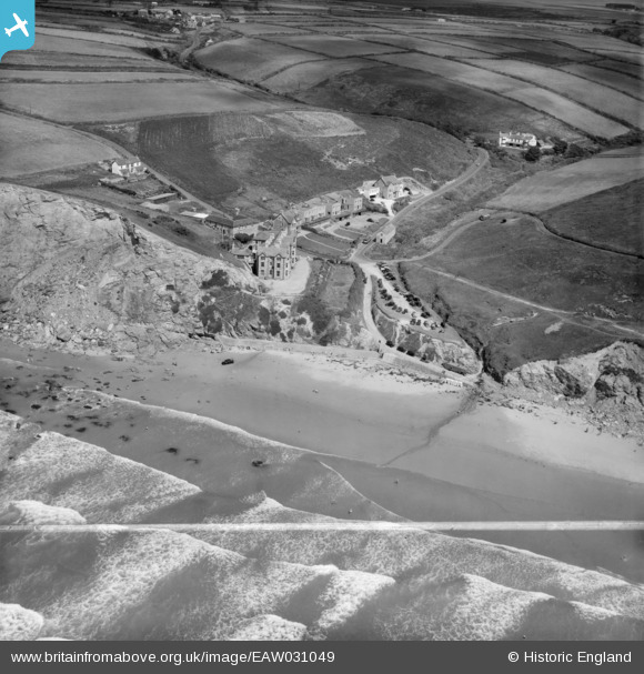
EAW031049 ENGLAND (1950). Watergate Beach and Tregurrian Hill, Newquay, 1950. This image was marked by Aerofilms Ltd for photo editing.
© Copyright OpenStreetMap contributors and licensed by the OpenStreetMap Foundation. 2025. Cartography is licensed as CC BY-SA.
Nearby Images (6)
Details
| Title | [EAW031049] Watergate Beach and Tregurrian Hill, Newquay, 1950. This image was marked by Aerofilms Ltd for photo editing. |
| Reference | EAW031049 |
| Date | 11-July-1950 |
| Link | |
| Place name | NEWQUAY |
| Parish | NEWQUAY |
| District | |
| Country | ENGLAND |
| Easting / Northing | 184129, 64947 |
| Longitude / Latitude | -5.0407869430331, 50.443995746088 |
| National Grid Reference | SW841649 |
Pins

redmist |
Wednesday 21st of June 2023 09:14:20 PM |


![[EAW031049] Watergate Beach and Tregurrian Hill, Newquay, 1950. This image was marked by Aerofilms Ltd for photo editing.](http://britainfromabove.org.uk/sites/all/libraries/aerofilms-images/public/100x100/EAW/031/EAW031049.jpg)
![[EAW031052] Watergate Bay Hotel and Cleavelands Hotel on Tregurrian Hill, Newquay, 1950. This image was marked by Aerofilms Ltd for photo editing.](http://britainfromabove.org.uk/sites/all/libraries/aerofilms-images/public/100x100/EAW/031/EAW031052.jpg)
![[EAW031053] The Watergate Bay Hotel and Cleavelands Hotel on Tregurrian Hill, Newquay, 1950. This image was marked by Aerofilms Ltd for photo editing.](http://britainfromabove.org.uk/sites/all/libraries/aerofilms-images/public/100x100/EAW/031/EAW031053.jpg)
![[EAW031051] Watergate Beach and Tregurrian Hill, Newquay, from the west, 1950. This image was marked by Aerofilms Ltd for photo editing.](http://britainfromabove.org.uk/sites/all/libraries/aerofilms-images/public/100x100/EAW/031/EAW031051.jpg)
![[EAW031048] Cleavelands Hotel on Tregurrian Hill, Newquay, 1950. This image was marked by Aerofilms Ltd for photo editing.](http://britainfromabove.org.uk/sites/all/libraries/aerofilms-images/public/100x100/EAW/031/EAW031048.jpg)
![[EAW031050] Cleavelands Hotel on Tregurrian Hill, Newquay, 1950. This image was marked by Aerofilms Ltd for photo editing.](http://britainfromabove.org.uk/sites/all/libraries/aerofilms-images/public/100x100/EAW/031/EAW031050.jpg)