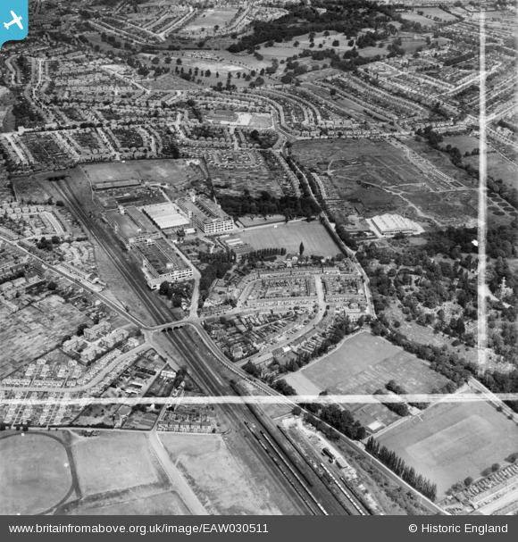
EAW030511 ENGLAND (1950). Standard Telephones and Cables Works and the surrounding area, Brunswick Park, 1950. This image was marked by Aerofilms Ltd for photo editing.
© Copyright OpenStreetMap contributors and licensed by the OpenStreetMap Foundation. 2026. Cartography is licensed as CC BY-SA.
Nearby Images (36)
Details
| Title | [EAW030511] Standard Telephones and Cables Works and the surrounding area, Brunswick Park, 1950. This image was marked by Aerofilms Ltd for photo editing. |
| Reference | EAW030511 |
| Date | 26-June-1950 |
| Link | |
| Place name | BRUNSWICK PARK |
| Parish | |
| District | |
| Country | ENGLAND |
| Easting / Northing | 528174, 193390 |
| Longitude / Latitude | -0.14816108834791, 51.624242750876 |
| National Grid Reference | TQ282934 |
Pins
Be the first to add a comment to this image!


![[EAW030511] Standard Telephones and Cables Works and the surrounding area, Brunswick Park, 1950. This image was marked by Aerofilms Ltd for photo editing.](http://britainfromabove.org.uk/sites/all/libraries/aerofilms-images/public/100x100/EAW/030/EAW030511.jpg)
![[EAW030510] Standard Telephones and Cables Works and the surrounding area, Brunswick Park, 1950](http://britainfromabove.org.uk/sites/all/libraries/aerofilms-images/public/100x100/EAW/030/EAW030510.jpg)
![[EAW030515] Standard Telephones and Cables Works and the surrounding area, Brunswick Park, 1950. This image was marked by Aerofilms Ltd for photo editing.](http://britainfromabove.org.uk/sites/all/libraries/aerofilms-images/public/100x100/EAW/030/EAW030515.jpg)
![[EAW006130] Standard Telephones & Cables New Southgate Works and environs, Brunswick Park, from the south-east, 1947. This image was marked by Aerofilms Ltd for photo editing.](http://britainfromabove.org.uk/sites/all/libraries/aerofilms-images/public/100x100/EAW/006/EAW006130.jpg)
![[EAW031726] Standard Telephones and Cables Ltd New Southgate Works and environs, Brunswick Park, 1950. This image was marked by Aerofilms Ltd for photo editing.](http://britainfromabove.org.uk/sites/all/libraries/aerofilms-images/public/100x100/EAW/031/EAW031726.jpg)
![[EAW030509] Standard Telephones and Cables Works, Brunswick Park, 1950. This image was marked by Aerofilms Ltd for photo editing.](http://britainfromabove.org.uk/sites/all/libraries/aerofilms-images/public/100x100/EAW/030/EAW030509.jpg)
![[EAW004112] Standard Telephones and Cables Works, New Southgate, 1947. This image was marked by Aerofilms Ltd for photo editing.](http://britainfromabove.org.uk/sites/all/libraries/aerofilms-images/public/100x100/EAW/004/EAW004112.jpg)
![[EAW006131] Standard Telephones & Cables New Southgate Works and environs, Brunswick Park, from the south, 1947](http://britainfromabove.org.uk/sites/all/libraries/aerofilms-images/public/100x100/EAW/006/EAW006131.jpg)
![[EPW046479A] Standard Telephones and Cables New Southgate Works, Brunswick Park, 1935](http://britainfromabove.org.uk/sites/all/libraries/aerofilms-images/public/100x100/EPW/046/EPW046479A.jpg)
![[EAW030512] Standard Telephones and Cables Works and the surrounding area, Brunswick Park, 1950. This image was marked by Aerofilms Ltd for photo editing.](http://britainfromabove.org.uk/sites/all/libraries/aerofilms-images/public/100x100/EAW/030/EAW030512.jpg)
![[EPW046474] Standard Telephones and Cables New Southgate Works and environs, Brunswick Park, 1935](http://britainfromabove.org.uk/sites/all/libraries/aerofilms-images/public/100x100/EPW/046/EPW046474.jpg)
![[EAW030507] Standard Telephones and Cables Works, Brunswick Park, 1950. This image was marked by Aerofilms Ltd for photo editing.](http://britainfromabove.org.uk/sites/all/libraries/aerofilms-images/public/100x100/EAW/030/EAW030507.jpg)
![[EPW046473] Standard Telephones and Cables New Southgate Works, Brunswick Park, 1935](http://britainfromabove.org.uk/sites/all/libraries/aerofilms-images/public/100x100/EPW/046/EPW046473.jpg)
![[EPW046471] Standard Telephones and Cables New Southgate Works, Brunswick Park, 1935](http://britainfromabove.org.uk/sites/all/libraries/aerofilms-images/public/100x100/EPW/046/EPW046471.jpg)
![[EAW031728] Standard Telephones and Cables Ltd New Southgate Works and environs, Brunswick Park, 1950. This image was marked by Aerofilms Ltd for photo editing.](http://britainfromabove.org.uk/sites/all/libraries/aerofilms-images/public/100x100/EAW/031/EAW031728.jpg)
![[EPW046478] Standard Telephones and Cables New Southgate Works and environs, Brunswick Park, 1935](http://britainfromabove.org.uk/sites/all/libraries/aerofilms-images/public/100x100/EPW/046/EPW046478.jpg)
![[EPW046472] Standard Telephones and Cables New Southgate Works, Brunswick Park, 1935](http://britainfromabove.org.uk/sites/all/libraries/aerofilms-images/public/100x100/EPW/046/EPW046472.jpg)
![[EPW046475] Standard Telephones and Cables New Southgate Works, Brunswick Park, 1935](http://britainfromabove.org.uk/sites/all/libraries/aerofilms-images/public/100x100/EPW/046/EPW046475.jpg)
![[EPW046477] Standard Telephones and Cables New Southgate Works and environs, Brunswick Park, 1935](http://britainfromabove.org.uk/sites/all/libraries/aerofilms-images/public/100x100/EPW/046/EPW046477.jpg)
![[EPW046476] Standard Telephones and Cables New Southgate Works and environs, Brunswick Park, 1935](http://britainfromabove.org.uk/sites/all/libraries/aerofilms-images/public/100x100/EPW/046/EPW046476.jpg)
![[EAW030504] Standard Telephones and Cables Works, Brunswick Park, 1950. This image was marked by Aerofilms Ltd for photo editing.](http://britainfromabove.org.uk/sites/all/libraries/aerofilms-images/public/100x100/EAW/030/EAW030504.jpg)
![[EAW031724] Standard Telephones and Cables Ltd New Southgate Works and environs, Brunswick Park, 1950. This image was marked by Aerofilms Ltd for photo editing.](http://britainfromabove.org.uk/sites/all/libraries/aerofilms-images/public/100x100/EAW/031/EAW031724.jpg)
![[EAW004115] Standard Telephones and Cables Works, New Southgate, from the south, 1947](http://britainfromabove.org.uk/sites/all/libraries/aerofilms-images/public/100x100/EAW/004/EAW004115.jpg)
![[EAW006132] Standard Telephones & Cables New Southgate Works and environs, Brunswick Park, from the south, 1947](http://britainfromabove.org.uk/sites/all/libraries/aerofilms-images/public/100x100/EAW/006/EAW006132.jpg)
![[EAW031725] Standard Telephones and Cables Ltd New Southgate Works and environs, Brunswick Park, 1950. This image was marked by Aerofilms Ltd for photo editing.](http://britainfromabove.org.uk/sites/all/libraries/aerofilms-images/public/100x100/EAW/031/EAW031725.jpg)
![[EAW004113] Standard Telephones and Cables Works, New Southgate, 1947. This image was marked by Aerofilms Ltd for photo editing.](http://britainfromabove.org.uk/sites/all/libraries/aerofilms-images/public/100x100/EAW/004/EAW004113.jpg)
![[EAW004114] Standard Telephones and Cables Works, New Southgate, from the south, 1947](http://britainfromabove.org.uk/sites/all/libraries/aerofilms-images/public/100x100/EAW/004/EAW004114.jpg)
![[EAW030508] Standard Telephones and Cables Works, Brunswick Park, 1950. This image was marked by Aerofilms Ltd for photo editing.](http://britainfromabove.org.uk/sites/all/libraries/aerofilms-images/public/100x100/EAW/030/EAW030508.jpg)
![[EAW030514] Standard Telephones and Cables Works and the surrounding area, Brunswick Park, 1950. This image was marked by Aerofilms Ltd for photo editing.](http://britainfromabove.org.uk/sites/all/libraries/aerofilms-images/public/100x100/EAW/030/EAW030514.jpg)
![[EAW030503] Standard Telephones and Cables Works, Brunswick Park, from the south, 1950. This image was marked by Aerofilms Ltd for photo editing.](http://britainfromabove.org.uk/sites/all/libraries/aerofilms-images/public/100x100/EAW/030/EAW030503.jpg)
![[EPW046479] Standard Telephones and Cables New Southgate Works and environs, Brunswick Park, 1935](http://britainfromabove.org.uk/sites/all/libraries/aerofilms-images/public/100x100/EPW/046/EPW046479.jpg)
![[EAW030513] Standard Telephones and Cables Works and the surrounding area, Brunswick Park, 1950. This image was marked by Aerofilms Ltd for photo editing.](http://britainfromabove.org.uk/sites/all/libraries/aerofilms-images/public/100x100/EAW/030/EAW030513.jpg)
![[EAW031730] Standard Telephones and Cables Ltd New Southgate Works and environs, Brunswick Park, 1950. This image was marked by Aerofilms Ltd for photo editing.](http://britainfromabove.org.uk/sites/all/libraries/aerofilms-images/public/100x100/EAW/031/EAW031730.jpg)
![[EAW030505] Standard Telephones and Cables Works, Brunswick Park, from the south, 1950. This image was marked by Aerofilms Ltd for photo editing.](http://britainfromabove.org.uk/sites/all/libraries/aerofilms-images/public/100x100/EAW/030/EAW030505.jpg)
![[EAW031727] Standard Telephones and Cables Ltd New Southgate Works and environs, Brunswick Park, 1950. This image was marked by Aerofilms Ltd for photo editing.](http://britainfromabove.org.uk/sites/all/libraries/aerofilms-images/public/100x100/EAW/031/EAW031727.jpg)
![[EAW030506] Standard Telephones and Cables Works, Brunswick Park, 1950. This image was marked by Aerofilms Ltd for photo editing.](http://britainfromabove.org.uk/sites/all/libraries/aerofilms-images/public/100x100/EAW/030/EAW030506.jpg)