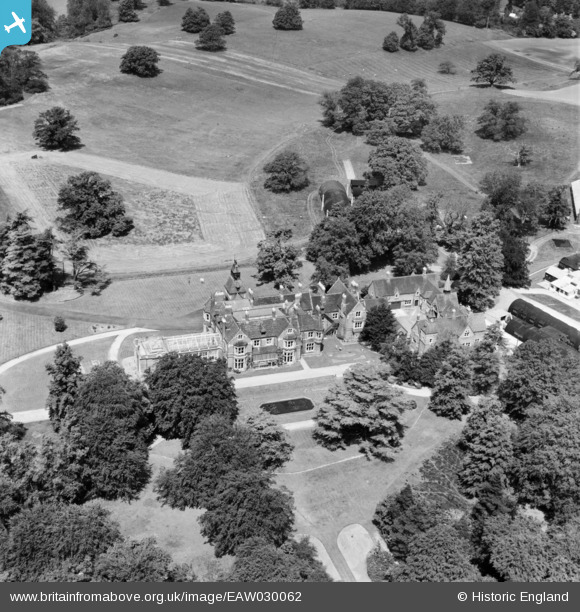
EAW030062 ENGLAND (1950). Silwood Park, Sunninghill, 1950
© Copyright OpenStreetMap contributors and licensed by the OpenStreetMap Foundation. 2024. Cartography is licensed as CC BY-SA.
Nearby Images (9)
Details
| Title | [EAW030062] Silwood Park, Sunninghill, 1950 |
| Reference | EAW030062 |
| Date | 1-June-1950 |
| Link | |
| Place name | SUNNINGHILL |
| Parish | SUNNINGHILL AND ASCOT |
| District | |
| Country | ENGLAND |
| Easting / Northing | 494619, 168624 |
| Longitude / Latitude | -0.63943529177264, 51.408242719266 |
| National Grid Reference | SU946686 |
Pins
Be the first to add a comment to this image!


![[EAW030062] Silwood Park, Sunninghill, 1950](http://britainfromabove.org.uk/sites/all/libraries/aerofilms-images/public/100x100/EAW/030/EAW030062.jpg)
![[EAW030060] Silwood Park, Sunninghill, 1950. This image was marked by Aerofilms Ltd for photo editing.](http://britainfromabove.org.uk/sites/all/libraries/aerofilms-images/public/100x100/EAW/030/EAW030060.jpg)
![[EAW030061] Silwood Park, Sunninghill, 1950](http://britainfromabove.org.uk/sites/all/libraries/aerofilms-images/public/100x100/EAW/030/EAW030061.jpg)
![[EAW030053] The Imperial College Field Station at Silwood Park, Sunninghill, 1950. This image was marked by Aerofilms Ltd for photo editing.](http://britainfromabove.org.uk/sites/all/libraries/aerofilms-images/public/100x100/EAW/030/EAW030053.jpg)
![[EAW030059] The Imperial College Field Station at Silwood Park, Sunninghill, 1950. This image was marked by Aerofilms Ltd for photo editing.](http://britainfromabove.org.uk/sites/all/libraries/aerofilms-images/public/100x100/EAW/030/EAW030059.jpg)
![[EAW030052] The Imperial College Field Station at Silwood Park, Sunninghill, 1950. This image was marked by Aerofilms Ltd for photo editing.](http://britainfromabove.org.uk/sites/all/libraries/aerofilms-images/public/100x100/EAW/030/EAW030052.jpg)
![[EAW030057] The Imperial College Field Station at Silwood Park, Sunninghill, 1950](http://britainfromabove.org.uk/sites/all/libraries/aerofilms-images/public/100x100/EAW/030/EAW030057.jpg)
![[EAW030055] The Imperial College Field Station at Silwood Park, Sunninghill, 1950. This image was marked by Aerofilms Ltd for photo editing.](http://britainfromabove.org.uk/sites/all/libraries/aerofilms-images/public/100x100/EAW/030/EAW030055.jpg)
![[EAW030054] The Imperial College Field Station at Silwood Park, Sunninghill, 1950. This image was marked by Aerofilms Ltd for photo editing.](http://britainfromabove.org.uk/sites/all/libraries/aerofilms-images/public/100x100/EAW/030/EAW030054.jpg)