
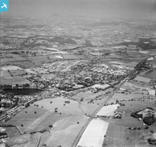
EAW030046 ENGLAND (1950). The town, Alsager, from the south-west, 1950

© Copyright OpenStreetMap contributors and licensed by the OpenStreetMap Foundation. 2026. Cartography is licensed as CC BY-SA.
Details
| Title | [EAW030046] The town, Alsager, from the south-west, 1950 |
| Reference | EAW030046 |
| Date | 1-June-1950 |
| Link | |
| Place name | ALSAGER |
| Parish | ALSAGER |
| District | |
| Country | ENGLAND |
| Easting / Northing | 379412, 355217 |
| Longitude / Latitude | -2.3074725806551, 53.093465948874 |
| National Grid Reference | SJ794552 |
Pins

geoff |
Tuesday 27th of January 2015 08:33:32 PM | |
|
Sidecar Steve |
Wednesday 12th of November 2014 11:26:04 PM | |

bescotbeast |
Friday 19th of September 2014 12:46:58 AM | |
|
bescotbeast |
Friday 19th of September 2014 12:45:00 AM | |
|
bescotbeast |
Friday 19th of September 2014 12:40:54 AM | |
|
bescotbeast |
Friday 19th of September 2014 12:38:23 AM | |
|
bescotbeast |
Friday 19th of September 2014 12:35:47 AM | |
|
bescotbeast |
Friday 19th of September 2014 12:35:05 AM |
User Comment Contributions
Alsager Station signal box McK Holland Type 1, Alsager East Junction signal box NSR Type 1 and Lawton signal box LNW Type 5. |
bescotbeast |
Friday 19th of September 2014 12:42:37 AM |