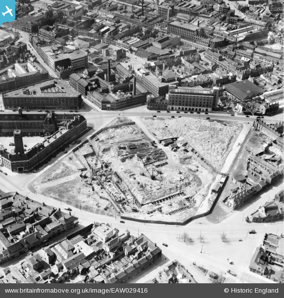
EAW029416 ENGLAND (1950). A construction site next to the Central Fire Station between Potter Street and Fisher Street, Birmingham, 1950
© Copyright OpenStreetMap contributors and licensed by the OpenStreetMap Foundation. 2026. Cartography is licensed as CC BY-SA.
Details
| Title | [EAW029416] A construction site next to the Central Fire Station between Potter Street and Fisher Street, Birmingham, 1950 |
| Reference | EAW029416 |
| Date | 10-May-1950 |
| Link | |
| Place name | BIRMINGHAM |
| Parish | |
| District | |
| Country | ENGLAND |
| Easting / Northing | 407507, 287672 |
| Longitude / Latitude | -1.8894358708175, 52.486545652863 |
| National Grid Reference | SP075877 |
Pins

Matt Aldred edob.mattaldred.com |
Sunday 30th of January 2022 05:12:22 PM | |

Andy |
Tuesday 1st of May 2018 12:31:31 PM | |

Griffin |
Wednesday 21st of October 2015 10:11:46 PM | |

Griffin |
Wednesday 21st of October 2015 10:10:06 PM | |

Slatertim |
Wednesday 21st of May 2014 01:33:47 PM | |

Slatertim |
Wednesday 21st of May 2014 01:33:15 PM |


![[EAW029416] A construction site next to the Central Fire Station between Potter Street and Fisher Street, Birmingham, 1950](http://britainfromabove.org.uk/sites/all/libraries/aerofilms-images/public/100x100/EAW/029/EAW029416.jpg)
![[EPW053755] The City Tube Mills and Central Fire Station, Birmingham, 1937](http://britainfromabove.org.uk/sites/all/libraries/aerofilms-images/public/100x100/EPW/053/EPW053755.jpg)
![[EPW053753] The Central Fire Station, Aston Street and environs, Birmingham, 1937](http://britainfromabove.org.uk/sites/all/libraries/aerofilms-images/public/100x100/EPW/053/EPW053753.jpg)
![[EPW053754] The Central Fire Station, City Tube Mills on Moland Street and environs, Birmingham, 1937](http://britainfromabove.org.uk/sites/all/libraries/aerofilms-images/public/100x100/EPW/053/EPW053754.jpg)