
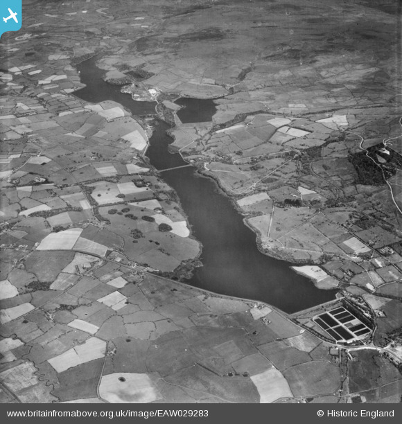
EAW029283 ENGLAND (1950). Upper and Lower Rivington Reservoirs, Yarrow Reservoir and Anglezarke Reservoir, Rivington, 1950
© Copyright OpenStreetMap contributors and licensed by the OpenStreetMap Foundation. 2026. Cartography is licensed as CC BY-SA.
Nearby Images (3)
EAW029283

EAW029282

EAW029284

Details
| Title | [EAW029283] Upper and Lower Rivington Reservoirs, Yarrow Reservoir and Anglezarke Reservoir, Rivington, 1950 |
| Reference | EAW029283 |
| Date | 11-May-1950 |
| Link | |
| Place name | RIVINGTON |
| Parish | RIVINGTON |
| District | |
| Country | ENGLAND |
| Easting / Northing | 362483, 413690 |
| Longitude / Latitude | -2.567225692898, 53.61817249675 |
| National Grid Reference | SD625137 |
Pins

totoro |
Monday 3rd of March 2014 06:22:28 PM | |
|
totoro |
Monday 3rd of March 2014 06:13:46 PM | |
|
totoro |
Monday 3rd of March 2014 06:08:35 PM | |
|
totoro |
Monday 3rd of March 2014 06:07:39 PM | |
|
totoro |
Monday 3rd of March 2014 06:06:50 PM | |
|
totoro |
Monday 3rd of March 2014 06:06:10 PM | |
|
totoro |
Monday 3rd of March 2014 06:05:46 PM | |
|
totoro |
Monday 3rd of March 2014 06:05:08 PM | |
|
totoro |
Monday 3rd of March 2014 06:04:30 PM | |
|
totoro |
Monday 3rd of March 2014 06:03:58 PM | |
|
totoro |
Monday 3rd of March 2014 06:03:27 PM | |
|
totoro |
Monday 3rd of March 2014 06:02:57 PM | |
|
totoro |
Monday 3rd of March 2014 06:01:33 PM | |
|
totoro |
Monday 3rd of March 2014 06:01:03 PM | |
|
totoro |
Monday 3rd of March 2014 06:00:36 PM | |
|
totoro |
Monday 3rd of March 2014 05:59:53 PM | |
|
totoro |
Monday 3rd of March 2014 05:59:17 PM |
User Comment Contributions
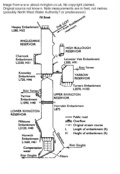
The Rivington Reservoirs (Lancashire) In 1850 John Bateman designed and built Chorley reservoir (aka High Bullough Reservoir) to supply water to Chorley. 1852-57: In the short space of just ten years, a further 7 reservoirs were designed and built by Thomas Hawkesley for Liverpool Water Company, who took over the earlier Chorley reservoir. The full sequence of reservoirs is Upper Roddlesworth · Lower Roddlesworth · Abbey Village · Rake Brook · The Goit (3 mile canal) · Anglezarke · High Bullough · Upper Rivington · Yarrow · Lower Rivington · Rivington Water Treatment Works. High Bullough (the original reservoir) and Yarrow are off to the side with Anglezarke, upper and lower Rivington forming an almost straight line. Today Chorley reservoir is essentially disconnected from the chain. The Roddlesworth reservoirs exist but seem to be resting- the once 21 foot wide canal is down to five feet wide in places. The highest embankment is that of the Yarrow reservoir, which is 103 feet above the bottom of the valley. The deepest puddle trench is also at this reservoir. Here the trench had to be carried down to a depth of 167 feet below the natural surface before a solid foundation could be obtained; the total height from the bottom of the foundation to the top of the dam being 257 feet. On the Rivington bank of the Lower Rivington reservoir is a folly which is a replica of Liverpool Castle. Schematic from www.about-rivington.co.uk, no copyright claimed by the web site, original source not known. |
totoro |
Monday 3rd of March 2014 05:58:17 PM |