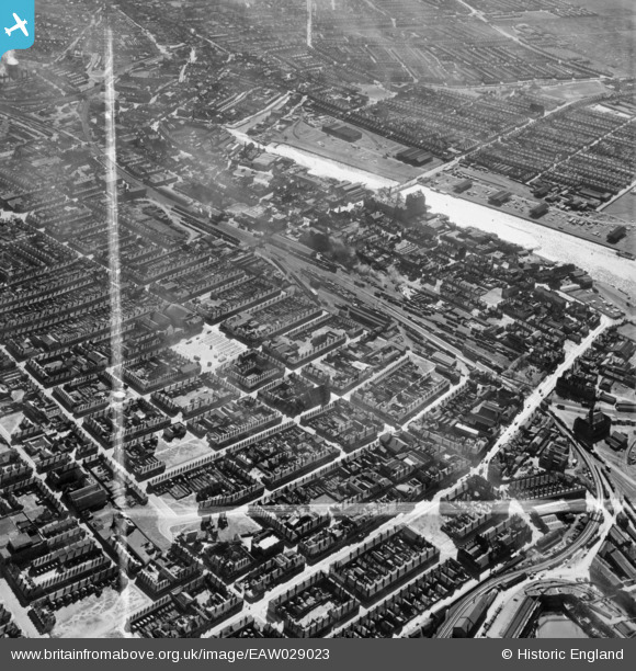
EAW029023 ENGLAND (1950). The town around Freeman Street Market and Grimsby Docks Railway Station, Grimsby, 1950. This image was marked by Aerofilms Ltd for photo editing.
© Copyright OpenStreetMap contributors and licensed by the OpenStreetMap Foundation. 2026. Cartography is licensed as CC BY-SA.
Nearby Images (16)
Details
| Title | [EAW029023] The town around Freeman Street Market and Grimsby Docks Railway Station, Grimsby, 1950. This image was marked by Aerofilms Ltd for photo editing. |
| Reference | EAW029023 |
| Date | 10-May-1950 |
| Link | |
| Place name | GRIMSBY |
| Parish | |
| District | |
| Country | ENGLAND |
| Easting / Northing | 527556, 410112 |
| Longitude / Latitude | -0.073471167388161, 53.571839520258 |
| National Grid Reference | TA276101 |
Pins

redmist |
Wednesday 31st of October 2018 07:56:09 PM | |

Beowolf |
Thursday 3rd of December 2015 10:01:13 PM | |

John Wass |
Sunday 2nd of November 2014 08:21:41 PM |


![[EAW029023] The town around Freeman Street Market and Grimsby Docks Railway Station, Grimsby, 1950. This image was marked by Aerofilms Ltd for photo editing.](http://britainfromabove.org.uk/sites/all/libraries/aerofilms-images/public/100x100/EAW/029/EAW029023.jpg)
![[EAW029024] The town around Grimsby Docks Railway Station, Grimsby, 1950. This image was marked by Aerofilms Ltd for photo editing.](http://britainfromabove.org.uk/sites/all/libraries/aerofilms-images/public/100x100/EAW/029/EAW029024.jpg)
![[EAW029025] The town around Grimsby Docks Railway Station, Grimsby, 1950. This image was marked by Aerofilms Ltd for photo editing.](http://britainfromabove.org.uk/sites/all/libraries/aerofilms-images/public/100x100/EAW/029/EAW029025.jpg)
![[EAW052055] The Osmond and Sons Ltd Railway Street Works, Duncombe Street and Freeman Street Market, Grimsby, 1953. This image was marked by Aerofilms Ltd for photo editing.](http://britainfromabove.org.uk/sites/all/libraries/aerofilms-images/public/100x100/EAW/052/EAW052055.jpg)
![[EAW052058] The Osmond and Sons Ltd Railway Street Works and environs, Grimsby, 1953. This image was marked by Aerofilms Ltd for photo editing.](http://britainfromabove.org.uk/sites/all/libraries/aerofilms-images/public/100x100/EAW/052/EAW052058.jpg)
![[EAW052365] Works off Railway Street and environs, Grimsby, 1953. This image was marked by Aerofilms Ltd for photo editing.](http://britainfromabove.org.uk/sites/all/libraries/aerofilms-images/public/100x100/EAW/052/EAW052365.jpg)
![[EAW052056] The Osmond and Sons Ltd Railway Street Works and environs, Grimsby, 1953. This image was marked by Aerofilms Ltd for photo editing.](http://britainfromabove.org.uk/sites/all/libraries/aerofilms-images/public/100x100/EAW/052/EAW052056.jpg)
![[EAW052368] Footbridge over the railway line linking Market Street with Newmarket Street, Grimsby, 1953. This image was marked by Aerofilms Ltd for photo editing.](http://britainfromabove.org.uk/sites/all/libraries/aerofilms-images/public/100x100/EAW/052/EAW052368.jpg)
![[EAW052059] The Osmond and Sons Ltd Railway Street Works, Grimsby, 1953. This image was marked by Aerofilms Ltd for photo editing.](http://britainfromabove.org.uk/sites/all/libraries/aerofilms-images/public/100x100/EAW/052/EAW052059.jpg)
![[EAW052367] Footbridge over the railway line linking Market Street with Newmarket Street, works off Railway Street and environs, Grimsby, 1953. This image was marked by Aerofilms Ltd for photo editing.](http://britainfromabove.org.uk/sites/all/libraries/aerofilms-images/public/100x100/EAW/052/EAW052367.jpg)
![[EAW052366] Footbridge over the railway line linking Market Street with Newmarket Street and environs, Grimsby, 1953. This image was marked by Aerofilms Ltd for photo editing.](http://britainfromabove.org.uk/sites/all/libraries/aerofilms-images/public/100x100/EAW/052/EAW052366.jpg)
![[EAW052057] The Osmond and Sons Ltd Railway Street Works and environs, Grimsby, 1953. This image was marked by Aerofilms Ltd for photo editing.](http://britainfromabove.org.uk/sites/all/libraries/aerofilms-images/public/100x100/EAW/052/EAW052057.jpg)
![[EPW053383] The streets around St Andrew's Church and the docks, Grimsby, 1937](http://britainfromabove.org.uk/sites/all/libraries/aerofilms-images/public/100x100/EPW/053/EPW053383.jpg)
![[EAW052364] Footbridge over the railway line linking Market Street with Newmarket Street, Grimsby, 1953. This image was marked by Aerofilms Ltd for photo editing.](http://britainfromabove.org.uk/sites/all/libraries/aerofilms-images/public/100x100/EAW/052/EAW052364.jpg)
![[EAW029028] Alexandra Dock and the town around Grimsby Docks Railway Station, Grimsby, 1950. This image was marked by Aerofilms Ltd for photo editing.](http://britainfromabove.org.uk/sites/all/libraries/aerofilms-images/public/100x100/EAW/029/EAW029028.jpg)
![[EPW053386] Freeman Street and environs, Grimsby, 1937](http://britainfromabove.org.uk/sites/all/libraries/aerofilms-images/public/100x100/EPW/053/EPW053386.jpg)