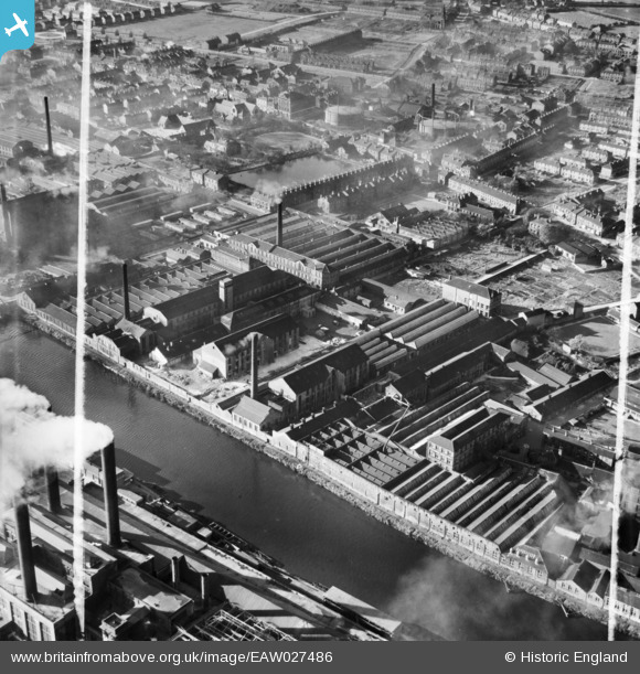
EAW027486 ENGLAND (1949). The Calder Vale Woollen Mill and the Ravensthorpe Woollen Mill, Ravensthorpe, 1949. This image was marked by Aerofilms Ltd for photo editing.
© Copyright OpenStreetMap contributors and licensed by the OpenStreetMap Foundation. 2026. Cartography is licensed as CC BY-SA.
Nearby Images (11)
Details
| Title | [EAW027486] The Calder Vale Woollen Mill and the Ravensthorpe Woollen Mill, Ravensthorpe, 1949. This image was marked by Aerofilms Ltd for photo editing. |
| Reference | EAW027486 |
| Date | 27-October-1949 |
| Link | |
| Place name | RAVENSTHORPE |
| Parish | |
| District | |
| Country | ENGLAND |
| Easting / Northing | 422686, 420230 |
| Longitude / Latitude | -1.6565233625638, 53.677813627848 |
| National Grid Reference | SE227202 |
Pins

Graham Cass |
Wednesday 25th of February 2015 06:31:06 PM | |

Graham Cass |
Wednesday 25th of February 2015 06:30:15 PM |


![[EAW027486] The Calder Vale Woollen Mill and the Ravensthorpe Woollen Mill, Ravensthorpe, 1949. This image was marked by Aerofilms Ltd for photo editing.](http://britainfromabove.org.uk/sites/all/libraries/aerofilms-images/public/100x100/EAW/027/EAW027486.jpg)
![[EAW027489] The Calder Vale Woollen Mill, Ravensthorpe, 1949. This image was marked by Aerofilms Ltd for photo editing.](http://britainfromabove.org.uk/sites/all/libraries/aerofilms-images/public/100x100/EAW/027/EAW027489.jpg)
![[EAW027492] The Calder Vale Woollen Mill and surrounding mills alongside the River Calder, Ravensthorpe, 1949. This image was marked by Aerofilms Ltd for photo editing.](http://britainfromabove.org.uk/sites/all/libraries/aerofilms-images/public/100x100/EAW/027/EAW027492.jpg)
![[EAW027488] The Calder Vale Woollen Mill and surrounding mills alongside the River Calder, Ravensthorpe, 1949. This image was marked by Aerofilms Ltd for photo editing.](http://britainfromabove.org.uk/sites/all/libraries/aerofilms-images/public/100x100/EAW/027/EAW027488.jpg)
![[EAW027487] The Calder Vale Woollen Mill and surrounding mills alongside the River Calder, Ravensthorpe, 1949. This image was marked by Aerofilms Ltd for photo editing.](http://britainfromabove.org.uk/sites/all/libraries/aerofilms-images/public/100x100/EAW/027/EAW027487.jpg)
![[EAW027494] The Calder Vale Woollen Mill and surrounding mills alongside the River Calder, Ravensthorpe, 1949. This image was marked by Aerofilms Ltd for photo editing.](http://britainfromabove.org.uk/sites/all/libraries/aerofilms-images/public/100x100/EAW/027/EAW027494.jpg)
![[EAW027493] The Calder Vale Woollen Mill and surrounding mills alongside the River Calder, Ravensthorpe, 1949. This image was marked by Aerofilms Ltd for photo editing.](http://britainfromabove.org.uk/sites/all/libraries/aerofilms-images/public/100x100/EAW/027/EAW027493.jpg)
![[EAW027485] The Calder Wharf Dyeing Mill and the Calder Vale Woollen Mill, Ravensthorpe, 1949. This image was marked by Aerofilms Ltd for photo editing.](http://britainfromabove.org.uk/sites/all/libraries/aerofilms-images/public/100x100/EAW/027/EAW027485.jpg)
![[EAW027491] The Calder Vale Woollen Mill and surrounding mills alongside the River Calder, Ravensthorpe, 1949. This image was marked by Aerofilms Ltd for photo editing.](http://britainfromabove.org.uk/sites/all/libraries/aerofilms-images/public/100x100/EAW/027/EAW027491.jpg)
![[EAW027490] The Calder Wharf Dyeing Mill and the Calder Vale Woollen Mill, Ravensthorpe, 1949. This image was marked by Aerofilms Ltd for photo editing.](http://britainfromabove.org.uk/sites/all/libraries/aerofilms-images/public/100x100/EAW/027/EAW027490.jpg)
![[EAW027484] The Calder Wharf Dyeing Mill and the Calder Vale Woollen Mill, Ravensthorpe, 1949. This image was marked by Aerofilms Ltd for photo editing.](http://britainfromabove.org.uk/sites/all/libraries/aerofilms-images/public/100x100/EAW/027/EAW027484.jpg)