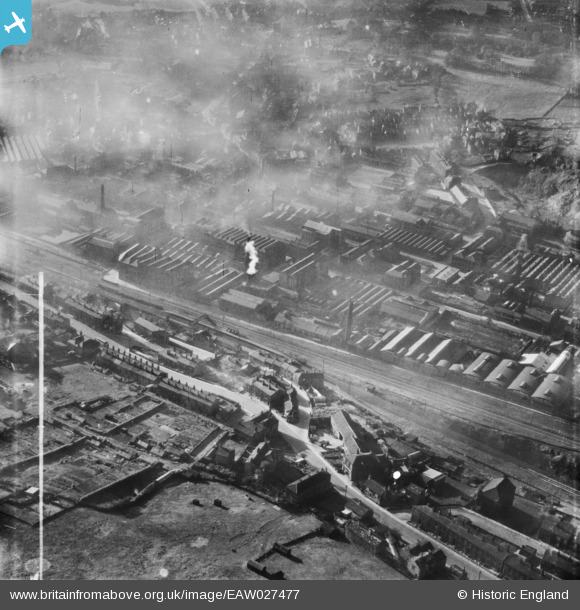
EAW027477 ENGLAND (1949). Woollen Mills along Bradford Road East, Batley, 1949. This image was marked by Aerofilms Ltd for photo editing.
© Copyright OpenStreetMap contributors and licensed by the OpenStreetMap Foundation. 2026. Cartography is licensed as CC BY-SA.
Nearby Images (12)
Details
| Title | [EAW027477] Woollen Mills along Bradford Road East, Batley, 1949. This image was marked by Aerofilms Ltd for photo editing. |
| Reference | EAW027477 |
| Date | 27-October-1949 |
| Link | |
| Place name | BATLEY |
| Parish | |
| District | |
| Country | ENGLAND |
| Easting / Northing | 424591, 422956 |
| Longitude / Latitude | -1.6274651719799, 53.702231419093 |
| National Grid Reference | SE246230 |
Pins

Cabby |
Friday 17th of April 2015 08:42:23 AM | |

Cabby |
Friday 17th of April 2015 08:39:08 AM | |

Cabby |
Sunday 16th of February 2014 09:41:16 AM | |

Cabby |
Sunday 16th of February 2014 09:38:45 AM | |

Cabby |
Sunday 16th of February 2014 09:37:55 AM | |

Cabby |
Sunday 16th of February 2014 09:36:16 AM | |

Cabby |
Sunday 16th of February 2014 09:35:14 AM | |

Cabby |
Sunday 16th of February 2014 09:34:11 AM |


![[EAW027477] Woollen Mills along Bradford Road East, Batley, 1949. This image was marked by Aerofilms Ltd for photo editing.](http://britainfromabove.org.uk/sites/all/libraries/aerofilms-images/public/100x100/EAW/027/EAW027477.jpg)
![[EAW027478] Woollen Mills along Bradford Road East, Batley, 1949. This image was marked by Aerofilms Ltd for photo editing.](http://britainfromabove.org.uk/sites/all/libraries/aerofilms-images/public/100x100/EAW/027/EAW027478.jpg)
![[EAW027476] Woollen Mills along Bradford Road East, Batley, 1949. This image was marked by Aerofilms Ltd for photo editing.](http://britainfromabove.org.uk/sites/all/libraries/aerofilms-images/public/100x100/EAW/027/EAW027476.jpg)
![[EAW027479] Woollen Mills along Bradford Road East, Batley, 1949. This image was marked by Aerofilms Ltd for photo editing.](http://britainfromabove.org.uk/sites/all/libraries/aerofilms-images/public/100x100/EAW/027/EAW027479.jpg)
![[EAW027480] Woollen Mills surrounding Bradford Road East and the Batley Cricket, Athletic and Football Grounds, Batley, 1949. This image was marked by Aerofilms Ltd for photo editing.](http://britainfromabove.org.uk/sites/all/libraries/aerofilms-images/public/100x100/EAW/027/EAW027480.jpg)
![[EAW027481] Woollen Mills surrounding Bradford Road East, Batley, 1949. This image was marked by Aerofilms Ltd for photo editing.](http://britainfromabove.org.uk/sites/all/libraries/aerofilms-images/public/100x100/EAW/027/EAW027481.jpg)
![[EAW027474] Woollen Mills surrounding Bradford Road East and the Batley Cricket, Athletic and Football Grounds, Batley, 1949. This image was marked by Aerofilms Ltd for photo editing.](http://britainfromabove.org.uk/sites/all/libraries/aerofilms-images/public/100x100/EAW/027/EAW027474.jpg)
![[EAW027475] The Livingstone and the Ings Woollen Mills, Batley, 1949. This image was marked by Aerofilms Ltd for photo editing.](http://britainfromabove.org.uk/sites/all/libraries/aerofilms-images/public/100x100/EAW/027/EAW027475.jpg)
![[EAW027473] The Livingstone and the Ings Woollen Mills, Batley, 1949. This image was marked by Aerofilms Ltd for photo editing.](http://britainfromabove.org.uk/sites/all/libraries/aerofilms-images/public/100x100/EAW/027/EAW027473.jpg)
![[EAW027483] Woollen Mills surrounding Bradford Road East and the Atlas Brick Works, Batley, 1949. This image was marked by Aerofilms Ltd for photo editing.](http://britainfromabove.org.uk/sites/all/libraries/aerofilms-images/public/100x100/EAW/027/EAW027483.jpg)
![[EAW027472] Woollen Mills alongside Bradford Road East, Batley, from the south, 1949. This image was marked by Aerofilms Ltd for photo editing.](http://britainfromabove.org.uk/sites/all/libraries/aerofilms-images/public/100x100/EAW/027/EAW027472.jpg)
![[EAW027482] Woollen Mills surrounding Bradford Road East and the residential area opposite, Batley, 1949. This image was marked by Aerofilms Ltd for photo editing.](http://britainfromabove.org.uk/sites/all/libraries/aerofilms-images/public/100x100/EAW/027/EAW027482.jpg)