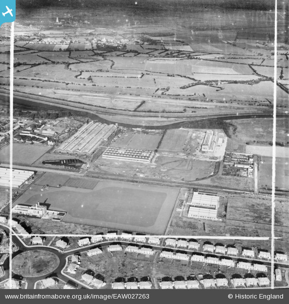
EAW027263 ENGLAND (1949). The International Harvester Factory on Wheatley Hall Road and environs, Doncaster, 1949. This image was marked by Aerofilms Ltd for photo editing.
© Copyright OpenStreetMap contributors and licensed by the OpenStreetMap Foundation. 2025. Cartography is licensed as CC BY-SA.
Nearby Images (19)
Details
| Title | [EAW027263] The International Harvester Factory on Wheatley Hall Road and environs, Doncaster, 1949. This image was marked by Aerofilms Ltd for photo editing. |
| Reference | EAW027263 |
| Date | 19-October-1949 |
| Link | |
| Place name | DONCASTER |
| Parish | |
| District | |
| Country | ENGLAND |
| Easting / Northing | 459376, 405657 |
| Longitude / Latitude | -1.1038493218225, 53.543947718931 |
| National Grid Reference | SE594057 |


![[EAW027263] The International Harvester Factory on Wheatley Hall Road and environs, Doncaster, 1949. This image was marked by Aerofilms Ltd for photo editing.](http://britainfromabove.org.uk/sites/all/libraries/aerofilms-images/public/100x100/EAW/027/EAW027263.jpg)
![[EAW038716] The International Harvester Factory off Wheatley Hall Road, Doncaster, 1951. This image has been produced from a print.](http://britainfromabove.org.uk/sites/all/libraries/aerofilms-images/public/100x100/EAW/038/EAW038716.jpg)
![[EAW027261] The International Harvester Factory on Wheatley Hall Road, Doncaster, 1949. This image was marked by Aerofilms Ltd for photo editing.](http://britainfromabove.org.uk/sites/all/libraries/aerofilms-images/public/100x100/EAW/027/EAW027261.jpg)
![[EAW038713] The International Harvester Factory off Wheatley Hall Road and environs, Doncaster, 1951. This image has been produced from a print.](http://britainfromabove.org.uk/sites/all/libraries/aerofilms-images/public/100x100/EAW/038/EAW038713.jpg)
![[EAW027268] The International Harvester Factory on Wheatley Hall Road, Doncaster, from the south-west, 1949. This image has been produced from a print marked by Aerofilms Ltd for photo editing.](http://britainfromabove.org.uk/sites/all/libraries/aerofilms-images/public/100x100/EAW/027/EAW027268.jpg)
![[EAW038708] The International Harvester Factory off Wheatley Hall Road, Doncaster, 1951. This image has been produced from a print marked by Aerofilms Ltd for photo editing.](http://britainfromabove.org.uk/sites/all/libraries/aerofilms-images/public/100x100/EAW/038/EAW038708.jpg)
![[EAW038718] The International Harvester Factory off Wheatley Hall Road, Doncaster, 1951. This image has been produced from a print.](http://britainfromabove.org.uk/sites/all/libraries/aerofilms-images/public/100x100/EAW/038/EAW038718.jpg)
![[EAW027262] The International Harvester Factory on Wheatley Hall Road, Doncaster, 1949. This image was marked by Aerofilms Ltd for photo editing.](http://britainfromabove.org.uk/sites/all/libraries/aerofilms-images/public/100x100/EAW/027/EAW027262.jpg)
![[EAW038717] The International Harvester Factory off Wheatley Hall Road, Doncaster, 1951. This image has been produced from a print.](http://britainfromabove.org.uk/sites/all/libraries/aerofilms-images/public/100x100/EAW/038/EAW038717.jpg)
![[EAW038709] The International Harvester Factory off Wheatley Hall Road, Doncaster, 1951. This image has been produced from a print marked by Aerofilms Ltd for photo editing.](http://britainfromabove.org.uk/sites/all/libraries/aerofilms-images/public/100x100/EAW/038/EAW038709.jpg)
![[EAW027264] The International Harvester Factory on Wheatley Hall Road, Doncaster, 1949. This image was marked by Aerofilms Ltd for photo editing.](http://britainfromabove.org.uk/sites/all/libraries/aerofilms-images/public/100x100/EAW/027/EAW027264.jpg)
![[EAW038714] The International Harvester Factory off Wheatley Hall Road, Doncaster, 1951. This image has been produced from a print.](http://britainfromabove.org.uk/sites/all/libraries/aerofilms-images/public/100x100/EAW/038/EAW038714.jpg)
![[EAW027260] The International Harvester Factory on Wheatley Hall Road, Doncaster, 1949. This image was marked by Aerofilms Ltd for photo editing.](http://britainfromabove.org.uk/sites/all/libraries/aerofilms-images/public/100x100/EAW/027/EAW027260.jpg)
![[EAW027266] The International Harvester Factory on Wheatley Hall Road, Doncaster, from the south-west, 1949. This image was marked by Aerofilms Ltd for photo editing.](http://britainfromabove.org.uk/sites/all/libraries/aerofilms-images/public/100x100/EAW/027/EAW027266.jpg)
![[EAW027267] The International Harvester Factory on Wheatley Hall Road, Doncaster, from the south-west, 1949. This image has been produced from a print marked by Aerofilms Ltd for photo editing.](http://britainfromabove.org.uk/sites/all/libraries/aerofilms-images/public/100x100/EAW/027/EAW027267.jpg)
![[EAW038710] The International Harvester Factory off Wheatley Hall Road and environs, Doncaster, from the south-west, 1951. This image has been produced from a print.](http://britainfromabove.org.uk/sites/all/libraries/aerofilms-images/public/100x100/EAW/038/EAW038710.jpg)
![[EAW038711] The International Harvester Factory off Wheatley Hall Road, Doncaster, 1951. This image has been produced from a print.](http://britainfromabove.org.uk/sites/all/libraries/aerofilms-images/public/100x100/EAW/038/EAW038711.jpg)
![[EAW038712] The International Harvester Factory off Wheatley Hall Road and environs, Doncaster, from the south, 1951. This image has been produced from a print.](http://britainfromabove.org.uk/sites/all/libraries/aerofilms-images/public/100x100/EAW/038/EAW038712.jpg)
![[EAW038715] The International Harvester Factory off Wheatley Hall Road, Doncaster, 1951. This image has been produced from a print.](http://britainfromabove.org.uk/sites/all/libraries/aerofilms-images/public/100x100/EAW/038/EAW038715.jpg)
