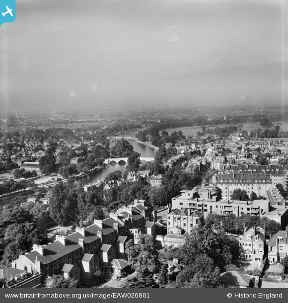
EAW026801 ENGLAND (1949). Richmond Hill looking towards Richmond Bridge, Richmond, from the south-east, 1949
© Copyright OpenStreetMap contributors and licensed by the OpenStreetMap Foundation. 2026. Cartography is licensed as CC BY-SA.
Nearby Images (10)
Details
| Title | [EAW026801] Richmond Hill looking towards Richmond Bridge, Richmond, from the south-east, 1949 |
| Reference | EAW026801 |
| Date | 3-October-1949 |
| Link | |
| Place name | RICHMOND |
| Parish | |
| District | |
| Country | ENGLAND |
| Easting / Northing | 518269, 174138 |
| Longitude / Latitude | -0.29766595874471, 51.453366314487 |
| National Grid Reference | TQ183741 |
Pins
Be the first to add a comment to this image!


![[EAW026801] Richmond Hill looking towards Richmond Bridge, Richmond, from the south-east, 1949](http://britainfromabove.org.uk/sites/all/libraries/aerofilms-images/public/100x100/EAW/026/EAW026801.jpg)
![[EPW036446] The British Legion Poppy Factory, Terrace Gardens and environs, Richmond, 1931](http://britainfromabove.org.uk/sites/all/libraries/aerofilms-images/public/100x100/EPW/036/EPW036446.jpg)
![[EPW022841] Bridges over the River Thames, Richmond, from the south-east, 1928](http://britainfromabove.org.uk/sites/all/libraries/aerofilms-images/public/100x100/EPW/022/EPW022841.jpg)
![[EPW036447] The British Legion Poppy Factory, Terrace Gardens and environs, Richmond, 1931](http://britainfromabove.org.uk/sites/all/libraries/aerofilms-images/public/100x100/EPW/036/EPW036447.jpg)
![[EPR000468] Richmond Hill Court and environs, Richmond Hill, 1935](http://britainfromabove.org.uk/sites/all/libraries/aerofilms-images/public/100x100/EPR/000/EPR000468.jpg)
![[EAW006953] The house of Sir John Archer alongside Terrace Field, Richmond Hill, 1947](http://britainfromabove.org.uk/sites/all/libraries/aerofilms-images/public/100x100/EAW/006/EAW006953.jpg)
![[EPW036444] The British Legion Poppy Factory, Richmond Hill and environs, Richmond, 1931](http://britainfromabove.org.uk/sites/all/libraries/aerofilms-images/public/100x100/EPW/036/EPW036444.jpg)
![[EPW036450] The British Legion Poppy Factory, the River Thames and Richmond Hill, Richmond, 1931](http://britainfromabove.org.uk/sites/all/libraries/aerofilms-images/public/100x100/EPW/036/EPW036450.jpg)
![[EAW006960] The house of Sir John Archer alongside Terrace Field, Richmond Hill, 1947](http://britainfromabove.org.uk/sites/all/libraries/aerofilms-images/public/100x100/EAW/006/EAW006960.jpg)
![[EPW036443] The British Legion Poppy Factory, the River Thames and Richmond Hill, Richmond, 1931](http://britainfromabove.org.uk/sites/all/libraries/aerofilms-images/public/100x100/EPW/036/EPW036443.jpg)