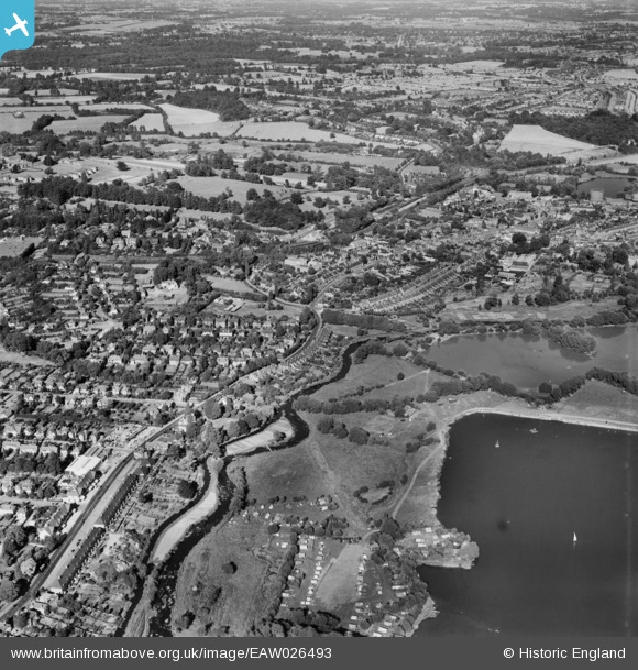
EAW026493 ENGLAND (1949). Money Hill and the town, Rickmansworth, from the south-west, 1949
© Copyright OpenStreetMap contributors and licensed by the OpenStreetMap Foundation. 2026. Cartography is licensed as CC BY-SA.
Details
| Title | [EAW026493] Money Hill and the town, Rickmansworth, from the south-west, 1949 |
| Reference | EAW026493 |
| Date | 10-September-1949 |
| Link | |
| Place name | RICKMANSWORTH |
| Parish | |
| District | |
| Country | ENGLAND |
| Easting / Northing | 505274, 194083 |
| Longitude / Latitude | -0.47866922859948, 51.635223497682 |
| National Grid Reference | TQ053941 |
Pins

LesMead |
Sunday 9th of May 2021 12:30:50 PM | |

LesMead |
Sunday 9th of May 2021 12:21:35 PM | |

LesMead |
Sunday 9th of May 2021 12:19:35 PM | |

LesMead |
Sunday 9th of May 2021 12:17:43 PM | |

N Gardner |
Saturday 8th of September 2018 05:02:06 PM | |

The Laird |
Saturday 23rd of July 2016 01:53:40 PM | |

The Laird |
Thursday 30th of April 2015 12:09:00 PM | |

The Laird |
Thursday 30th of April 2015 11:59:29 AM | |

This is six |
Monday 7th of April 2014 02:32:04 PM | |

This is six |
Monday 7th of April 2014 02:29:47 PM | |

Neil Hamilton |
Tuesday 18th of February 2014 08:52:06 PM |


![[EAW026493] Money Hill and the town, Rickmansworth, from the south-west, 1949](http://britainfromabove.org.uk/sites/all/libraries/aerofilms-images/public/100x100/EAW/026/EAW026493.jpg)
![[EAW026494] Bury Lake and environs, Rickmansworth, 1949](http://britainfromabove.org.uk/sites/all/libraries/aerofilms-images/public/100x100/EAW/026/EAW026494.jpg)
![[EPW044210] Campsite adjacent to Bury Lake, Rickmansworth, 1934](http://britainfromabove.org.uk/sites/all/libraries/aerofilms-images/public/100x100/EPW/044/EPW044210.jpg)
![[EPW044209] Campsite adjacent to Bury Lake, Rickmansworth, 1934](http://britainfromabove.org.uk/sites/all/libraries/aerofilms-images/public/100x100/EPW/044/EPW044209.jpg)