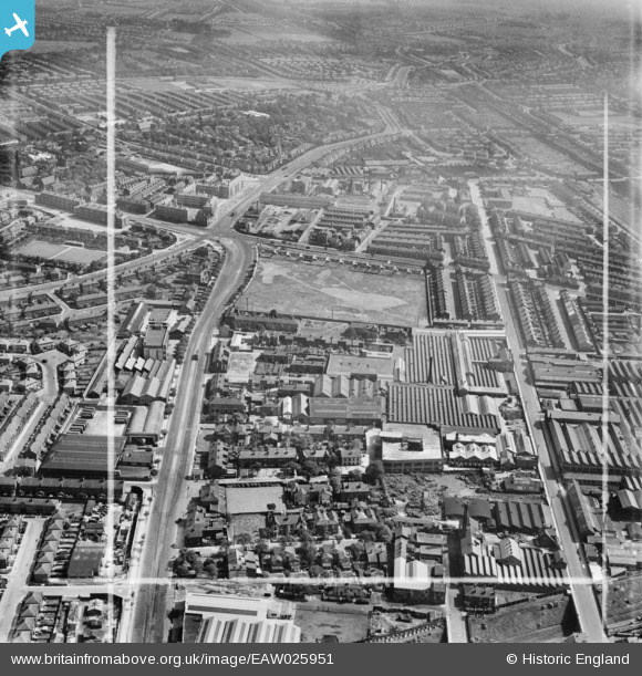
EAW025951 ENGLAND (1949). The Paton, Calvert and Co Hardware Factory, Liverpool, 1949. This image was marked by Aerofilms Ltd for photo editing.
© Copyright OpenStreetMap contributors and licensed by the OpenStreetMap Foundation. 2026. Cartography is licensed as CC BY-SA.
Nearby Images (22)
Details
| Title | [EAW025951] The Paton, Calvert and Co Hardware Factory, Liverpool, 1949. This image was marked by Aerofilms Ltd for photo editing. |
| Reference | EAW025951 |
| Date | 14-August-1949 |
| Link | |
| Place name | LIVERPOOL |
| Parish | |
| District | |
| Country | ENGLAND |
| Easting / Northing | 338895, 390664 |
| Longitude / Latitude | -2.9193248889545, 53.408987239241 |
| National Grid Reference | SJ389907 |
Pins

BruceR |
Saturday 4th of December 2021 08:58:15 PM | |

BruceR |
Saturday 4th of December 2021 08:54:48 PM | |

redmist |
Sunday 14th of February 2021 09:33:11 PM | |

redmist |
Sunday 14th of February 2021 09:32:13 PM | |

redmist |
Sunday 14th of February 2021 09:31:23 PM | |

Bashey |
Wednesday 14th of October 2020 02:03:27 PM | |

BruceR |
Thursday 20th of December 2018 09:20:42 PM | |

BruceR |
Thursday 20th of December 2018 09:17:22 PM |


![[EAW025951] The Paton, Calvert and Co Hardware Factory, Liverpool, 1949. This image was marked by Aerofilms Ltd for photo editing.](http://britainfromabove.org.uk/sites/all/libraries/aerofilms-images/public/100x100/EAW/025/EAW025951.jpg)
![[EAW025950] The Paton, Calvert and Co Hardware Factory, Liverpool, 1949. This image was marked by Aerofilms Ltd for photo editing.](http://britainfromabove.org.uk/sites/all/libraries/aerofilms-images/public/100x100/EAW/025/EAW025950.jpg)
![[EPW044469] Paton, Calvert and Co Mechanical Toy Works, the Matchless Metal Polish Works and environs, Old Swan, 1934](http://britainfromabove.org.uk/sites/all/libraries/aerofilms-images/public/100x100/EPW/044/EPW044469.jpg)
![[EPW044472] Paton, Calvert and Co Mechanical Toy Works, and the Matchless Metal Polish Works on Binns Road, Old Swan, 1934](http://britainfromabove.org.uk/sites/all/libraries/aerofilms-images/public/100x100/EPW/044/EPW044472.jpg)
![[EAW025949] The Paton, Calvert and Co Hardware Factory and the Stanley Greyhound Racing Track, Liverpool, from the south-east, 1949. This image was marked by Aerofilms Ltd for photo editing.](http://britainfromabove.org.uk/sites/all/libraries/aerofilms-images/public/100x100/EAW/025/EAW025949.jpg)
![[EPW044471] Paton, Calvert and Co Mechanical Toy Works, the Matchless Metal Polish Works on Binns Road and environs, Old Swan, 1934](http://britainfromabove.org.uk/sites/all/libraries/aerofilms-images/public/100x100/EPW/044/EPW044471.jpg)
![[EPW044470] Paton, Calvert and Co Mechanical Toy Works and the Matchless Metal Polish Works on Binns Road, Old Swan, 1934](http://britainfromabove.org.uk/sites/all/libraries/aerofilms-images/public/100x100/EPW/044/EPW044470.jpg)
![[EAW042550] The Meccano Ltd Toy Factory on Binns Road, Liverpool, 1952. This image was marked by Aerofilms Ltd for photo editing.](http://britainfromabove.org.uk/sites/all/libraries/aerofilms-images/public/100x100/EAW/042/EAW042550.jpg)
![[EAW025953] The Paton, Calvert and Co Hardware Factory, Liverpool, from the south, 1949. This image was marked by Aerofilms Ltd for photo editing.](http://britainfromabove.org.uk/sites/all/libraries/aerofilms-images/public/100x100/EAW/025/EAW025953.jpg)
![[EAW025954] The Paton, Calvert and Co Hardware Factory, Liverpool, 1949. This image was marked by Aerofilms Ltd for photo editing.](http://britainfromabove.org.uk/sites/all/libraries/aerofilms-images/public/100x100/EAW/025/EAW025954.jpg)
![[EAW025952] The Paton, Calvert and Co Hardware Factory, Liverpool, from the south, 1949. This image was marked by Aerofilms Ltd for photo editing.](http://britainfromabove.org.uk/sites/all/libraries/aerofilms-images/public/100x100/EAW/025/EAW025952.jpg)
![[EAW042545] The Meccano Ltd Toy Factory on Binns Road, Liverpool, 1952. This image was marked by Aerofilms Ltd for photo editing.](http://britainfromabove.org.uk/sites/all/libraries/aerofilms-images/public/100x100/EAW/042/EAW042545.jpg)
![[EAW042552] The Meccano Ltd Toy Factory on Binns Road, Liverpool, 1952. This image was marked by Aerofilms Ltd for photo editing.](http://britainfromabove.org.uk/sites/all/libraries/aerofilms-images/public/100x100/EAW/042/EAW042552.jpg)
![[EAW042547] The Meccano Ltd Toy Factory on Binns Road, Liverpool, 1952. This image was marked by Aerofilms Ltd for photo editing.](http://britainfromabove.org.uk/sites/all/libraries/aerofilms-images/public/100x100/EAW/042/EAW042547.jpg)
![[EAW042546] The Meccano Ltd Toy Factory on Binns Road, Liverpool, 1952. This image was marked by Aerofilms Ltd for photo editing.](http://britainfromabove.org.uk/sites/all/libraries/aerofilms-images/public/100x100/EAW/042/EAW042546.jpg)
![[EAW042549] The Meccano Ltd Toy Factory on Binns Road, Liverpool, 1952. This image was marked by Aerofilms Ltd for photo editing.](http://britainfromabove.org.uk/sites/all/libraries/aerofilms-images/public/100x100/EAW/042/EAW042549.jpg)
![[EAW042554] The Meccano Ltd Toy Factory on Binns Road, Liverpool, 1952. This image was marked by Aerofilms Ltd for photo editing.](http://britainfromabove.org.uk/sites/all/libraries/aerofilms-images/public/100x100/EAW/042/EAW042554.jpg)
![[EAW025948] The Paton, Calvert and Co Hardware Factory, Liverpool, from the south-west, 1949](http://britainfromabove.org.uk/sites/all/libraries/aerofilms-images/public/100x100/EAW/025/EAW025948.jpg)
![[EAW042544] The Meccano Ltd Toy Factory on Binns Road, Liverpool, 1952. This image was marked by Aerofilms Ltd for photo editing.](http://britainfromabove.org.uk/sites/all/libraries/aerofilms-images/public/100x100/EAW/042/EAW042544.jpg)
![[EAW042548] The Meccano Ltd Toy Factory on Binns Road, Liverpool, 1952. This image was marked by Aerofilms Ltd for photo editing.](http://britainfromabove.org.uk/sites/all/libraries/aerofilms-images/public/100x100/EAW/042/EAW042548.jpg)
![[EAW042553] The Meccano Ltd Toy Factory on Binns Road, Liverpool, 1952. This image was marked by Aerofilms Ltd for photo editing.](http://britainfromabove.org.uk/sites/all/libraries/aerofilms-images/public/100x100/EAW/042/EAW042553.jpg)
![[EAW042551] The Meccano Ltd Toy Factory on Binns Road, Liverpool, 1952. This image was marked by Aerofilms Ltd for photo editing.](http://britainfromabove.org.uk/sites/all/libraries/aerofilms-images/public/100x100/EAW/042/EAW042551.jpg)