
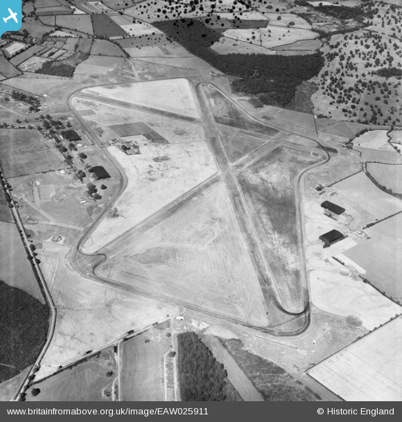
EAW025911 ENGLAND (1949). Silverstone Motor Racing Circuit, Lillingstone Dayrell, 1949
© Copyright OpenStreetMap contributors and licensed by the OpenStreetMap Foundation. 2026. Cartography is licensed as CC BY-SA.
Nearby Images (2)
EAW025911

EAW025909

Details
| Title | [EAW025911] Silverstone Motor Racing Circuit, Lillingstone Dayrell, 1949 |
| Reference | EAW025911 |
| Date | 15-August-1949 |
| Link | |
| Place name | LILLINGSTONE DAYRELL |
| Parish | LILLINGSTONE DAYRELL WITH LUFFIELD ABBEY |
| District | |
| Country | ENGLAND |
| Easting / Northing | 467494, 241685 |
| Longitude / Latitude | -1.0152257766273, 52.0689999681 |
| National Grid Reference | SP675417 |
Pins

rac |
Sunday 20th of September 2020 10:54:59 PM | |
|
cptpies |
Tuesday 7th of January 2014 09:42:32 AM | |
|
J May |
Thursday 19th of December 2013 01:36:50 PM | |
|
J May |
Thursday 19th of December 2013 01:36:32 PM | |
|
J May |
Thursday 19th of December 2013 01:36:11 PM | |
|
J May |
Thursday 19th of December 2013 01:35:58 PM | |
The black rubber line must be the racing line through Club chicane. In 1949 the Club chicane was dropped, leaving the fast Club corner. |
J May |
Thursday 19th of December 2013 01:48:08 PM |
|
J May |
Thursday 19th of December 2013 01:35:42 PM | |
|
J May |
Thursday 19th of December 2013 01:35:20 PM | |
|
J May |
Thursday 19th of December 2013 01:34:59 PM | |
|
J May |
Thursday 19th of December 2013 01:34:34 PM | |
|
J May |
Thursday 19th of December 2013 01:34:15 PM | |
|
J May |
Thursday 19th of December 2013 01:33:48 PM |
User Comment Contributions
Excellent view of the entire original Silverstone circuit, photograph taken only 1 year after it was first used. |
Scorrybreck |
Sunday 16th of March 2014 09:04:25 PM |
The RAF station was used by No 17 Operational Training Unit. Vickers Wellington bombers were based here in World War II. [Wikipedia] |
MB |
Sunday 15th of December 2013 10:34:51 PM |