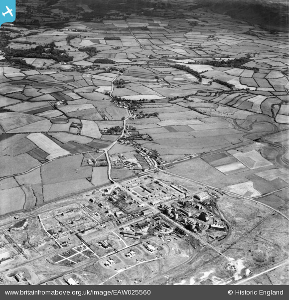
EAW025560 ENGLAND (1949). Royal Ordnance Factory (ROF) Drigg and environs, Drigg, from the south-west, 1949
© Copyright OpenStreetMap contributors and licensed by the OpenStreetMap Foundation. 2026. Cartography is licensed as CC BY-SA.
Details
| Title | [EAW025560] Royal Ordnance Factory (ROF) Drigg and environs, Drigg, from the south-west, 1949 |
| Reference | EAW025560 |
| Date | 3-August-1949 |
| Link | |
| Place name | DRIGG |
| Parish | DRIGG AND CARLETON |
| District | |
| Country | ENGLAND |
| Easting / Northing | 306248, 498905 |
| Longitude / Latitude | -3.4435023557804, 54.376859885689 |
| National Grid Reference | SD062989 |
Pins

Matt Aldred edob.mattaldred.com |
Thursday 8th of May 2025 03:56:47 PM | |

Matt Aldred edob.mattaldred.com |
Tuesday 9th of March 2021 11:33:04 AM | |

redmist |
Sunday 7th of February 2021 10:38:21 PM | |

redmist |
Sunday 7th of February 2021 10:34:35 PM | |

redmist |
Sunday 7th of February 2021 10:34:06 PM | |

redmist |
Sunday 7th of February 2021 10:33:50 PM | |

redmist |
Sunday 7th of February 2021 10:33:22 PM | |

cptpies |
Tuesday 4th of March 2014 12:51:55 PM | |

cptpies |
Tuesday 4th of March 2014 12:51:39 PM | |

cptpies |
Tuesday 4th of March 2014 12:51:22 PM | |

cptpies |
Tuesday 4th of March 2014 12:50:53 PM | |

cptpies |
Tuesday 4th of March 2014 12:50:30 PM | |

cptpies |
Tuesday 4th of March 2014 12:50:05 PM | |

cptpies |
Tuesday 4th of March 2014 12:49:44 PM | |

MB |
Thursday 19th of December 2013 10:17:23 PM | |

MB |
Thursday 19th of December 2013 10:14:45 PM | |

MB |
Thursday 19th of December 2013 10:14:04 PM |
User Comment Contributions

cptpies |
Tuesday 4th of March 2014 12:52:46 PM |


![[EAW025560] Royal Ordnance Factory (ROF) Drigg and environs, Drigg, from the south-west, 1949](http://britainfromabove.org.uk/sites/all/libraries/aerofilms-images/public/100x100/EAW/025/EAW025560.jpg)
![[EAW025559] Royal Ordnance Factory (ROF) Drigg and environs, Drigg, from the west, 1949. This image has been produced from a damaged negative.](http://britainfromabove.org.uk/sites/all/libraries/aerofilms-images/public/100x100/EAW/025/EAW025559.jpg)
