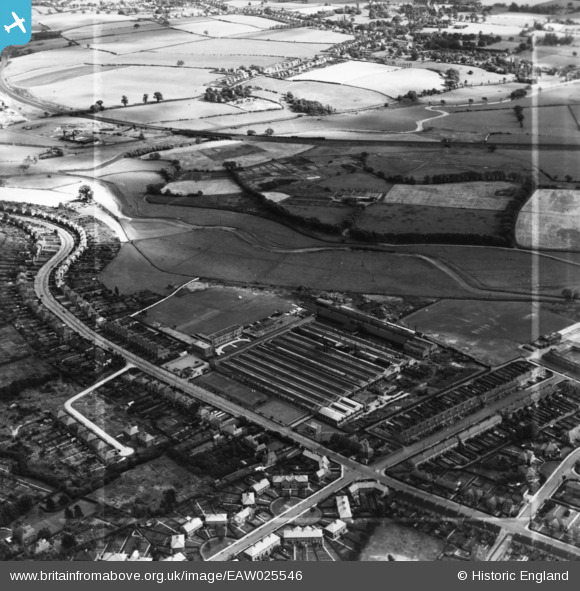
EAW025546 ENGLAND (1949). The W. H. Dorman and Co Ltd Engineering Works and Tixall Road, Stafford, 1949. This image has been produced from a print marked by Aerofilms Ltd for photo editing.
© Copyright OpenStreetMap contributors and licensed by the OpenStreetMap Foundation. 2026. Cartography is licensed as CC BY-SA.
Nearby Images (29)
Details
| Title | [EAW025546] The W. H. Dorman and Co Ltd Engineering Works and Tixall Road, Stafford, 1949. This image has been produced from a print marked by Aerofilms Ltd for photo editing. |
| Reference | EAW025546 |
| Date | 3-August-1949 |
| Link | |
| Place name | STAFFORD |
| Parish | |
| District | |
| Country | ENGLAND |
| Easting / Northing | 393725, 323018 |
| Longitude / Latitude | -2.093091425576, 52.804348056494 |
| National Grid Reference | SJ937230 |
Pins
Be the first to add a comment to this image!


![[EAW025546] The W. H. Dorman and Co Ltd Engineering Works and Tixall Road, Stafford, 1949. This image has been produced from a print marked by Aerofilms Ltd for photo editing.](http://britainfromabove.org.uk/sites/all/libraries/aerofilms-images/public/100x100/EAW/025/EAW025546.jpg)
![[EAW025543] The W. H. Dorman and Co Ltd Engineering Works and Tixall Road, Stafford, 1949. This image has been produced from a print marked by Aerofilms Ltd for photo editing.](http://britainfromabove.org.uk/sites/all/libraries/aerofilms-images/public/100x100/EAW/025/EAW025543.jpg)
![[EAW025541] The W. H. Dorman and Co Ltd Engineering Works, Stafford, from the south-east, 1949. This image has been produced from a print marked by Aerofilms Ltd for photo editing.](http://britainfromabove.org.uk/sites/all/libraries/aerofilms-images/public/100x100/EAW/025/EAW025541.jpg)
![[EAW025985] The W.H. Dorman and Co Tixall Road Engineering Works, Littleworth, 1949. This image has been produced from a print marked by Aerofilms Ltd for photo editing.](http://britainfromabove.org.uk/sites/all/libraries/aerofilms-images/public/100x100/EAW/025/EAW025985.jpg)
![[EAW025988] The W.H. Dorman and Co Tixall Road Engineering Works, Littleworth, 1949. This image has been produced from a print marked by Aerofilms Ltd for photo editing.](http://britainfromabove.org.uk/sites/all/libraries/aerofilms-images/public/100x100/EAW/025/EAW025988.jpg)
![[EAW036594] The W. H. Dorman and Co Ltd Tixall Road Engineering Works, Littleworth, 1951. This image has been produced from a print marked by Aerofilms Ltd for photo editing.](http://britainfromabove.org.uk/sites/all/libraries/aerofilms-images/public/100x100/EAW/036/EAW036594.jpg)
![[EAW036600] The W. H. Dorman and Co Ltd Tixall Road Engineering Works, Littleworth, 1951. This image has been produced from a print marked by Aerofilms Ltd for photo editing.](http://britainfromabove.org.uk/sites/all/libraries/aerofilms-images/public/100x100/EAW/036/EAW036600.jpg)
![[EAW036596] The W. H. Dorman and Co Ltd Tixall Road Engineering Works, Littleworth, 1951. This image has been produced from a print.](http://britainfromabove.org.uk/sites/all/libraries/aerofilms-images/public/100x100/EAW/036/EAW036596.jpg)
![[EAW036592] The W. H. Dorman and Co Ltd Tixall Road Engineering Works, Littleworth, 1951. This image has been produced from a print marked by Aerofilms Ltd for photo editing.](http://britainfromabove.org.uk/sites/all/libraries/aerofilms-images/public/100x100/EAW/036/EAW036592.jpg)
![[EAW025548] The W. H. Dorman and Co Ltd Engineering Works, Stafford, 1949. This image has been produced from a print marked by Aerofilms Ltd for photo editing.](http://britainfromabove.org.uk/sites/all/libraries/aerofilms-images/public/100x100/EAW/025/EAW025548.jpg)
![[EAW025542] The W. H. Dorman and Co Ltd Engineering Works, Stafford, 1949. This image has been produced from a print marked by Aerofilms Ltd for photo editing.](http://britainfromabove.org.uk/sites/all/libraries/aerofilms-images/public/100x100/EAW/025/EAW025542.jpg)
![[EAW036597] The W. H. Dorman and Co Ltd Tixall Road Engineering Works, Littleworth, 1951. This image has been produced from a print marked by Aerofilms Ltd for photo editing.](http://britainfromabove.org.uk/sites/all/libraries/aerofilms-images/public/100x100/EAW/036/EAW036597.jpg)
![[EPW056769] The W. H. Dorman and Co Tixall Road Engineering Works, Littleworth, 1938](http://britainfromabove.org.uk/sites/all/libraries/aerofilms-images/public/100x100/EPW/056/EPW056769.jpg)
![[EPW056766] The W. H. Dorman and Co Tixall Road Engineering Works, Littleworth, 1938](http://britainfromabove.org.uk/sites/all/libraries/aerofilms-images/public/100x100/EPW/056/EPW056766.jpg)
![[EPW056768] The W. H. Dorman and Co Tixall Road Engineering Works, Littleworth, 1938](http://britainfromabove.org.uk/sites/all/libraries/aerofilms-images/public/100x100/EPW/056/EPW056768.jpg)
![[EPW056770] The W. H. Dorman and Co Tixall Road Engineering Works, Littleworth, 1938](http://britainfromabove.org.uk/sites/all/libraries/aerofilms-images/public/100x100/EPW/056/EPW056770.jpg)
![[EAW036591] The W. H. Dorman and Co Ltd Tixall Road Engineering Works, Littleworth, 1951. This image has been produced from a print marked by Aerofilms Ltd for photo editing.](http://britainfromabove.org.uk/sites/all/libraries/aerofilms-images/public/100x100/EAW/036/EAW036591.jpg)
![[EAW025983] The W.H. Dorman and Co Tixall Road Engineering Works and environs, Littleworth, 1949. This image has been produced from a print marked by Aerofilms Ltd for photo editing.](http://britainfromabove.org.uk/sites/all/libraries/aerofilms-images/public/100x100/EAW/025/EAW025983.jpg)
![[EAW025984] The W.H. Dorman and Co Tixall Road Engineering Works and environs, Littleworth, from the south-west, 1949. This image has been produced from a print marked by Aerofilms Ltd for photo editing.](http://britainfromabove.org.uk/sites/all/libraries/aerofilms-images/public/100x100/EAW/025/EAW025984.jpg)
![[EPW056767] The W. H. Dorman and Co Tixall Road Engineering Works, Littleworth, 1938](http://britainfromabove.org.uk/sites/all/libraries/aerofilms-images/public/100x100/EPW/056/EPW056767.jpg)
![[EAW025987] The W.H. Dorman and Co Tixall Road Engineering Works, Littleworth, 1949. This image has been produced from a print marked by Aerofilms Ltd for photo editing.](http://britainfromabove.org.uk/sites/all/libraries/aerofilms-images/public/100x100/EAW/025/EAW025987.jpg)
![[EPW056765] The W. H. Dorman and Co Tixall Road Engineering Works, Littleworth, 1938](http://britainfromabove.org.uk/sites/all/libraries/aerofilms-images/public/100x100/EPW/056/EPW056765.jpg)
![[EAW025547] The W. H. Dorman and Co Ltd Engineering Works, Stafford, 1949. This image was modified by the Aerofilms Ltd Artists' Department and has been produced from a copy-negative.](http://britainfromabove.org.uk/sites/all/libraries/aerofilms-images/public/100x100/EAW/025/EAW025547.jpg)
![[EPW056771] The W. H. Dorman and Co Tixall Road Engineering Works, Littleworth, 1938](http://britainfromabove.org.uk/sites/all/libraries/aerofilms-images/public/100x100/EPW/056/EPW056771.jpg)
![[EAW025544] The W. H. Dorman and Co Ltd Engineering Works and Tixall Road, Stafford, from the west, 1949. This image has been produced from a print marked by Aerofilms Ltd for photo editing.](http://britainfromabove.org.uk/sites/all/libraries/aerofilms-images/public/100x100/EAW/025/EAW025544.jpg)
![[EAW025982] The W.H. Dorman and Co Tixall Road Engineering Works and environs, Littleworth, 1949. This image has been produced from a print marked by Aerofilms Ltd for photo editing.](http://britainfromabove.org.uk/sites/all/libraries/aerofilms-images/public/100x100/EAW/025/EAW025982.jpg)
![[EAW025597] The W. H. Dorman and Co Factory off Tixall Road and environs, Stafford, from the north-west, 1949. This image has been produced from a print marked by Aerofilms Ltd for photo editing.](http://britainfromabove.org.uk/sites/all/libraries/aerofilms-images/public/100x100/EAW/025/EAW025597.jpg)
![[EAW025989] The W.H. Dorman and Co Tixall Road Engineering Works and environs, Littleworth, from the north-west, 1949. This image has been produced from a print marked by Aerofilms Ltd for photo editing.](http://britainfromabove.org.uk/sites/all/libraries/aerofilms-images/public/100x100/EAW/025/EAW025989.jpg)
![[EPW056764] The W. H. Dorman and Co Tixall Road Engineering Works, Littleworth, 1938](http://britainfromabove.org.uk/sites/all/libraries/aerofilms-images/public/100x100/EPW/056/EPW056764.jpg)