
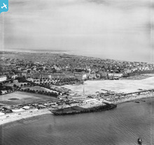
EAW025016 ENGLAND (1949). Clarence Pier, Southsea and environs, Old Portsmouth, from the west, 1949. This image has been produced from a print.

© Copyright OpenStreetMap contributors and licensed by the OpenStreetMap Foundation. 2026. Cartography is licensed as CC BY-SA.
Nearby Images (2)
EAW025016

EPW039678

Details
| Title | [EAW025016] Clarence Pier, Southsea and environs, Old Portsmouth, from the west, 1949. This image has been produced from a print. |
| Reference | EAW025016 |
| Date | 23-July-1949 |
| Link | |
| Place name | OLD PORTSMOUTH |
| Parish | |
| District | |
| Country | ENGLAND |
| Easting / Northing | 463409, 98866 |
| Longitude / Latitude | -1.1003973481232, 50.785328869141 |
| National Grid Reference | SZ634989 |
Pins

redmist |
Wednesday 14th of December 2022 10:54:08 PM | |
|
redmist |
Wednesday 14th of December 2022 09:00:02 PM | |
|
redmist |
Wednesday 14th of December 2022 08:57:49 PM | |
|
brianbeckett |
Tuesday 12th of May 2020 05:00:09 PM | |
|
jrussill |
Friday 12th of December 2014 04:56:34 PM |
User Comment Contributions
WW2 Searchlight |
jrussill |
Friday 12th of December 2014 04:57:23 PM |