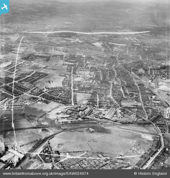
EAW024974 ENGLAND (1949). The F. H. Lloyd and Co James Bridge Steel Works and the surrounding area, Darlaston, from the north-east, 1949. This image was marked by Aerofilms Ltd for photo editing.
© Copyright OpenStreetMap contributors and licensed by the OpenStreetMap Foundation. 2025. Cartography is licensed as CC BY-SA.
Nearby Images (27)
Details
| Title | [EAW024974] The F. H. Lloyd and Co James Bridge Steel Works and the surrounding area, Darlaston, from the north-east, 1949. This image was marked by Aerofilms Ltd for photo editing. |
| Reference | EAW024974 |
| Date | 21-July-1949 |
| Link | |
| Place name | DARLASTON |
| Parish | |
| District | |
| Country | ENGLAND |
| Easting / Northing | 399154, 297050 |
| Longitude / Latitude | -2.0124839015899, 52.570913624656 |
| National Grid Reference | SO992971 |
Pins

KevTheBusDriver |
Sunday 28th of June 2015 07:40:03 PM |


![[EAW024974] The F. H. Lloyd and Co James Bridge Steel Works and the surrounding area, Darlaston, from the north-east, 1949. This image was marked by Aerofilms Ltd for photo editing.](http://britainfromabove.org.uk/sites/all/libraries/aerofilms-images/public/100x100/EAW/024/EAW024974.jpg)
![[EAW024982] The F. H. Lloyd and Co James Bridge Steel Works and the surrounding area, Darlaston, 1949. This image was marked by Aerofilms Ltd for photo editing.](http://britainfromabove.org.uk/sites/all/libraries/aerofilms-images/public/100x100/EAW/024/EAW024982.jpg)
![[EAW024976] The F. H. Lloyd and Co James Bridge Steel Works and the surrounding area, Darlaston, 1949. This image was marked by Aerofilms Ltd for photo editing.](http://britainfromabove.org.uk/sites/all/libraries/aerofilms-images/public/100x100/EAW/024/EAW024976.jpg)
![[EAW024983] The F. H. Lloyd and Co James Bridge Steel Works and the surrounding area, Darlaston, 1949. This image was marked by Aerofilms Ltd for photo editing.](http://britainfromabove.org.uk/sites/all/libraries/aerofilms-images/public/100x100/EAW/024/EAW024983.jpg)
![[EAW024972] The F. H. Lloyd and Co James Bridge Steel Works, Darlaston, 1949. This image was marked by Aerofilms Ltd for photo editing.](http://britainfromabove.org.uk/sites/all/libraries/aerofilms-images/public/100x100/EAW/024/EAW024972.jpg)
![[EAW024971] The F. H. Lloyd and Co James Bridge Steel Works, Darlaston, 1949. This image was marked by Aerofilms Ltd for photo editing.](http://britainfromabove.org.uk/sites/all/libraries/aerofilms-images/public/100x100/EAW/024/EAW024971.jpg)
![[EPW057526] F.H. Lloyd & Co James Bridge Steel Works, Darlaston, 1938](http://britainfromabove.org.uk/sites/all/libraries/aerofilms-images/public/100x100/EPW/057/EPW057526.jpg)
![[EAW042218] F. H. Lloyd & Co James Bridge Steel Works, Darlaston, 1952. This image has been produced from a damaged negative.](http://britainfromabove.org.uk/sites/all/libraries/aerofilms-images/public/100x100/EAW/042/EAW042218.jpg)
![[EAW000950] F. H. Lloyd & Co James Bridge Steel Works, Darlaston, 1946](http://britainfromabove.org.uk/sites/all/libraries/aerofilms-images/public/100x100/EAW/000/EAW000950.jpg)
![[EAW042208] F. H. Lloyd & Co James Bridge Steel Works, Darlaston, 1952. This image has been produced from a print.](http://britainfromabove.org.uk/sites/all/libraries/aerofilms-images/public/100x100/EAW/042/EAW042208.jpg)
![[EAW024975] The F. H. Lloyd and Co James Bridge Steel Works and the surrounding area, Darlaston, 1949. This image was marked by Aerofilms Ltd for photo editing.](http://britainfromabove.org.uk/sites/all/libraries/aerofilms-images/public/100x100/EAW/024/EAW024975.jpg)
![[EAW042206] F. H. Lloyd & Co James Bridge Steel Works, Darlaston, 1952. This image has been produced from a print marked by Aerofilms Ltd for photo editing.](http://britainfromabove.org.uk/sites/all/libraries/aerofilms-images/public/100x100/EAW/042/EAW042206.jpg)
![[EAW000951] F. H. Lloyd & Co James Bridge Steel Works, Darlaston, 1946](http://britainfromabove.org.uk/sites/all/libraries/aerofilms-images/public/100x100/EAW/000/EAW000951.jpg)
![[EPW057530] F.H. Lloyd & Co James Bridge Steel Works, Darlaston, 1938](http://britainfromabove.org.uk/sites/all/libraries/aerofilms-images/public/100x100/EPW/057/EPW057530.jpg)
![[EPW057524] F.H. Lloyd & Co James Bridge Steel Works, Darlaston, 1938](http://britainfromabove.org.uk/sites/all/libraries/aerofilms-images/public/100x100/EPW/057/EPW057524.jpg)
![[EAW000948] F. H. Lloyd & Co James Bridge Steel Works, Darlaston, 1946](http://britainfromabove.org.uk/sites/all/libraries/aerofilms-images/public/100x100/EAW/000/EAW000948.jpg)
![[EAW042214] F. H. Lloyd & Co James Bridge Steel Works, Darlaston, 1952. This image has been produced from a print marked by Aerofilms Ltd for photo editing.](http://britainfromabove.org.uk/sites/all/libraries/aerofilms-images/public/100x100/EAW/042/EAW042214.jpg)
![[EPW057528] F.H. Lloyd & Co James Bridge Steel Works, Darlaston, 1938](http://britainfromabove.org.uk/sites/all/libraries/aerofilms-images/public/100x100/EPW/057/EPW057528.jpg)
![[EPW057527] F.H. Lloyd & Co James Bridge Steel Works, Darlaston, 1938](http://britainfromabove.org.uk/sites/all/libraries/aerofilms-images/public/100x100/EPW/057/EPW057527.jpg)
![[EPW057529] F.H. Lloyd & Co James Bridge Steel Works, Darlaston, 1938](http://britainfromabove.org.uk/sites/all/libraries/aerofilms-images/public/100x100/EPW/057/EPW057529.jpg)
![[EAW000946] F. H. Lloyd & Co James Bridge Steel Works, Darlaston, 1946](http://britainfromabove.org.uk/sites/all/libraries/aerofilms-images/public/100x100/EAW/000/EAW000946.jpg)
![[EAW042209] F. H. Lloyd & Co James Bridge Steel Works, Darlaston, 1952. This image has been produced from a print marked by Aerofilms Ltd for photo editing.](http://britainfromabove.org.uk/sites/all/libraries/aerofilms-images/public/100x100/EAW/042/EAW042209.jpg)
![[EAW024978] The F. H. Lloyd and Co James Bridge Steel Works and the surrounding area, Darlaston, 1949. This image was marked by Aerofilms Ltd for photo editing.](http://britainfromabove.org.uk/sites/all/libraries/aerofilms-images/public/100x100/EAW/024/EAW024978.jpg)
![[EAW042219] F. H. Lloyd & Co James Bridge Steel Works, Darlaston, 1952. This image has been produced from a damaged negative.](http://britainfromabove.org.uk/sites/all/libraries/aerofilms-images/public/100x100/EAW/042/EAW042219.jpg)
![[EAW042212] F. H. Lloyd & Co James Bridge Steel Works, Darlaston, 1952. This image has been produced from a print marked by Aerofilms Ltd for photo editing.](http://britainfromabove.org.uk/sites/all/libraries/aerofilms-images/public/100x100/EAW/042/EAW042212.jpg)
![[EAW024973] The F. H. Lloyd and Co James Bridge Steel Works and the surrounding area, Darlaston, 1949. This image was marked by Aerofilms Ltd for photo editing.](http://britainfromabove.org.uk/sites/all/libraries/aerofilms-images/public/100x100/EAW/024/EAW024973.jpg)
![[EAW042217] F. H. Lloyd & Co James Bridge Steel Works, Darlaston, 1952. This image has been produced from a damaged negative.](http://britainfromabove.org.uk/sites/all/libraries/aerofilms-images/public/100x100/EAW/042/EAW042217.jpg)