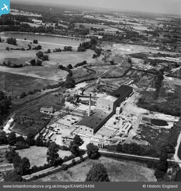
EAW024496 ENGLAND (1949). The Uxbridge Flint Brick Co Ltd Cowley Bridge Works on Iver Lane, Cowley, from the south-east, 1949
© Copyright OpenStreetMap contributors and licensed by the OpenStreetMap Foundation. 2026. Cartography is licensed as CC BY-SA.
Nearby Images (8)
Details
| Title | [EAW024496] The Uxbridge Flint Brick Co Ltd Cowley Bridge Works on Iver Lane, Cowley, from the south-east, 1949 |
| Reference | EAW024496 |
| Date | 9-July-1949 |
| Link | |
| Place name | COWLEY |
| Parish | |
| District | |
| Country | ENGLAND |
| Easting / Northing | 505002, 182314 |
| Longitude / Latitude | -0.4861188388545, 51.529480083504 |
| National Grid Reference | TQ050823 |
Pins

dave43 |
Friday 12th of August 2016 08:50:24 PM | |

dave43 |
Friday 12th of August 2016 08:49:13 PM | |

dave43 |
Friday 12th of August 2016 08:48:36 PM | |

dave43 |
Friday 12th of August 2016 08:45:52 PM | |

dave43 |
Friday 12th of August 2016 08:40:12 PM | |

Brick Collector |
Tuesday 17th of March 2015 09:15:52 PM | |
I think it ran out to the gravel pit, gradually became quite large and in 1970's had power boat racing on pit, they used to watch from the high rise flats in Chiltern View Rd Rabbs Mill etc, filled in when M25 went thru of course Flint brick was really Cape Universal ASBESTOS! |

dave43 |
Friday 12th of August 2016 08:44:05 PM |


![[EAW024496] The Uxbridge Flint Brick Co Ltd Cowley Bridge Works on Iver Lane, Cowley, from the south-east, 1949](http://britainfromabove.org.uk/sites/all/libraries/aerofilms-images/public/100x100/EAW/024/EAW024496.jpg)
![[EAW024500] The Uxbridge Flint Brick Co Ltd Cowley Bridge Works on Iver Lane, Cowley, from the south, 1949. This image was marked by Aerofilms Ltd for photo editing.](http://britainfromabove.org.uk/sites/all/libraries/aerofilms-images/public/100x100/EAW/024/EAW024500.jpg)
![[EAW024495] The Uxbridge Flint Brick Co Ltd Cowley Bridge Works on Iver Lane, Cowley, from the north-east, 1949](http://britainfromabove.org.uk/sites/all/libraries/aerofilms-images/public/100x100/EAW/024/EAW024495.jpg)
![[EAW024497] The Uxbridge Flint Brick Co Ltd Cowley Bridge Works on Iver Lane, Cowley, from the south-west, 1949](http://britainfromabove.org.uk/sites/all/libraries/aerofilms-images/public/100x100/EAW/024/EAW024497.jpg)
![[EAW024501] The Uxbridge Flint Brick Co Ltd Cowley Bridge Works on Iver Lane, Cowley, from the south-west, 1949. This image was marked by Aerofilms Ltd for photo editing.](http://britainfromabove.org.uk/sites/all/libraries/aerofilms-images/public/100x100/EAW/024/EAW024501.jpg)
![[EAW024502] The Uxbridge Flint Brick Co Ltd Cowley Bridge Works on Iver Lane, Cowley, from the west, 1949](http://britainfromabove.org.uk/sites/all/libraries/aerofilms-images/public/100x100/EAW/024/EAW024502.jpg)
![[EAW024499] The Uxbridge Flint Brick Co Ltd Cowley Bridge Works on Iver Lane, Cowley, from the east, 1949](http://britainfromabove.org.uk/sites/all/libraries/aerofilms-images/public/100x100/EAW/024/EAW024499.jpg)
![[EAW024498] The Uxbridge Flint Brick Co Ltd Cowley Bridge Works on Iver Lane, Cowley, from the north-west, 1949](http://britainfromabove.org.uk/sites/all/libraries/aerofilms-images/public/100x100/EAW/024/EAW024498.jpg)