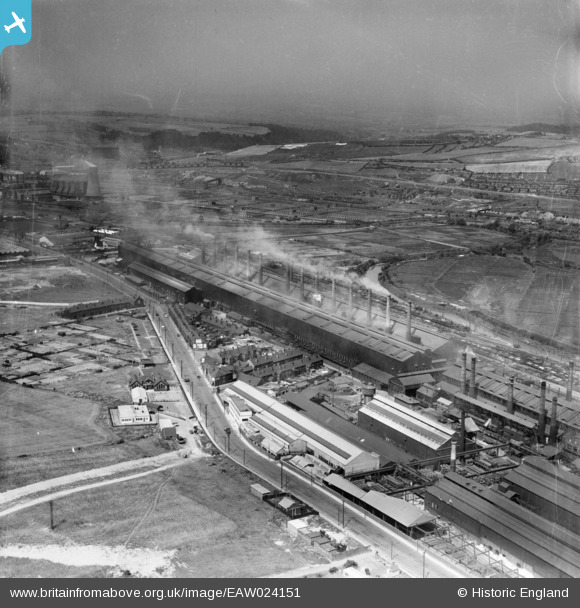
EAW024151 ENGLAND (1949). The Steel, Peech and Tozer Templeborough Steel Works and Rolling Mills, Templeborough, from the south-east, 1949
© Copyright OpenStreetMap contributors and licensed by the OpenStreetMap Foundation. 2026. Cartography is licensed as CC BY-SA.
Nearby Images (9)
Details
| Title | [EAW024151] The Steel, Peech and Tozer Templeborough Steel Works and Rolling Mills, Templeborough, from the south-east, 1949 |
| Reference | EAW024151 |
| Date | 22-June-1949 |
| Link | |
| Place name | TEMPLEBOROUGH |
| Parish | |
| District | |
| Country | ENGLAND |
| Easting / Northing | 441111, 391428 |
| Longitude / Latitude | -1.381361334028, 53.417791603157 |
| National Grid Reference | SK411914 |
Pins
MandM |
Wednesday 12th of November 2014 06:00:21 PM | |
I always knew it as 'Blackburn Meadows' power station? |

Holmes Junction |
Thursday 22nd of January 2015 08:15:09 PM |


![[EAW024151] The Steel, Peech and Tozer Templeborough Steel Works and Rolling Mills, Templeborough, from the south-east, 1949](http://britainfromabove.org.uk/sites/all/libraries/aerofilms-images/public/100x100/EAW/024/EAW024151.jpg)
![[EPW015447] Templeborough Steel Works, Templeborough, 1926](http://britainfromabove.org.uk/sites/all/libraries/aerofilms-images/public/100x100/EPW/015/EPW015447.jpg)
![[EPW041701] The Templeborough Steel Works alongside the River Don, Rotherham, 1933](http://britainfromabove.org.uk/sites/all/libraries/aerofilms-images/public/100x100/EPW/041/EPW041701.jpg)
![[EPW041704] The Templeborough Steel Works alongside the River Don, Rotherham, 1933](http://britainfromabove.org.uk/sites/all/libraries/aerofilms-images/public/100x100/EPW/041/EPW041704.jpg)
![[EAW030483] The Steel, Peech and Tozer Templeborough Steel Works and environs, Templeborough, 1950](http://britainfromabove.org.uk/sites/all/libraries/aerofilms-images/public/100x100/EAW/030/EAW030483.jpg)
![[EPW041702] The Templeborough Steel Works and environs, Rotherham, 1933](http://britainfromabove.org.uk/sites/all/libraries/aerofilms-images/public/100x100/EPW/041/EPW041702.jpg)
![[EAW029394] The Steel, Peech and Tozer Templeborough Steel Works, Ickles, 1950](http://britainfromabove.org.uk/sites/all/libraries/aerofilms-images/public/100x100/EAW/029/EAW029394.jpg)
![[EPW041706] The Templeborough Steel Works alongside the River Don, Rotherham, 1933](http://britainfromabove.org.uk/sites/all/libraries/aerofilms-images/public/100x100/EPW/041/EPW041706.jpg)
![[EAW030484] The Steel, Peech and Tozer Templeborough Steel Works and environs, Templeborough, 1950](http://britainfromabove.org.uk/sites/all/libraries/aerofilms-images/public/100x100/EAW/030/EAW030484.jpg)