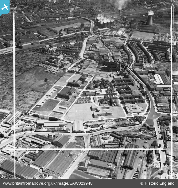
EAW023948 ENGLAND (1949). The Central Middlesex Hospital on Acton Lane, Lower Place, 1949. This image was marked by Aerofilms Ltd for photo editing.
© Copyright OpenStreetMap contributors and licensed by the OpenStreetMap Foundation. 2026. Cartography is licensed as CC BY-SA.
Nearby Images (9)
Details
| Title | [EAW023948] The Central Middlesex Hospital on Acton Lane, Lower Place, 1949. This image was marked by Aerofilms Ltd for photo editing. |
| Reference | EAW023948 |
| Date | 23-June-1949 |
| Link | |
| Place name | LOWER PLACE |
| Parish | |
| District | |
| Country | ENGLAND |
| Easting / Northing | 520232, 182862 |
| Longitude / Latitude | -0.26645231994991, 51.531367637197 |
| National Grid Reference | TQ202829 |
Pins

Graham Honey |
Friday 5th of July 2024 10:29:25 PM |


![[EAW023948] The Central Middlesex Hospital on Acton Lane, Lower Place, 1949. This image was marked by Aerofilms Ltd for photo editing.](http://britainfromabove.org.uk/sites/all/libraries/aerofilms-images/public/100x100/EAW/023/EAW023948.jpg)
![[EAW023951] The Central Middlesex Hospital on Acton Lane, Lower Place, 1949. This image was marked by Aerofilms Ltd for photo editing.](http://britainfromabove.org.uk/sites/all/libraries/aerofilms-images/public/100x100/EAW/023/EAW023951.jpg)
![[EAW023956] The Central Middlesex Hospital on Acton Lane, Lower Place, 1949. This image was marked by Aerofilms Ltd for photo editing.](http://britainfromabove.org.uk/sites/all/libraries/aerofilms-images/public/100x100/EAW/023/EAW023956.jpg)
![[EAW023949] The Central Middlesex Hospital on Acton Lane, Lower Place, 1949. This image was marked by Aerofilms Ltd for photo editing.](http://britainfromabove.org.uk/sites/all/libraries/aerofilms-images/public/100x100/EAW/023/EAW023949.jpg)
![[EAW023953] The Central Middlesex Hospital on Acton Lane, Lower Place, 1949. This image was marked by Aerofilms Ltd for photo editing.](http://britainfromabove.org.uk/sites/all/libraries/aerofilms-images/public/100x100/EAW/023/EAW023953.jpg)
![[EAW023950] The Central Middlesex Hospital on Acton Lane, Lower Place, 1949. This image was marked by Aerofilms Ltd for photo editing.](http://britainfromabove.org.uk/sites/all/libraries/aerofilms-images/public/100x100/EAW/023/EAW023950.jpg)
![[EAW023952] The Central Middlesex Hospital on Acton Lane, Lower Place, 1949. This image was marked by Aerofilms Ltd for photo editing.](http://britainfromabove.org.uk/sites/all/libraries/aerofilms-images/public/100x100/EAW/023/EAW023952.jpg)
![[EAW023954] The Central Middlesex Hospital on Acton Lane, Lower Place, 1949. This image was marked by Aerofilms Ltd for photo editing.](http://britainfromabove.org.uk/sites/all/libraries/aerofilms-images/public/100x100/EAW/023/EAW023954.jpg)
![[EAW023955] The Central Middlesex Hospital on Acton Lane, Lower Place, 1949. This image was marked by Aerofilms Ltd for photo editing.](http://britainfromabove.org.uk/sites/all/libraries/aerofilms-images/public/100x100/EAW/023/EAW023955.jpg)
