
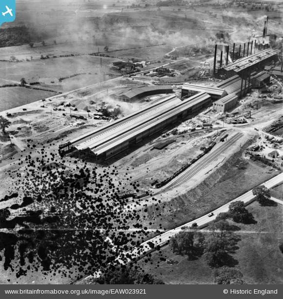
EAW023921 ENGLAND (1949). The John Lysaght Normanby Park Steel Works, Scunthorpe, 1949. This image has been produced from a damaged negative.
© Copyright OpenStreetMap contributors and licensed by the OpenStreetMap Foundation. 2026. Cartography is licensed as CC BY-SA.
Nearby Images (48)
EAW038754

EAW009412

EAW038756

EAW031168

EAW038777

EAW013492

EAW027163

EAW034810

EAW038749

EAW013825

EAW038759

EAW038764

EAW023922

EAW038758

EAW021127

EAW038755

EAW038753

EAW023920

EAW021141
, Scunthorpe, 1949. This image has been produced from a damaged negative.")
EAW013491

EAW021130

EAW027171

EAW034802

EAW009413

EAW013496

EAW021129

EAW031169

EAW028577

EAW034808

EAW013495

EAW013494

EAW019677

EAW031176

EAW027167

EAW038767

EAW034809

EAW034807

EAW031180

EAW009627

EAW016659

EAW041829

EAW028576

EAW027168

EAW034820

EAW041838

EAW009414

EAW034798

EAW041831

Details
| Title | [EAW023921] The John Lysaght Normanby Park Steel Works, Scunthorpe, 1949. This image has been produced from a damaged negative. |
| Reference | EAW023921 |
| Date | 20-June-1949 |
| Link | |
| Place name | SCUNTHORPE |
| Parish | |
| District | |
| Country | ENGLAND |
| Easting / Northing | 489062, 413147 |
| Longitude / Latitude | -0.6537803054899, 53.60706362188 |
| National Grid Reference | SE891131 |
Pins

redmist |
Friday 1st of February 2019 08:41:18 PM |