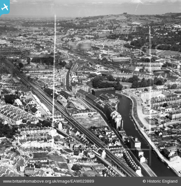
EAW023889 ENGLAND (1949). The Newark Works, River Avon and environs, Bath, from the south-east, 1949. This image has been produced from a print marked by Aerofilms Ltd for photo editing.
© Copyright OpenStreetMap contributors and licensed by the OpenStreetMap Foundation. 2026. Cartography is licensed as CC BY-SA.
Nearby Images (15)
Details
| Title | [EAW023889] The Newark Works, River Avon and environs, Bath, from the south-east, 1949. This image has been produced from a print marked by Aerofilms Ltd for photo editing. |
| Reference | EAW023889 |
| Date | 14-June-1949 |
| Link | |
| Place name | BATH |
| Parish | |
| District | |
| Country | ENGLAND |
| Easting / Northing | 374756, 164363 |
| Longitude / Latitude | -2.3627415489496, 51.377260479877 |
| National Grid Reference | ST748644 |


![[EAW023889] The Newark Works, River Avon and environs, Bath, from the south-east, 1949. This image has been produced from a print marked by Aerofilms Ltd for photo editing.](http://britainfromabove.org.uk/sites/all/libraries/aerofilms-images/public/100x100/EAW/023/EAW023889.jpg)
![[EAW002944] The Newark Works, Lower Bristol Road and environs, Bath, from the south-east, 1946](http://britainfromabove.org.uk/sites/all/libraries/aerofilms-images/public/100x100/EAW/002/EAW002944.jpg)
![[EPW001944] General view over Kingsmead, Bath, 1920](http://britainfromabove.org.uk/sites/all/libraries/aerofilms-images/public/100x100/EPW/001/EPW001944.jpg)
![[EAW023886] The Newark Works, River Avon and environs, Bath, from the south-east, 1949. This image has been produced from a print marked by Aerofilms Ltd for photo editing.](http://britainfromabove.org.uk/sites/all/libraries/aerofilms-images/public/100x100/EAW/023/EAW023886.jpg)
![[EAW023888] The Newark Works, River Avon and environs, Bath, from the south-east, 1949. This image has been produced from a print marked by Aerofilms Ltd for photo editing.](http://britainfromabove.org.uk/sites/all/libraries/aerofilms-images/public/100x100/EAW/023/EAW023888.jpg)
![[EAW002945] The Newark Works, Lower Bristol Road and environs, Bath, from the east, 1946](http://britainfromabove.org.uk/sites/all/libraries/aerofilms-images/public/100x100/EAW/002/EAW002945.jpg)
![[EAW026457] The city centre, Bath, from the west, 1949](http://britainfromabove.org.uk/sites/all/libraries/aerofilms-images/public/100x100/EAW/026/EAW026457.jpg)
![[EAW002940] The Newark Works and Lower Bristol Road, Bath, 1946](http://britainfromabove.org.uk/sites/all/libraries/aerofilms-images/public/100x100/EAW/002/EAW002940.jpg)
![[EAW002941] The Newark Works and environs, Bath, 1946](http://britainfromabove.org.uk/sites/all/libraries/aerofilms-images/public/100x100/EAW/002/EAW002941.jpg)
![[EAW026458] The city centre, Bath, from the south, 1949](http://britainfromabove.org.uk/sites/all/libraries/aerofilms-images/public/100x100/EAW/026/EAW026458.jpg)
![[EAW023887] The Forum, Newark Works, River Avon and environs, Bath, from the east, 1949. This image has been produced from a print marked by Aerofilms Ltd for photo editing.](http://britainfromabove.org.uk/sites/all/libraries/aerofilms-images/public/100x100/EAW/023/EAW023887.jpg)
![[EAW002942] The Newark Works and the River Avon, Bath, 1946](http://britainfromabove.org.uk/sites/all/libraries/aerofilms-images/public/100x100/EAW/002/EAW002942.jpg)
![[EAW002939] The Newark Works and the River Avon, Bath, 1946](http://britainfromabove.org.uk/sites/all/libraries/aerofilms-images/public/100x100/EAW/002/EAW002939.jpg)
![[EPW001169] View over central Bath from Alexandra Park, Bath, 1920](http://britainfromabove.org.uk/sites/all/libraries/aerofilms-images/public/100x100/EPW/001/EPW001169.jpg)
![[EPR000130] Broad Quay and the city centre, Bath, 1934](http://britainfromabove.org.uk/sites/all/libraries/aerofilms-images/public/100x100/EPR/000/EPR000130.jpg)
