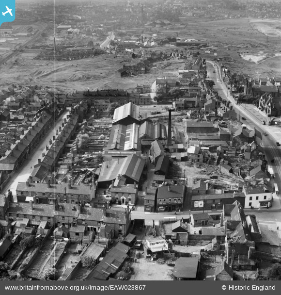
EAW023867 ENGLAND (1949). The Hilltop Foundry Co Ltd Hill Top Foundry, Hill Top, 1949. This image was marked by Aerofilms Ltd for photo editing.
© Copyright OpenStreetMap contributors and licensed by the OpenStreetMap Foundation. 2026. Cartography is licensed as CC BY-SA.
Details
| Title | [EAW023867] The Hilltop Foundry Co Ltd Hill Top Foundry, Hill Top, 1949. This image was marked by Aerofilms Ltd for photo editing. |
| Reference | EAW023867 |
| Date | 15-June-1949 |
| Link | |
| Place name | HILL TOP |
| Parish | |
| District | |
| Country | ENGLAND |
| Easting / Northing | 399225, 293420 |
| Longitude / Latitude | -2.0114277161127, 52.538276785709 |
| National Grid Reference | SO992934 |
Pins

DaveT |
Monday 24th of February 2014 04:44:54 PM | |

DaveT |
Friday 20th of December 2013 08:55:32 PM | |

DaveT |
Friday 20th of December 2013 08:54:57 PM | |

DaveT |
Friday 20th of December 2013 05:32:58 PM | |
Was this bridge still there in the late 1950s, I can remember the canal finishing a lot further to railway bridge then. But memory can play tricks, I was 13 in 1960 and lived at my grans house in Queen Street for a year, marvellous stumbling onto this site as there's no pictures of Queen Street anywhere to my knowledge, Prices' chippie was the best for miles, 4penworth of chips and a bottle of dandelion and burdock, the best supper in the world m8. apalanporter@gmail.com to reply. |

02ba |
Friday 13th of October 2017 06:16:26 PM |

Catso |
Wednesday 18th of December 2013 03:20:18 PM | |

Catso |
Wednesday 18th of December 2013 03:19:40 PM |


![[EAW023867] The Hilltop Foundry Co Ltd Hill Top Foundry, Hill Top, 1949. This image was marked by Aerofilms Ltd for photo editing.](http://britainfromabove.org.uk/sites/all/libraries/aerofilms-images/public/100x100/EAW/023/EAW023867.jpg)
![[EAW023869] The Hilltop Foundry Co Ltd Hill Top Foundry, Hill Top, 1949. This image was marked by Aerofilms Ltd for photo editing.](http://britainfromabove.org.uk/sites/all/libraries/aerofilms-images/public/100x100/EAW/023/EAW023869.jpg)
![[EAW023868] The Hilltop Foundry Co Ltd Hill Top Foundry, Hill Top, 1949. This image was marked by Aerofilms Ltd for photo editing.](http://britainfromabove.org.uk/sites/all/libraries/aerofilms-images/public/100x100/EAW/023/EAW023868.jpg)