
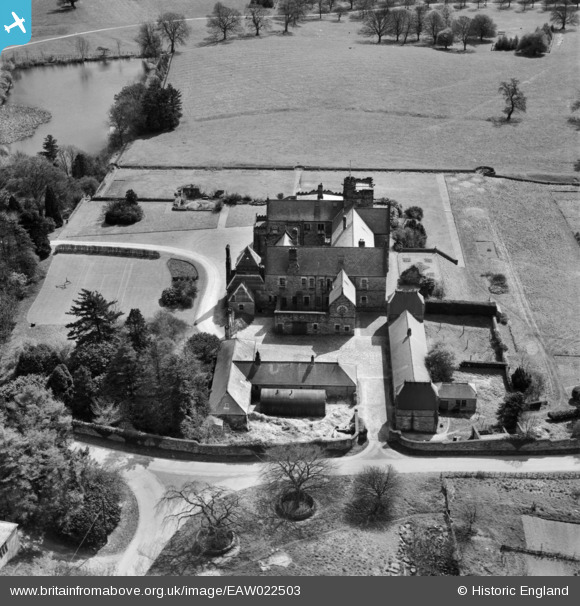
EAW022503 ENGLAND (1949). Upsall Castle, Upsall, 1949
© Copyright OpenStreetMap contributors and licensed by the OpenStreetMap Foundation. 2026. Cartography is licensed as CC BY-SA.
Nearby Images (4)
EAW022503

EAW022506

EAW022504

EAW022505

Details
| Title | [EAW022503] Upsall Castle, Upsall, 1949 |
| Reference | EAW022503 |
| Date | 20-April-1949 |
| Link | |
| Place name | UPSALL |
| Parish | UPSALL |
| District | |
| Country | ENGLAND |
| Easting / Northing | 445359, 487006 |
| Longitude / Latitude | -1.3033220197236, 54.276526038813 |
| National Grid Reference | SE454870 |
Pins

totoro |
Saturday 7th of June 2014 05:45:50 PM | |
|
totoro |
Saturday 7th of June 2014 05:45:33 PM |
User Comment Contributions
UPSALL CASTLE (occaisionally mentioned as Upfall) The old gatehouse and the remains of the castle walls are listed. It looks modern - and it is, relatively. A castle of 1327 was probably destroyed in the Civil War and a manor house took its place. The manor house was rebuilt in the 19th Century. This manor house was destroyed by fire in 1911 (or 1918?) and then another was built about 1922- which we see now. The estate has been in the Turton family since 1768. The Upsall beef cattle herd of Beef Polled Shorthorn cattle is the oldest in England having been established in 1909. The village of Upsall has a population below 100. Not too far away is Kirby Knowle Castle- Also known as, or recorded in historical documents as Kirkby Knowle; Newbygill; New Building) |
totoro |
Saturday 7th of June 2014 05:02:59 PM |