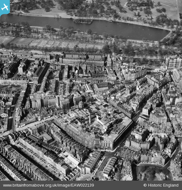
EAW022139 ENGLAND (1949). Hans Road, Brompton Road and The Serpentine, Knightsbridge, 1949
© Copyright OpenStreetMap contributors and licensed by the OpenStreetMap Foundation. 2026. Cartography is licensed as CC BY-SA.
Nearby Images (7)
Details
| Title | [EAW022139] Hans Road, Brompton Road and The Serpentine, Knightsbridge, 1949 |
| Reference | EAW022139 |
| Date | 14-April-1949 |
| Link | |
| Place name | KNIGHTSBRIDGE |
| Parish | |
| District | |
| Country | ENGLAND |
| Easting / Northing | 527582, 179542 |
| Longitude / Latitude | -0.16173637927692, 51.499914712111 |
| National Grid Reference | TQ276795 |
Pins

David960 |
Saturday 19th of March 2016 10:20:19 AM | |

Class31 |
Friday 16th of May 2014 04:05:59 PM | |

brian |
Monday 12th of May 2014 01:20:38 AM | |
No, Harvey Nichols |

David960 |
Saturday 19th of March 2016 10:19:53 AM |

Alan McFaden |
Saturday 11th of January 2014 08:00:46 PM | |

Alan McFaden |
Saturday 11th of January 2014 08:00:21 PM |


![[EAW022139] Hans Road, Brompton Road and The Serpentine, Knightsbridge, 1949](http://britainfromabove.org.uk/sites/all/libraries/aerofilms-images/public/100x100/EAW/022/EAW022139.jpg)
![[EAW021419] Brompton Road looking towards Hyde Park, Knightsbridge, 1949. This image has been produced from a print.](http://britainfromabove.org.uk/sites/all/libraries/aerofilms-images/public/100x100/EAW/021/EAW021419.jpg)
![[EAW021420] Harrods and environs, Brompton, 1949. This image has been produced from a print.](http://britainfromabove.org.uk/sites/all/libraries/aerofilms-images/public/100x100/EAW/021/EAW021420.jpg)
![[EPW030076] The R101 airship on its first test flight over Hyde Park, Westminster, 1929](http://britainfromabove.org.uk/sites/all/libraries/aerofilms-images/public/100x100/EPW/030/EPW030076.jpg)
![[EAW022138] Brompton Road and Hyde Park, Knightsbridge, 1949](http://britainfromabove.org.uk/sites/all/libraries/aerofilms-images/public/100x100/EAW/022/EAW022138.jpg)
![[EAW000555] Hans Place, Basil Street, Hyde Park and environs, Knightsbridge, 1946](http://britainfromabove.org.uk/sites/all/libraries/aerofilms-images/public/100x100/EAW/000/EAW000555.jpg)
![[EPW016658] Montpelier Square, Knightsbridge, 1926](http://britainfromabove.org.uk/sites/all/libraries/aerofilms-images/public/100x100/EPW/016/EPW016658.jpg)

