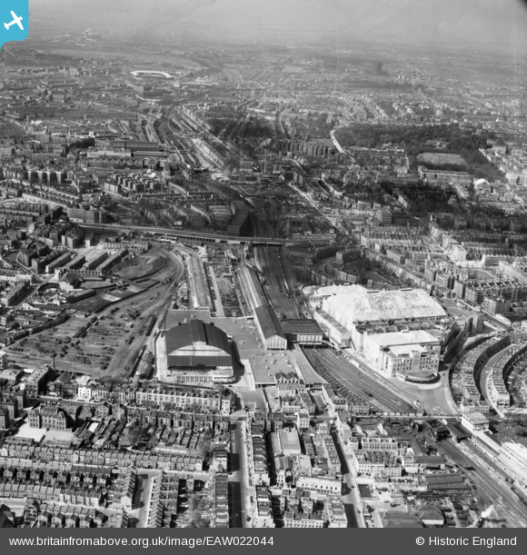
EAW022044 ENGLAND (1949). Earls Court Exhibition Centre, Earl's Court, from the south-east, 1949
© Copyright OpenStreetMap contributors and licensed by the OpenStreetMap Foundation. 2026. Cartography is licensed as CC BY-SA.
Nearby Images (48)
Details
| Title | [EAW022044] Earls Court Exhibition Centre, Earl's Court, from the south-east, 1949 |
| Reference | EAW022044 |
| Date | 14-April-1949 |
| Link | |
| Place name | EARL'S COURT |
| Parish | |
| District | |
| Country | ENGLAND |
| Easting / Northing | 525201, 178019 |
| Longitude / Latitude | -0.19656492809104, 51.486758412506 |
| National Grid Reference | TQ252780 |
Pins

brianbeckett |
Friday 24th of July 2020 04:43:01 PM | |

brianbeckett |
Friday 24th of July 2020 04:40:23 PM | |

brianbeckett |
Friday 24th of July 2020 04:35:48 PM | |

cptpies |
Friday 19th of June 2020 09:11:54 AM | |

Leslie B |
Sunday 1st of October 2017 10:56:32 PM | |

Sparky |
Saturday 26th of August 2017 05:37:11 PM | |

Sparky |
Saturday 26th of August 2017 05:36:53 PM | |

Class31 |
Sunday 26th of October 2014 07:16:36 PM | |

Class31 |
Sunday 26th of October 2014 07:15:07 PM | |

Class31 |
Sunday 26th of October 2014 07:13:57 PM | |

Class31 |
Sunday 26th of October 2014 07:12:09 PM | |

Class31 |
Sunday 26th of October 2014 07:11:25 PM | |

Class31 |
Sunday 26th of October 2014 07:10:21 PM |


![[EAW022044] Earls Court Exhibition Centre, Earl's Court, from the south-east, 1949](http://britainfromabove.org.uk/sites/all/libraries/aerofilms-images/public/100x100/EAW/022/EAW022044.jpg)
![[EPW055901] Empress Hall and Earls Court Exhibition Centre, Fulham, 1937](http://britainfromabove.org.uk/sites/all/libraries/aerofilms-images/public/100x100/EPW/055/EPW055901.jpg)
![[EPW055910] Empress Hall, Fulham, 1937](http://britainfromabove.org.uk/sites/all/libraries/aerofilms-images/public/100x100/EPW/055/EPW055910.jpg)
![[EPW055904] Empress Hall, Fulham, 1937](http://britainfromabove.org.uk/sites/all/libraries/aerofilms-images/public/100x100/EPW/055/EPW055904.jpg)
![[EPW055900] Empress Hall, Fulham, 1937](http://britainfromabove.org.uk/sites/all/libraries/aerofilms-images/public/100x100/EPW/055/EPW055900.jpg)
![[EPW051555] The Empress Hall and the Earls Court Exhibition Centre under construction, Fulham, 1936](http://britainfromabove.org.uk/sites/all/libraries/aerofilms-images/public/100x100/EPW/051/EPW051555.jpg)
![[EPW054657] The Empress Hall, Fulham, 1937](http://britainfromabove.org.uk/sites/all/libraries/aerofilms-images/public/100x100/EPW/054/EPW054657.jpg)
![[EPW051554] The Earls Court Exhibition Centre under construction, Earl's Court, 1936](http://britainfromabove.org.uk/sites/all/libraries/aerofilms-images/public/100x100/EPW/051/EPW051554.jpg)
![[EPW051556] The Empress Hall and the Earls Court Exhibition Centre under construction, Fulham, 1936](http://britainfromabove.org.uk/sites/all/libraries/aerofilms-images/public/100x100/EPW/051/EPW051556.jpg)
![[EPW052787] Earls Court Exhibition Centre under construction, Earl's Court, 1937](http://britainfromabove.org.uk/sites/all/libraries/aerofilms-images/public/100x100/EPW/052/EPW052787.jpg)
![[EPW024262] Earl's Court Exhibition Grounds and Lillie Bridge Depot, Earl's Court, 1928](http://britainfromabove.org.uk/sites/all/libraries/aerofilms-images/public/100x100/EPW/024/EPW024262.jpg)
![[EAW000107] Earls Court Exhibition Centre, Earl's Court, 1946](http://britainfromabove.org.uk/sites/all/libraries/aerofilms-images/public/100x100/EAW/000/EAW000107.jpg)
![[EPW051916] The Earls Court Exhibition Centre under construction, Earl's Court, 1936](http://britainfromabove.org.uk/sites/all/libraries/aerofilms-images/public/100x100/EPW/051/EPW051916.jpg)
![[EPW052533] Earls Court Exhibition Centre under construction, Earl's Court, 1937. This image has been produced from a print.](http://britainfromabove.org.uk/sites/all/libraries/aerofilms-images/public/100x100/EPW/052/EPW052533.jpg)
![[EPW059934] The Earls Court Exhibition Centre, Empress Theatre and surrounding residential areas, Earl's Court, 1938](http://britainfromabove.org.uk/sites/all/libraries/aerofilms-images/public/100x100/EPW/059/EPW059934.jpg)
![[EPW055290] Earls Court Exhibition Centre, Earl's Court, 1937](http://britainfromabove.org.uk/sites/all/libraries/aerofilms-images/public/100x100/EPW/055/EPW055290.jpg)
![[EPW024261] Earl's Court Exhibition Grounds and Earl's Court Railway Station, Earl's Court, 1928](http://britainfromabove.org.uk/sites/all/libraries/aerofilms-images/public/100x100/EPW/024/EPW024261.jpg)
![[EPW052251] The Earls Court Exhibition Centre under construction, Earl's Court, 1936. This image has been produced from a print.](http://britainfromabove.org.uk/sites/all/libraries/aerofilms-images/public/100x100/EPW/052/EPW052251.jpg)
![[EPW051912] The Earls Court Exhibition Centre under construction, Earl's Court, 1936](http://britainfromabove.org.uk/sites/all/libraries/aerofilms-images/public/100x100/EPW/051/EPW051912.jpg)
![[EPW053636] The Earls Court Exhibition Centre (Earls Court One) under construction, Earl's Court, 1937](http://britainfromabove.org.uk/sites/all/libraries/aerofilms-images/public/100x100/EPW/053/EPW053636.jpg)
![[EPW053628] The Earls Court Exhibition Centre (Earls Court One) under construction, Earl's Court, 1937](http://britainfromabove.org.uk/sites/all/libraries/aerofilms-images/public/100x100/EPW/053/EPW053628.jpg)
![[EPW053626] The Earls Court Exhibition Centre (Earls Court One) under construction, Earl's Court, 1937](http://britainfromabove.org.uk/sites/all/libraries/aerofilms-images/public/100x100/EPW/053/EPW053626.jpg)
![[EPW055902] Empress Hall and Earls Court Exhibition Centre, Earl's Court, 1937](http://britainfromabove.org.uk/sites/all/libraries/aerofilms-images/public/100x100/EPW/055/EPW055902.jpg)
![[EPW052932] The Earls Court Exhibition Centre (Earls Court One) under construction, Earl's Court, 1937](http://britainfromabove.org.uk/sites/all/libraries/aerofilms-images/public/100x100/EPW/052/EPW052932.jpg)
![[EPW054655] The newly completed Earls Court Exhibition Centre, Earl's Court, 1937](http://britainfromabove.org.uk/sites/all/libraries/aerofilms-images/public/100x100/EPW/054/EPW054655.jpg)
![[EPW052783] Earls Court Exhibition Centre under construction, Earl's Court, 1937](http://britainfromabove.org.uk/sites/all/libraries/aerofilms-images/public/100x100/EPW/052/EPW052783.jpg)
![[EPW055909] Earls Court Exhibition Centre, Earl's Court, 1937](http://britainfromabove.org.uk/sites/all/libraries/aerofilms-images/public/100x100/EPW/055/EPW055909.jpg)
![[EPW052936] The Earls Court Exhibition Centre (Earls Court One) under construction, Earl's Court, 1937](http://britainfromabove.org.uk/sites/all/libraries/aerofilms-images/public/100x100/EPW/052/EPW052936.jpg)
![[EPW052931] The Earls Court Exhibition Centre (Earls Court One) under construction, Earl's Court, 1937](http://britainfromabove.org.uk/sites/all/libraries/aerofilms-images/public/100x100/EPW/052/EPW052931.jpg)
![[EPW051911] The Earls Court Exhibition Centre under construction, Earl's Court, 1936](http://britainfromabove.org.uk/sites/all/libraries/aerofilms-images/public/100x100/EPW/051/EPW051911.jpg)
![[EPW051910] The Earl's Court Exhibition Centre under construction, Earl's Court, 1936](http://britainfromabove.org.uk/sites/all/libraries/aerofilms-images/public/100x100/EPW/051/EPW051910.jpg)
![[EPW051913] The Earls Court Exhibition Centre under construction, Earl's Court, 1936](http://britainfromabove.org.uk/sites/all/libraries/aerofilms-images/public/100x100/EPW/051/EPW051913.jpg)
![[EPW053629] The Earls Court Exhibition Centre (Earls Court One) under construction, Earl's Court, 1937](http://britainfromabove.org.uk/sites/all/libraries/aerofilms-images/public/100x100/EPW/053/EPW053629.jpg)
![[EPW052253] The Earl's Court Exhibition Centre under construction, Earl's Court, 1936. This image was produced from a damaged negative.](http://britainfromabove.org.uk/sites/all/libraries/aerofilms-images/public/100x100/EPW/052/EPW052253.jpg)
![[EPW051915] The Earls Court Exhibition Centre under construction, Earl's Court, 1936](http://britainfromabove.org.uk/sites/all/libraries/aerofilms-images/public/100x100/EPW/051/EPW051915.jpg)
![[EPW052789] Earls Court Exhibition Centre under construction, Earl's Court, 1937](http://britainfromabove.org.uk/sites/all/libraries/aerofilms-images/public/100x100/EPW/052/EPW052789.jpg)
![[EPW053627] The Earls Court Exhibition Centre (Earls Court One) under construction, Earl's Court, 1937](http://britainfromabove.org.uk/sites/all/libraries/aerofilms-images/public/100x100/EPW/053/EPW053627.jpg)
![[EPW052944] The Earls Court Exhibition Centre (Earls Court One) under construction, Earl's Court, 1937](http://britainfromabove.org.uk/sites/all/libraries/aerofilms-images/public/100x100/EPW/052/EPW052944.jpg)
![[EPW055905] Earls Court Exhibition Centre, Earl's Court, 1937](http://britainfromabove.org.uk/sites/all/libraries/aerofilms-images/public/100x100/EPW/055/EPW055905.jpg)
![[EPW052791] Earls Court Exhibition Centre under construction, Earl's Court, 1937](http://britainfromabove.org.uk/sites/all/libraries/aerofilms-images/public/100x100/EPW/052/EPW052791.jpg)
![[EAW015275] Car parking around the Empress Hall and Earls Court Exhibition Centre for the British Industries Fair, Fulham, 1948](http://britainfromabove.org.uk/sites/all/libraries/aerofilms-images/public/100x100/EAW/015/EAW015275.jpg)
![[EPW052395] The Earls Court Exhibition Centre (Earls Court One) under construction, Earl's Court, 1937. This image has been produced from a copy-negative.](http://britainfromabove.org.uk/sites/all/libraries/aerofilms-images/public/100x100/EPW/052/EPW052395.jpg)
![[EPW054652] The newly completed Earls Court Exhibition Centre and the Empress Hall, Earl's Court, 1937](http://britainfromabove.org.uk/sites/all/libraries/aerofilms-images/public/100x100/EPW/054/EPW054652.jpg)
![[EAW018710] The Earls Court Exhibition Centre, Ear's Court, 1948. This image has been produced from a print.](http://britainfromabove.org.uk/sites/all/libraries/aerofilms-images/public/100x100/EAW/018/EAW018710.jpg)
![[EPW060954] Earls Court Exhibition Centre, Earl's Court, 1939](http://britainfromabove.org.uk/sites/all/libraries/aerofilms-images/public/100x100/EPW/060/EPW060954.jpg)
![[EPW052933] The Earls Court Exhibition Centre (Earls Court One) under construction, Earl's Court, 1937](http://britainfromabove.org.uk/sites/all/libraries/aerofilms-images/public/100x100/EPW/052/EPW052933.jpg)
![[EPW053634] The Earls Court Exhibition Centre (Earls Court One) under construction, Earl's Court, 1937](http://britainfromabove.org.uk/sites/all/libraries/aerofilms-images/public/100x100/EPW/053/EPW053634.jpg)
![[EPW053631] The Earls Court Exhibition Centre (Earls Court One) under construction, Earl's Court, 1937](http://britainfromabove.org.uk/sites/all/libraries/aerofilms-images/public/100x100/EPW/053/EPW053631.jpg)