
EAW022000 ENGLAND (1949) [Unlocated]. UNLOCATED
© Copyright OpenStreetMap contributors and licensed by the OpenStreetMap Foundation. 2026. Cartography is licensed as CC BY-SA.
Nearby Images (48)
EPW000143

EPW000667

EPW005260

EPW006389
, 1921")
EPW007181

EPW015853

EPW015854

EPW015855

EPW016012

EPW016510

EPW016641

EPW017028

EPW017029

EPW017136

SAW003585

SAW003586

SAW009337

SAW009800

SAW009801

SAW009802

SAW010734

SAW014737

SAW017926

SAW017927

SAW032504

SPW020275

SPW020280

SPW020281

SPW020284

SPW020632

SPW020633

SPW027083

SPW049776

SPW049777

SPW049779

SPW049783

SPW049791

SPW049798

SPW049801

SPW049827

SPW049828

SPW049831

SPW049832

SPW049834

SPW049948

SPW049949

SPW051009

SPW062638

Details
| Title | [EAW022000] UNLOCATED |
| Reference | EAW022000 |
| Date | 14-April-1949 |
| Link | |
| Place name | |
| Parish | |
| District | |
| Country | ENGLAND |
| Easting / Northing | 0, 0 |
| Longitude / Latitude | -7.556448482059, 49.766185796754 |
| National Grid Reference | SV000000 |
Pins
User Comment Contributions
Hi Katy and Alexander Thanks for the feedback. I had never heard of Next Perspectives Height Contours so I looked it up and it sounds impressive. At present I am looking at the far distant part of the image on a 42 inch screen and I can make out field boundaries. We are on the limits of what we can see. The whorls on a finger print look quite interesting at this level of magnification! I think that there is possibility of interpreting the distant image but it will take some work. I shall keep you informed of progress. |

Class31 |
Tuesday 20th of May 2014 01:10:11 PM |
I think that I have to accept that there are limits to what we can identify. I have had a play around with this one again. I think that on balance it is likely to be the Pennines because of the the proximity of other images on the same flight in Manchester. I am surprised that there is no apparent evidence of roads or reservoirs in the near view. In the far distance we can make out stone field boundaries and streams but I can not get it to fit with any specific location. I shall put it to one side for the present. |
Class31 |
Tuesday 20th of May 2014 01:10:11 PM |
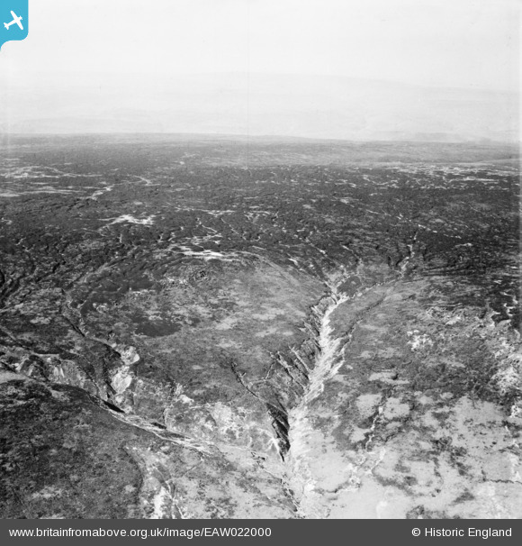
Crowden Brook |
Class31 |
Thursday 6th of March 2014 04:45:25 PM |
Hi Class31, how far up Crowden Brook would you place this? I'm struggling to make the big branch fit and there are no field boundaries of the intakes showing on the older mapping. Yours, Katy Britain from Above Cataloguing Team Leader |
Katy Whitaker |
Tuesday 7th of January 2014 05:11:36 PM |
I put this on the Crowden Brook at the point where the Pennine Way changes from an East -West direction to a North -South direction. Just north west of the word Falls in Blue on the 1:25000 OS. Grid 095873 approx. |
Class31 |
Thursday 9th of January 2014 11:08:48 PM |
Hi Katy I've had another look at this one and I'm wondering where you expect to find any field boundaries as I don't believe there are any, or should be any, in the area covered. Looking at Google earth the present day paths have some resemblence to the heep paths in the photo. There has been an enormous growth in leisure walking in this area over the years. The creation of the Pennine Way meant that a path has been established where none existed at the time of the photo. |
Class31 |
Wednesday 12th of February 2014 07:14:32 PM |
Hi Class31, Alexander and I have been having another look at this image - and regret we still can't quite make it work to our satisfaction. Alexander has recently been up to Crowden Tower (which would be just in/just off the bottom left of the photo if Crowden Brook is correct). Granted the area has changed since the time of the photo - especially in terms of footpaths and visitor erosion because of the opening-up of access. However, there is out-cropping geology in the Aerofilms photo which we can't nail down in the current aerial views (e.g. Google), and we aren't happy with the plan shapes formed by the contours (we are looking at the Next Perspectives Height Contours, 5 metre interval). So we aren't quite ready to give this image a grid reference and administrative authority data without more confidence. Any thoughts? Yours, Katy Britain from Above Cataloguing Team Leader |
Katy Whitaker |
Thursday 6th of March 2014 04:45:25 PM |
The Pennine Way National Trail is a 268 mile walking route from Edale in Derbyshire to Kirk Yetholm in Scotland and was the very first and opened on 24th April 1965. It runs across the area covered by this photograph. |
Class31 |
Sunday 22nd of December 2013 10:56:39 AM |
There is not much to put a name to here. The stream pattern is that of the headwaters of the Crowden Brook. Both Google Earth and Bing look like the area I have indicated. This area has enormous significance for walkers as it is close to the Kinder Scout Mass Trespass which took place on 24th April 1932 to highlight that walkers in England and Wales were denied access to areas of open country. |
Class31 |
Sunday 22nd of December 2013 10:48:57 AM |
Kinder Scout near Crowden Head looking north. Now on the Pennine Way Long Distance Footpath. |
Class31 |
Sunday 22nd of December 2013 10:32:35 AM |