
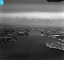
EAW021383 ENGLAND (1949). Helford River, Mawnan, from the east, 1949. This image has been produced from a print.

© Copyright OpenStreetMap contributors and licensed by the OpenStreetMap Foundation. 2026. Cartography is licensed as CC BY-SA.
Details
| Title | [EAW021383] Helford River, Mawnan, from the east, 1949. This image has been produced from a print. |
| Reference | EAW021383 |
| Date | 11-March-1949 |
| Link | |
| Place name | MAWNAN |
| Parish | MAWNAN |
| District | |
| Country | ENGLAND |
| Easting / Northing | 178247, 26498 |
| Longitude / Latitude | -5.1009834113801, 50.096487325161 |
| National Grid Reference | SW782265 |
Pins

redmist |
Tuesday 22nd of November 2022 08:06:01 PM | |
|
redmist |
Tuesday 22nd of November 2022 08:01:09 PM | |
|
CornwallPhil |
Saturday 6th of September 2014 10:00:22 PM | |
|
CornwallPhil |
Saturday 6th of September 2014 09:57:26 PM | |
|
CornwallPhil |
Saturday 6th of September 2014 09:55:29 PM | |
|
CornwallPhil |
Saturday 6th of September 2014 09:54:16 PM | |
|
CornwallPhil |
Saturday 6th of September 2014 09:53:22 PM | |
|
CornwallPhil |
Saturday 6th of September 2014 09:52:18 PM | |
7.5mm is rifle calibre, so would only have been light machine guns!!!! |
Graham Yaxley |
Thursday 18th of December 2014 12:19:44 AM |
User Comment Contributions
Various WW2 features including Toll Point Battery - the first photo I've seen of the Battery |
CornwallPhil |
Saturday 6th of September 2014 10:01:45 PM |